
- CA ON00156 M
- Colección
- 1792-2018
Maps collected by the Hastings County Historical Society and added to by the Community Archives of Belleville and Hastings County. The maps cover locations in Hastings County and extend to all of Canada.
Sin título
897 resultados con objetos digitales Muestra los resultados con objetos digitales
Maps collected by the Hastings County Historical Society and added to by the Community Archives of Belleville and Hastings County. The maps cover locations in Hastings County and extend to all of Canada.
Sin título

The Association of Canadian Clubs Banner
Parte deMap collection
A banner for the Association of Canadian Clubs.
The Women's Canadian Club of Belleville was formed January 31, 1914 to foster Canadian patriotism and presumably dissolved in 1970. It was a member of the Association.

Map of the Canadian National Railway System
Parte deMap collection
A map of the Canadian National Railway System published in 1965. The system composed of; the Central Vermont Railway Inc., the Grand Trunk Western Railroad Co., Duluth, Winnipeg and Pacific Railways Company. Also featuring sponsored hotels, lines under construction and offline traffic offices. The total system mileage is 25,000.
Sin título

A New Map of Upper & Lower Canada
Parte deMap collection
A "New Map of Upper & Lower Canada" published December 1, 1807. Scale: British statute 69.5 miles to a degree. Created by John Cary, engraver and map-seller, No. 181 strand, London.
Sin título

Parte deMap collection
A map of the Dominion of Canada. Map dated 1927. Published by the Department of the Interior (Canada). Scale: 100 miles to 1 inch.
Sin título

Map of Canada indicating Natural Resources
Parte deMap collection
A "Map of Canada - Exclusive of Northern Regions - Indicating Main Natural Resources." Map revised in 1936. Published by the Department of Mines & Resources (Canada). Scale: 100 miles to 1 inch.
Sin título

Map of the Dominion of Canada and Newfoundland
Parte deMap collection
A "Map of the Dominion of Canada and Newfoundland" published by the Copp Clark Co. Ltd. of Toronto in 1945.
The map served dual commercial and educational purposes. It advertises for a chocolate company with slogans and images: "Neilson's, The best chocolate bars in Canada [and] Neilson's Jersey milk chocolate - The best milk chocolate made." On the top right corner, an inscription writes that the map was for rural, underprivileged schools and was not to be removed from such locations.
Sin título
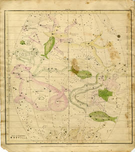
Geography of the Heavens - a Celestial Atlas
Parte deMap collection
A "Celestial Atlas designed to illustrate the Geography of the Heavens" by Elijah Hinsdale Burritt, an American astronomer and mathematician. This second edition was published in 1833 by F. J. Huntingdon in the Clerk's Office of the District Court of Connecticut. The pages are as follows:
Sin título

Philips' School-room Map of Europe
Parte deMap collection
"Philips' School-room Map of Europe" as composed by George Philip & Son Ltd. and published by London Geographic Institute. The map was drawn after the Treaty of Versailles and before the formation of the Soviet Union (USSR).
Sin título

Reproduction of a map of Upper Canada
Parte deMap collection
Reproduction of a map showing "the Routes Lt. Gov. J. G. Simcoe took on trips" throughout Upper Canada from March 1792 to September 1795. The map was charted by Lt. Gov. Simcoe. A good depiction of the area now referred to as Southern Ontario and his plans for a capital there - "London." This map was published as part of "Charting Our Past" from the Archives of Ontario by Stonehouse Publications.
Scale: about 20 miles to an inch.

Proposed Towns and Military Roads of Upper Canada
Parte deMap collection
Poor reproduction of a sketch of Upper Canada to show places designated by Lt. Gov. Simcoe for towns and proposed military roads, circa 1796. The map was published by B. M. Kings.

Reproduction of a map of the province of Upper Canada
Parte deMap collection
Reproduction of a map showing new settlements, townships, counties etc.in the province of Upper Canada as of April 12, 1800. The total area spans from Quebec to Lake Huron and from Lake Michigan to New Hampshire then south to Pennsylvania in the U.S.A. This was the first printed map of Upper Canada, showing all settlements since 1784. Charted by D. W. Smith, Esq., Surveyor General London and published by W. Faden.
This map was published by Stonehouse Productions as part of "Charting Our Past" from the Archives of Ontario.
Sin título

Map of the principal settlements of Upper Canada (Part 1)
Parte deMap collection
Reproduction of Part 1 of a map showing a plan of the Principal Settlements of Upper Canada in 1817. The area covers from Eastern to Midland to Home District.
This map can be found the Archives of Canada.

Map of the principal settlements of Upper Canada (Part 2)
Parte deMap collection
Reproduction of Part 2 of a map showing a plan of the Principal Settlements of Upper Canada in 1817. The area covers from Northumberland to Essex counties.
This map can be found the Archives of Canada.
Map of Lower Canada, Quebec and Ontario
Parte deMap collection
A reproduction of part of a map showing Lower Canada, Quebec and Ontario in 1825. Map shows bodies of water and names of settlements. The boundary of Lower Canada is according to a treaty with the United States. From the Archives of Canada on July 27, 1966. Donated by Chewett.

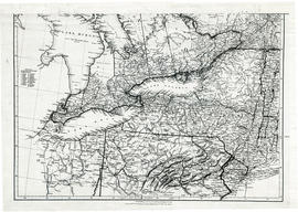
Map of Upper Canada and United States
Parte deMap collection
A map showing settlements of Upper Canada and part of the United States in 1834 by J. Arrowsmith.
Received from the Archives of Canada's map collection - July 9, 1971.
Sin título
Parts of Ontario and USA in 1834
Parte deMap collection
A map showing settlements of Ontario and part of the United States in February 1834 by J. Arrowsmith. The total area extends from Lake Huron East to Montreal and south Ohio to Long Island.
Received from the Archives of Canada's map collection - 11 May 1977.
Sin título
Parte deMap collection
Map showing Upper Canada settlements in 1835. From the Archives of Canada.
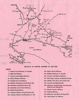
Map of Central Ontario Railways in 1847-1889
Parte deMap collection
A map detailing the railways during 1847-1889 in Central Ontario. The legend assigns a number to the name of each railway. Composed and published by William Michaud of Shannonville, Ontario.
Sin título

Maps of the Districts of Upper Canada
Parte deMap collection
4 maps showing the Districts of Upper Canada between 1788-1849: