
- CA ON00156 2019-063
- Collection
- 1932-2000
Four photograph albums of newspaper clippings and photographs relating to the activities of St. Andrew's Presbyterian Church in West Huntingdon.
St. Andrew's Presbyterian Church (West Huntingdon)
19 results with digital objects Show results with digital objects
Four photograph albums of newspaper clippings and photographs relating to the activities of St. Andrew's Presbyterian Church in West Huntingdon.
St. Andrew's Presbyterian Church (West Huntingdon)

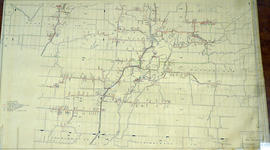
Hastings with Town of Belleville and principal villages
Part of Map collection
A map of Hastings County including the Town of Belleville and other principal villages:
Trenton, Madoc, Marmora, Tweed, Bridgewater, Stirling, Wicklow, Bangor, Herschel, Monteagle, Carl, Dungannon, Wollaston, Limerick, Cashel, Tudor, Grimsthorpe, Elzevir; Rawdon, Huntingdon, Hungerford, Sidney, Thurlow, Tyendinaga.
Scale: 3 miles =1 inch. Published by John P. Evans, P.L.S. in 1869.
Evans, John Dunlop, P.L.S.

Huntingdon Township Map # 444772W
Part of Map collection
A reproduction of an air survey photograph produced by the Ontario Ministry of Natural Resources. Map # 444772W of Huntingdon Township in Hastings County, Ontario. Circa 1950.
The photograph shows Huntingdon Township, Fuller Village north to Concession 13 and Moira Lake.
Donated by Walter I. Watson, P.L.S.
Ontario. Ministry of Natural Resources and Forestry

Hydro-Electric Power Commission of Ontario, Frankford Section
Part of Map collection
An original map produced for the Hydro-Electric Power Commission of Ontario, concerning hydro power lines, stations and transformers. However, the map also features railways, roads and land boundaries.
This map is of the North Section - Frankford Rural Power District. The total area includes parts of Thurlow, Huntingdon, Sidney, Rawdon, Campbellford, Seymour, Brighton, and Percy Townships. Circa 1950.
Donated by David Pershik.
Hydro-Electric Power Commission of Ontario, Tweed Section
Part of Map collection
An original map produced for the Hydro-Electric Power Commission of Ontario, concerning hydro power lines, stations and transformers. However, the map also features railways, roads and land boundaries.
This map is of the Southwest Section - Tweed Rural Power District. The total area includes parts of Hungerford, Huntingdon, and Thurlow Townships. Dated October 16, 1951. Scale: 2 inches = 1 mile.
Donated by David Pershik.
Hydro-Electric Power Commission of Ontario, Tweed-Section
Part of Map collection
An original map produced for the Hydro-Electric Power Commission of Ontario, concerning hydro power lines, stations and transformers. However, the map also features railways, roads and land boundaries.
This map is the West Centre Section - Tweed ROA. The total area includes parts of Rawdon, Marmora, Huntingdon, Madoc, Hungerford, and Elzevir Townships. Dated October 16, 1951. Scale: 1.2 inches = 1 m.
Donated by David Pershik.

Lloyd's Map of Hastings County
Part of Map collection
A map of Hastings County outlining the twelve townships:
Marmora and Lake, Madoc, Tudor, Grimsthorpe, Elzevir; Rawdon, Huntingdon, Hungerford, Sidney, Thurlow, Tyendinaga. The northern townships are pictured on the right side.
As well as, the lots and concessions. Circa 1922. Scale: 1.5 miles: 1 inch. Published by Lloyd's Maps, Map Publisher.
Lloyd's Map, Map Publisher

Map of Hastings and Prince Edward Counties
Part of Map collection
A map showing the roads, forts and inns of Hastings and Prince Edward Counties in 1850, by Major Baron DeRottenburg. The map extends from Brighton to Gananoque, Prince Edward County. and North to include Rawdon, Huntingdon, Hungerford Townships of Hastings County. Scale: 2 miles = 1". Dimensions 63cm x 44cm.
DeRottenburg, Major Baron

Map of Hastings County in 4 sections
Part of Map collection
A map of Hastings County outlining townships from the Bay of Quinte in the south, to Wallaston, Limerick and Cashel in the north.
Map is in four sections. Scale: 3 miles : 1 inch. Original map is dated 1894. Photocopy from the Archives of Ontario.

Map of Hastings with the Principal Villages and the City of Belleville
Part of Map collection
A map of Hastings County including the Town of Belleville and other principal villages:
Trenton, Madoc, Marmora, Tweed, Bridgewater, Stirling, Wicklow, Bangor, Herschel, Monteagle, Carl, Dungannon, Wollaston, Limerick, Cashel, Tudor, Grimsthorpe, Elzevir; Rawdon, Huntingdon, Hungerford, Sidney, Thurlow, Tyendinaga.
Scale: 3 miles =1 inch. Published by Evans & Bolger, P. L. Surveyors, P.L.S. in 1879-1880.
Evans and Bolger

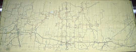
Map of Hastings with townships
Part of Map collection
A map of Hastings County outlining the twelve townships:
Marmora and Lake, Madoc, Tudor, Grimsthorpe, Elzevir; Rawdon, Huntingdon, Hungerford, Sidney, Thurlow, Tyendinaga.
As well as, the lots and concessions. Circa 1916.Scale: 4 miles: 1 inch.
Donated by K.G.M. Ross.

Map of Southern Hastings County
Part of Map collection
Southern Hastings County in 1963. Map features boundaries, roads and railways. Scale: 1:63,360. Published by the Department of Highways, Ontario. Made by Hunting Survey Corp. Ltd. Dimensions 107.5cm x 92.5cm.
A unique "one-inch" map because all one-inch series maps were converted to 1:50,000 after 1950. However, this map was converted to 1:63,360.
Ontario. Department of Highways

Map of the Counties of Hastings and Prince Edward
Part of Map collection
A "Map of the Counties of Hastings and Prince Edward." In 1898, the lots, concessions, churches, schools and mines are shown of the townships in Hastings and Prince Edward. Scale: 1.5 miles to an inch. Published by the Canadian Map Publishing Company in Hamilton, Ontario, for the Belleville Sun. Revised by Henry Carre, C.E. Inset is the map of North Hastings, scale 400 chains to an inch.
Carre, Henry, O.L.S.

Plan of Hastings for Hastings Directory
Part of Map collection
A map of Hastings County outlining townships:
Marmora, Lake, Madoc, Tudor, Grimsthorpe, Elzevir; Rawdon, Huntingdon, Hungerford, Sidney, Thurlow, Tyendinaga - as well as the northern townships.
Inset is "the Village of Marmora." Surveyed by H. A. F. Macleod, C.E. and P.L.S. Published by W. A. Little Lith., Montreal in the 1864-1865 copy of the Hastings Directory . Scale: 1:190,000.
MacLeod, Henry Augustine Fitzgerald, P.L.S.

Plan of Rollins Block in the Township of Madock
Part of Map collection
A certified reproduction of the "Rollins Block - Lots on part of Lot # 1 in Concession 5, Township of 'Madock' for proprietor Samuel Rollins.” Rollins Block is between Lot # 2 in 5th Concession of 'Madock', the road between Huntingdon & 'Madock' Township, Francis Street and lastly the road between 5th and 6th Concession of 'Madock.' Surveyed by John Emerson, P.L.S ., and signed October 3, 1875.
This copy was made in 1972 of plan #193, as registered in the Hastings Land Registry Office.
Donated by Walter I. Watson, P. L. S.
Emerson, John, P.L.S.
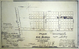
Plan of South Hastings in the Township of Huntingdon
Part of Map collection
A certified reproduction of the Plan of South Hastings laid out on Lot # 12, 14th Concession of Huntingdon, for Charles. Kirk. Surveyed by C. F. Ayslworth Sr., P.L.S. and signed March 27, 1867.
This copy was made in 1972 of plan #118, as registered in the Hastings Land Registry Office.
Donated by Walter I. Watson, O.L.S.
Aylsworth, Charles Fraser Sr., P.L.S.

South and Central Hastings Map
Part of Map collection
"Cummins Rural Directory Map:" A map of South and Central Hastings, in 1923, featuring post offices, hamlets and lot owners. Map is surrounded by advertisements. Published by Cummins Map Co., Toronto. Dimensions 71cm x 50.5cm.
Cummins Map Company

Subdivision of Lots 11-12 in the Township of Huntingdon
Part of Map collection
A certified reproduction of the "Subdivision of part Lots # 11 & 12, Concession 13, Township of Huntingdon.” The area includes; Moira Lake, old County Road Hwy 62 and proposed new bridge. Surveyed by John Thomas Ransom, O. L. S. and signed November 10, 1960.
Donated by Walter I. Watson, P. L. S.
Ransom, John Thomas, P.L.S.

Subdivision of Lots 12-13 in the Township of Huntingdon
Part of Map collection
A certified reproduction of the "Subdivision of part Lots # 12 & 13, Concession XIII, Township of Huntingdon.” The area includes; north shore of Moira Lake, and east of County Road No. 1. Surveyed by John Thomas Ransom, O. L. S. and signed March 13, 1957.
Donated by Walter I. Watson, P. L. S.
Ransom, John Thomas, P.L.S.