
Sprague Family, Prince Edward County History
- CA ON00156 TR/2771
- Item
- c. 1900
This file contains a newspaper clipping titled "The Sprague Family: How They Migrated From New York to Prince Edward".
Sprague Family, Prince Edward County History
This file contains a newspaper clipping titled "The Sprague Family: How They Migrated From New York to Prince Edward".

Mullett, John & Family : pioneers of Prince Edward County
File contains a newspaper article from The Picton Gazette concerning the life of the family of John Mullett, an early settler of Prince Edward County who established the Morocco Leather Company in Picton ca. 1833 on the site of the present Glenwood Cemetery.

Prince Edward Militia : court martial, 1839
File contains a newspaper clipping regarding a document about a June 1839 court martial trial held in Consecon, Ontario, of thirty-five members of the Prince Edward Militia charged with various offences.

File contains one page ts. history of the Boulter Canning Factory, the first canning factory in Central Ontario, est. 1882.

Marysburgh; settlement 1784-1850
File containing booklet on the history of the founding of Marysburgh and township council records from 1850-1.

Hydrographic Map of Bay of Quinte, Picton to Presqu'ile Bay
Part of Map collection
A hydrographic map of the area surrounding the Bay of Quinte, Picton to Presqu'ile Bay in Ontario, Canada. With maps of Trenton Approaches, [racist slur redacted] Narrows, Belleville Harbour & Telegraph Narrows inset. Surveys completed in in 1952-53 and 1957. Map printed June 15, 1962. Published by the Canadian Hydrographic Service, Marine Sciences Branch, Department of Mines and Technical Surveys, Ottawa. Sheet number 2069.
Canadian Hydrographic Service

A family history on the Wilkins' family. 2 pages.

Topographical map of Duck Island
Part of Map collection
A topographical map of Duck Island- Canada sheet #30 N/15. Published by the Army Survey Establishment, Department of National Defence in 1932. Scale one inch to one mile - 1/63, 360.
Donated by Gerry Boyce.
Canada. Department of National Defence

Topographic Map of Ontario - Belleville Sheet
Part of Map collection
A map from the Eastern Canada series entitled "Topographic Map of Ontario - Belleville Sheet 31 C/3." The map includes Hastings County to Hillier in Prince Edward County. Published in 1938 by the Department of National Defence. Scale 1 inch to 1 mile.
Donated by the Belleville Public Library in 2014.
Canada. Department of National Defence

McFarland, Harvey, Picton mayor attendance at the Nixon inauguration, January 1969
File contains a newspaper article concerning Picton Mayor H. J. McFarland's departure on January 20, 1969 to attend the U.S. presidential inauguration of Richard M. Nixon.
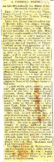
Young, Lieut. Col. Reuben Young - Obituary 1899
File contains the obituary (7-February-1899) for Lt. Col. Reuben Young. Born 19-July-1805 in Carrying Place, oldest son of Lieut. Col. James Young, M.P. Lt. Col. Reuben Young married Nancy Briant in 1829, she predeceased him 10 years.

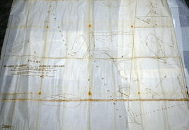
Weller's and Hay Bay Islands claimed by Alnwick Indians
Part of Map collection
An original, waxed linen map entitled "Plans of Islands claimed by the band of Alnwick Indians. Pursuant to Instructions bearing date “Crown Lands Department” Quebec 2nd October 1861." The area in mention concerns Weller's Bay and Hay Bay, in Prince Edward County. Surveyed by John McNaughton, P. L. S. in April and May 1862. Scale: 8 chains to an inch.
McNaughton, John, P.L.S. & D.P.S.

West Lake Islands claimed by Alnwick Indians
Part of Map collection
An original, waxed linen map entitled "Islands claimed by Alnwick Indians, Pursuant to Instructions bearing date Crown Lands, Dept. Quebec 2nd October 1861." The area in mention concerns the West Lake Islands, in Prince Edward County. Surveyed by Duncan McDonell Greenfield and John McNaughton, P. L. S. in May and June 1862. Scale: 8 chains to an inch.
McNaughton, John, P.L.S. & D.P.S.
Huyck Islands claimed by Alnwick Indians
Part of Map collection
An original, waxed linen map entitled "Islands claimed by Alnwick Indians, Pursuant to Instructions bearing date Crown Lands, Dept. Quebec 2nd October 1861." The area in mention concerns the Huyck Bay Islands, Lake Ontario, and Pleasant Bay. Surveyed by Duncan McDonell Greenfield and John McNaughton, P. L. S. in May, June, July and August, 1862. Scale: 8 chains to an inch.
McNaughton, John, P.L.S. & D.P.S.

Map of the Counties of Hastings and Prince Edward
Part of Map collection
A "Map of the Counties of Hastings and Prince Edward." In 1898, the lots, concessions, churches, schools and mines are shown of the townships in Hastings and Prince Edward. Scale: 1.5 miles to an inch. Published by the Canadian Map Publishing Company in Hamilton, Ontario, for the Belleville Sun. Revised by Henry Carre, C.E. Inset is the map of North Hastings, scale 400 chains to an inch.
Carre, Henry, O.L.S.

Plans for COR Station at Picton
Part of Map collection
A blueprint of the proposed new COR station at Picton, Prince Edward County, Ontario. Drawn by John Dunlop Evans, Chief Engineer. Published by the Office of Master of Bridges and Buildings G.T.R. in December 1901.
Evans, John Dunlop, P.L.S.

Plans for COR Station at Picton
Part of Map collection
A blueprint of the proposed new COR station at Picton, Prince Edward County, Ontario. Drawn by John Dunlop Evans, Chief Engineer. Published by the Office of Master of Bridges and Buildings G.T.R. in December 1901.
Evans, John Dunlop, P.L.S.

Plans for COR Station at Wellington
Part of Map collection
A blueprint of the proposed new COR station at Wellington, Prince Edward County, Ontario. Drawn by John Dunlop Evans, Chief Engineer. Published by the Office of Master of Bridges and Buildings G.T.R. on March 23, 1911.
Evans, John Dunlop, P.L.S.

COR Station at Bloomfield Plans
Part of Map collection
A blueprint planning the COR passenger station at Bloomfield, Hastings County, Ontario. Plan features floor, platform plans, elevation and sections. Drawn by John Dunlop Evans, Chief Surveyor/Engineer - July 24, 1909.
Evans, John Dunlop, P.L.S.

Topographical Map of Ontario - Belleville Sheet
Part of Map collection
A map of Hastings, Prince Edward, Northumberland and Peterborough counties in 1929 from the Department of Interior Canada. By J.E. Chalifour, Chief Geographer. Scale: 1" to 3.95 miles.
The legend includes additional information about counties, towns, villages, boundaries, railways, canals, lots, concessions, portages, rapids and First Nations Territories.
Canada. Department of the Interior