- CA ON00156 2010-41
- Item
- c.1980
Map showing the location and dates of shipwrecks around the shoreline of Prince Edward County.
Ralley, Allan A.
33 results with digital objects Show results with digital objects
Map showing the location and dates of shipwrecks around the shoreline of Prince Edward County.
Ralley, Allan A.
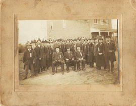
Ancient Order of United Workmen, Lodge 262 photograph
Photograph of members of the Ancient Order of United Workmen, Lodge 262 (Ameliasburgh) and two newspaper clippings from 1983 relating to the society.
Individuals identified are:
Seated: 1. ? Carnrite [Carnrike?]
James E. Glenn
Albert Lont
Dorland Fox
Dr. File M.D.
Moran Lont
Lewis Lont
Fred File
Gil Choat?
Byron Frederick
Ferris Wood
Francis Wood
John Tice
James A. Van Cott
William Bisdee
Charles Wood
Jessie Sprong
Albert Crosby
Will Reddick
Edgar Redner?
Fred Lauder?
Part of Lewis Zandbergen collection
An unused postcard with a photo reprint of Main Street, Picton, Ontario.
Prismaflex Color
'Tracing a United Empire Loyalist Family Story Rooted in the Quinte Area: Unfolding one branch of the Redner Tree'. Illustrated family history of the descendants of Johannes Ridenour (Redner), inhabitants of Prince Edward County and Belleville, Ontario.
Theobald, Clark Ian

Quinte's Isle of Lakes and Bays promotional booklet
Promotional booklet advertising businesses in Prince Edward County, Ontario.
Picton Gazette Publishing Company

Part of County of Hastings records
Digital copy of 1893 Union Publishing Company's directory of the Counties of Durham, Hastings, Lennox, Addington, Northumberland, Prince Edward

Part of County of Hastings records
Digital copy of 1899 Union Publishing Company's directory of the Counties of Frontenac, Hastings, Lennox, Addington, Prince Edward

Part of County of Hastings records
Digital copy of 1884 Union Publishing Company's directory of the Counties of Frontenac, Hastings, Lennox, Addington, Prince Edward
Part of County of Hastings records
Digital copy of 1886 Directory of the Counties of Frontenac, Hastings, Lennox, Addington, Prince Edward

Map of Hastings and Prince Edward Counties
Part of Map collection
A map showing the roads, forts and inns of Hastings and Prince Edward Counties in 1850, by Major Baron DeRottenburg. The map extends from Brighton to Gananoque, Prince Edward County. and North to include Rawdon, Huntingdon, Hungerford Townships of Hastings County. Scale: 2 miles = 1". Dimensions 63cm x 44cm.
DeRottenburg, Major Baron

Map Hastings, Prince Edward, Northumberland and Peterborough Counties
Part of Map collection
A map of Hastings, Prince Edward, Northumberland and Peterborough counties in 1916 from the Department of Interior Canada. Published by J.E. Chalifour, Chief Geographer. Scale: 3" to 95 miles. Dimensions 63.5cm x 96.5cm.
The legend includes additional information about counties, towns, villages, boundaries, railways, canals, lots, concessions, portages, rapids and First Nations Territories.
Canada. Department of the Interior
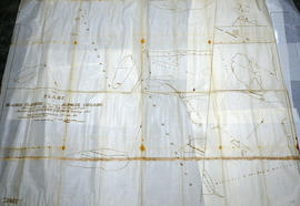
Huyck Islands claimed by Alnwick Indians
Part of Map collection
An original, waxed linen map entitled "Islands claimed by Alnwick Indians, Pursuant to Instructions bearing date Crown Lands, Dept. Quebec 2nd October 1861." The area in mention concerns the Huyck Bay Islands, Lake Ontario, and Pleasant Bay. Surveyed by Duncan McDonell Greenfield and John McNaughton, P. L. S. in May, June, July and August, 1862. Scale: 8 chains to an inch.
McNaughton, John, P.L.S. & D.P.S.
Map of Rivers and Lakes of Prince Edward County
Part of Map collection
Map showing depths of water and fishing areas[?] of the Bay of Quinte, from Belleville to Big Island and North Port.
van Burren, Jack
Forestry in the Townships of Hastings and Prince Edward Counties
Part of Map collection
Forestry maps of Ameliasburgh, Murray, Rawdon, Sidney and Thurlow townships from 1980.
Map of Townships by waterfront and Mohawk Territory
Part of Map collection
Map showing townships by the waterfront of the Bay of Quinte and the Mohawk Territory. This area encompasses townships in both Prince Edward and Hastings Counties. Text on map says "District of Nassau." Dated 1790. Map copied from the Archives of Ontario.

Map of District of Prince Edward County
Part of Map collection
Map showing townships in the District of Prince Edward County: South Murray, Sidney, Thurlow, Ameliasburgh, Sophiasburgh. See boundary lines on map. Surveyed by Publius Virgillius Elmore, D.L.S. Dated 1835. Map copied from the Archives of Ontario.
Elmore, Publius Virgillius, D.P.S.

Map of Districts of Prince Edward and Midland
Part of Map collection
Map showing counties, townships, concessions and lots in the Districts of Prince Edward and Midland. Surveyed by Publius Virgillius Elmore, D.L.S. Published by Hallowell U.C. Dated 1836. Scale 160 chains : 1". Map copied from the Archives of Ontario.
Elmore, Publius Virgillius, D.P.S.

Map of the Counties of Hastings and Prince Edward
Part of Map collection
A "Map of the Counties of Hastings and Prince Edward." In 1898, the lots, concessions, churches, schools and mines are shown of the townships in Hastings and Prince Edward. Scale: 1.5 miles to an inch. Published by the Canadian Map Publishing Company in Hamilton, Ontario, for the Belleville Sun. Revised by Henry Carre, C.E. Inset is the map of North Hastings, scale 400 chains to an inch.
Carre, Henry, O.L.S.

Part of Map collection
A map of Prince Edward County featuring information about local historical traditions, agriculture, community life and geography. Published in 1937 through Picton Times by Conger Allison. Dimensions: 72cm x 53cm.
Allison, Conger

Road Map of Hastings and Prince Edward Counties
Part of Map collection
A map of Hastings and Prince Edward Counties from 1958. Titled "All roads lead to the City of Belleville and the Highlands of Hastings." Dimensions 19cm x 36cm.