- CA ON00156 TR/2954
- File
- 1615
File contains documents and a newspaper clipping about the early years of Trenton's history. It begins c.1615, and ends around c.1919.
869 results with digital objects Show results with digital objects
File contains documents and a newspaper clipping about the early years of Trenton's history. It begins c.1615, and ends around c.1919.
Reproduction Map of Carte de la nouvelle France
Part of Map collection
A reproduction of Carte de la nouvelle France by Samuel de Champlain in 1652. Includes regions to Virginia, from Newfoundland to Lake Superior.
Archives of Ontario
Reproduction Map of Le Canada and Nouvelle France
Part of Map collection
A reproduction of Le Canada, ou Nouvelle France map by Nicolas Sanson. Original map made in 1656. Includes area extending from west Lake Superior to Newfoundland.
Canada. Department of Energy, Mines and Resources
Reproduction Map of Amerique Septentrionale
Part of Map collection
A reproduction of "Amerique Septentrionale divisee en ses principales parties ou sont distingue's les vns des autres Les Estats" map by Nicolas Sanson. Original map made in 1695. Includes area in modern day Canada and USA.
Canada. Department of Energy, Mines and Resources
Part of Map collection
A 1719 map of Canada (New France) covering the explored areas of Canada previously featured on Guillaume de l'Isle's former map of 1703. Reproduction published by Stonehouse Publications in St. Catharines, Ontario.
Received from the Archives of Ontario.

An Accurate Map of Canada with the adjacent Countries
Part of Map collection
A reproduction by the Canadian Department of Energy, Mines and Resources of "An Accurate Map of Canada with the adjacent Countries Exhibiting the late Seat of War between the English & French in those parts." Original map was issued in 1761 at London. Includes the areas named; New South Wales, New Britain, Canada, south Louisiana, Virginia, "Pennsilvania," New York and New England. The names and location of Indigenous peoples are also featured on the map.
Donated by Gerry Boyce.
Canada. Department of Energy, Mines and Resources

Reproduction of Carte des Cinq Grands Lacs du Canada
Part of Map collection
Map showing "The 5 Big Lakes of Canada" by Jacques Nicholas Bellin, Paris, 1764. Bellin produced a maritime atlas containing this map, showing the topography, forts, portages and the Mission Ste. Marie in the Great Lakes area. This map was published by Stonehouse Productions as part of "Charting Our Past" from the Archives of Ontario.
Bellin, Jacques Nicolas
Traced Map of Canada and the North Part of Louisiana
Part of Map collection
A reproduction of "A Map of Canada and the North Part of Louisiana with Adjacent Countrys by Thomas Jefferys, Geographer to His Royal Highnefs the Prince of Wales." Original map was hand colored and published in 1768.
Jefferys, Thomas

A New and Accurate Map of Part of North America
Part of Map collection
A reproduction of "A New and Accurate Map of Part of North-America, Comprehending the Provinces of New England, New York, Pennsilvania, New Jersey, Connecticut, Rhode Island & Part of Virginia, Canada and Halifax, For the Illustration of M. Peter Kalms Travels." Written at the bottom is "Publish'd according to Act of Parliament Mrahc 7th, 1771."
Ketcheson, William Family History
File contains the family history and biography of William Ketchison (b. 1760, d. 1848).
Reproduction of an Accurate Map of North America
Part of Map collection
A reproduction of an "Accurate Map of North America Deferring and distinguishing the British and Spanish Dominions on this great Continent." Original map made in 1775 and held at the Archives of Ontario.
Archives of Ontario

The Wanamaker fonds consists of textual records and graphic materials of genealogical histories of various families. The fonds also contains records, brochures, pamphlets, publications, books, and other textual records from towns and cities throughout Ontario, predominantly from the Quinte Area and Hastings County.
Genealogical family research names:
Wanamaker, Castello Loral Roy

Copy of a Map of the Province of New York and Jersey
Part of Map collection
A reproduction of "A New & Accurate Map of the Province of New York and Part of the Jerseys, New England and Canada. Showing the Scenes of our Military Operations during the Prejant War- Also the New Erected State of Vermont." Originally published by J. Bow on October 31, 1780. Date of reproduction is unknown.
Donated by the Belleville Public Library in 2014.
Thurlow Township : historical notes from 'The Rambling River'
File contains a typescript excerpt of The Rambling River, written and compiled by Mary G. Plumption, concerning the early settlement of Thurlow Township from 1784, together with brief biographical information on Lord Thurlow, and Baron Rawdon, Earl of Moira. Also present are four printed lists of Thurlow Township land holders by name and date of patent from 1798-1818.

Map of Fredericksburg Township
Part of Map collection
A survey plan map of the Township of Fredericksburg, 1784. Contains names of local property owners and bodies of water. Composed by James Peachy, Lewis Kotte, Henry Holland and Samuel Jaffe. Scale: 40 chains in an inch. Dimensions: 53cm x 39cm.
Peachey, James, D.L.S.
Teacher's Guide to Quinte in 1785
Part of Map collection
Map showing the Bay of Quinte to Presqu'ile to the eastern tip of Grande Isle (Wolfe Island) used as a teacher's guide to the area in 1785. The 20th century names are in capital letters as per the Legend.
Part of Map collection
A copy of an original map by Surveyor General John Collins showing land from Presqu'ile to Kingston in 1785. Scale: 4 miles : 1 inch.
Photocopied by the Archives of Canada 10 Jan 1990.
Collins, John, Hon.
Map of Thurlow Township 1787 (reproduction)
Part of Map collection
Map showing Thurlow Township in 1787. Photocopy received from the Archives of Canada July 16, 1978.
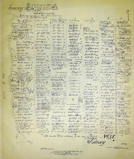
Map of Sidney Township in 1787 - 1981 rewrite
Part of Map collection
A recopy of the 1787 map of Sidney Township. The original map entitled "Plan of the Township of Sidney in the District of Mecklinburg. Surveyed in 1787 by Lewis Kotts, with the names of the proprietor inserted in the Lots." The recopy was completed by Mrs. Dorothy Ashton in 1981, for the Corby Public Library and Hastings County Historical Society. Scale 40 chains to an inch.
Donated by the Belleville Public Library in 2014.
Kotte, Lewis
Thurlow : Grantees of Thurlow (Original)
File contains a photocopy from the original of land grants including name of grantee, date, acreage,concession and lot in Thurlow Township from 1787-ca.1890.