
- CA ON00156 HCHS/6/2/39
- File
- 2014
Display panels on the women who were appointed to be the Hastings County Plowing Match 'Queen of the Furrow'.
Display panels on the women who were appointed to be the Hastings County Plowing Match 'Queen of the Furrow'.

Postcards of Trenton High School and H. C. Pitcher & Son, Frankford
Two postcards:
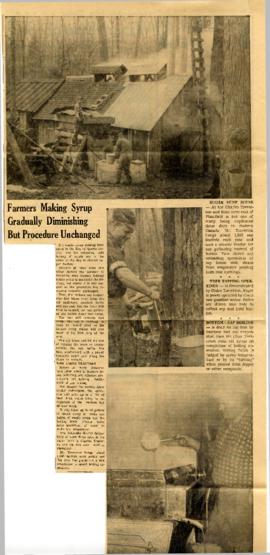
Thurlow Township : maple syrup making 1966
File contains two copies of a newspaper article from the Stirling News Argus concerning maple-syrup making at the Charles Treverton and Sons Farm, near Plainfield in 1966.
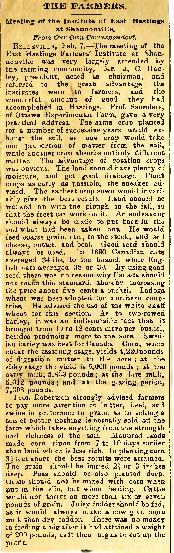
Farmers' Institute East Hastings
File contains a newspaper clipping concerning a meeting of East Hastings' Farmers' Institute at Belleville, where crop yields and mixed farming were discussed.

Resources Map of Hastings County
Part of Map collection
Resources map of Hastings County, Ontario, showing agricultural activity and natural resources.

Photograph of Mike Stanko and Clare Homan
Photograph taken at John and Leatha Homan's farm on Harmony Road in Corbyville, Hastings County, Ontario. It shows Mike Stanko, a displaced person from Poland who came to Canada after the Second World War, and the Homan's son, Clare, next to a car.

Ploughing Match, Hastings County : special edition, 1961
File contains a special edition of The Ontario Intelligencer, 3 October 1961, devoted to the opening ceremonies and daily programs of events of the International Plowing Match, which was hosted by Belleville and Hastings County.

Part of Map collection
A map of Prince Edward County featuring information about local historical traditions, agriculture, community life and geography. Published in 1937 through Picton Times by Conger Allison. Dimensions: 72cm x 53cm.
Allison, Conger

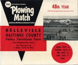
1961 Internatinal Plowing Match Prize List
Printed prize list of the 1961 International Plowing Match and Farm Machinery Demonstration in Belleville, Ontario.

Farmstead Improvement Contest Brochure
Printed brochure of rules, classes, judges, awards, and suggestions for the Hastings County Farmstead Improvement Contest, part of the 1961 International Plowing Match and Farm Machinery Demonstration in Belleville, Ontario.

1961 International Plowing Match Badge
A silk ribbon and badge from the 1961 International Plowing Match, belonging to Official T.G. Wrightmeyer.

1961 International Plowing Match Ribbon
A silk ribbon bearing the inscription “International Plowing Match, City of Belleville, Hastings County" on one side, and the dates of the match on the other.

1961 International Plowing Match Banquet Programme
A programme for the 1961 International Plowing Match banquet held at the Belleville Armouries, 6 October 1961.

1961 International Plowing Match Official Program
Official program of the 1961 International Plowing Match in Belleville, Ontario, printed by Family Herald magazine.

Biographical notes on Harry Danford of Rawdon Township
Notes on the Danfords of Stirling-Rawdon and nomination for an award for Harry Danford by the Hastings County Plowing Match and Farm Show, 2008.
Danford, Harry
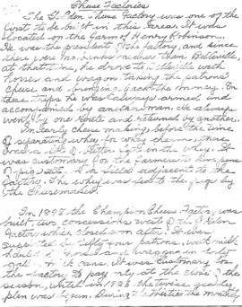
Madoc Township : history of cheese factories
File contains a photocopied brief manuscript history of cheese factories in Madoc Township.

Display of newspaper articles on 1986 International Plowing Match
Part of Records of the Community Archives of Belleville and Hastings County
Collection of scanned newspaper articles on the 1986 International Plowing Match held at Stirling, Ontario.

Display of photographs of 1986 International Plowing Match
Part of Records of the Community Archives of Belleville and Hastings County
Collection of scanned Intelligencer negatives taken at the 1986 International Plowing Match held at Stirling, Ontario.

Part of Map collection
A Soil Map of Hastings County Ontario, South Sheet, Soil Survey Report # 27. Published by the Experimental Farms Service of Ottawa. in 1958. Base maps supplied by the Department of Mines and Technical Surveys. Soil survey by the Department of Soils, Ontario Agricultural College, Guelph and the Experimental Farms Service, Canada Department of Agriculture, Ottawa. Scale 1 inch to 1 mile.
Canada. Department of Agriculture
1961 Internatinal Plowing Match Programme
Printed official programme and prize list of the 1961 International Plowing Match and Farm Machinery Demonstration in Belleville, Ontario.