Showing 1540 results

Archival description
Ontario With digital objects
Print preview Hierarchy View:

Reproduction of Carte des Cinq Grands Lacs du Canada

Map showing "The 5 Big Lakes of Canada" by Jacques Nicholas Bellin, Paris, 1764. Bellin produced a maritime atlas containing this map, showing the topography, forts, portages and the Mission Ste. Marie in the Great Lakes area. This map was published by Stonehouse Productions as part of "Charting Our Past" from the Archives of Ontario.

Bellin, Jacques Nicolas

Wanamaker records

  • CA ON00156 MG 27
  • Fonds
  • 1778-1984

The Wanamaker fonds consists of textual records and graphic materials of genealogical histories of various families. The fonds also contains records, brochures, pamphlets, publications, books, and other textual records from towns and cities throughout Ontario, predominantly from the Quinte Area and Hastings County.

  • Family Photographs of the Sayers family, Ralph Wanamaker's family, the Hodgen family, of Loral Wanamaker's family, Parliament family, Van Cott family, Post family, as well as loose photographs of the Parliament family, the McTaggart family, various snapshots and negatives of scenery and views, as well as 2 boxes of slides
  • 1 box of Books and Binders with genealogical records, as well various records of various towns in Ontario ca. 1816 - 1957
  • Genealogical notes, histories, birth records, death records, pages from family Bibles, receipts, and other textual records for over 40 individual families
  • Genealogical charts, and ancestral charts
  • Genealogical correspondences
    *Newspapers, and News clippings from Hastings County, Hastings County Museum, Historical Society, Lennox and Addington, Prince Edward County, Trenton, Tyendinaga, and United Empire Loyalists
  • Legal documents, seals and original deeds, and land records ca. 1803 - 1848
  • Genealogy forms, research materials, reference materials
  • Various artworks and postcards (of Hastings County, the Quinte Region, the British Military and Navy, the Belleville Art Association, and travel)
  • Quinte region, Belleville, Trenton, and Prince Edward County miscellaneous publications, newspaper clippings, brochures, pamphlets, notes, directories, histories, records, and tourism guides and publications
  • Ontario, New York , and Canada pamphlets, magazines, calendars, and an Ontario Liquor License Act, 1891
  • Land Abstracts for Prince Edward County
  • Maps and plans: 1778-1779 Blue Print Surveys from General Washington, New York Historical Society; 1784 Ontario (printed by Ministry of Natural Resources), 1984; 1860-1861 Hastings County, 1860-1861 from the Hastings County Directory; 1928 Lloyd's Map of Hastings County; c. 1930 Belleville Post Office Carrier Route #8, North Front and North Park Streets
  • Scrapbooks ca. 1958-1972
  • Miscellaneous Publications (almanacs, newspaper clippings, miscellaneous pins belonging to Loral Wanamaker, blue print surveys)

Genealogical family research names:

  • Allison
  • Alyea
  • Babcock, John
  • Bailey
  • Belnap
  • Benson
  • Blair/Snider/Mumby/Spenser
  • Brickman, Lewis
  • Brighton
  • Canniff
  • Clapp
  • Cole
  • Cunningham
    *Davis
  • Embury
  • Finkle
  • Fraser
  • Gallagher
  • Gerow
  • Giraud/Gero-Gerow
  • Hodgens
  • Johnson
  • Loveless, Absolam
  • McTaggart
  • Meyers, John W.
  • Mitchell, Alfred
  • Orser
  • Parliament
  • Peck
  • Redner
  • Roblin
  • Scott
  • Spencer
  • Sprung
  • Van Cott, John
  • Vander Woort
  • Waite (see also Sprung and Putnam)
  • Wallbridge
  • Wanamaker
  • Wanamaker, Judge George Washington
  • Wanamaker
  • Weese
  • Whitney
  • Williams and Schermerhorn
  • Yarrow

Wanamaker, Castello Loral Roy

Map of Fredericksburg Township

A survey plan map of the Township of Fredericksburg, 1784. Contains names of local property owners and bodies of water. Composed by James Peachy, Lewis Kotte, Henry Holland and Samuel Jaffe. Scale: 40 chains in an inch. Dimensions: 53cm x 39cm.

Peachey, James, D.L.S.

Map of Sidney Township in 1787 - 1981 rewrite

A recopy of the 1787 map of Sidney Township. The original map entitled "Plan of the Township of Sidney in the District of Mecklinburg. Surveyed in 1787 by Lewis Kotts, with the names of the proprietor inserted in the Lots." The recopy was completed by Mrs. Dorothy Ashton in 1981, for the Corby Public Library and Hastings County Historical Society. Scale 40 chains to an inch.

Donated by the Belleville Public Library in 2014.

Kotte, Lewis

Map of Thurlow Township 1787

A map of the Township of Thurlow, in 1787. Contains names of local property owners within their respective lots. Surveyed by Deputy Provincial Surveyor Lewis Kotte. Scale: 40 chains : 1 inch.

Kotte, Lewis

Map of Sidney Township 1787

A map of Sidney Township, specifically the District of Mecklenburg in 1787. Contains information on the plans for the 1st, 2nd, and 3rd concessions, as well as property owners. Created by Lewis Kotte, Deputy Provincial Surveyor. Scale: 40 chains to an inch.

Kotte, Lewis

Map of Thurlow Township 1787 (with footnotes)

A land grant map of the Township of Thurlow, in 1787. Contains names of local property owners within their respective lots and concessions 1-4. Footnotes around the waterfront were added c.1960. Dimensions: 22cm x 28cm.

Maps of the Districts of Upper Canada

4 maps showing the Districts of Upper Canada between 1788-1849:

  1. Province of Upper Canada, original districts of 1788 and districts in 1802 (District boundaries 1788, dotted line, District boundaries 1802, solid line)
  2. Province of Upper Canada, original counties, ca. 1793
  3. Province of Upper Canada, districts in 1836
  4. Province of Canada West, districts in 1849

Reproduction of a map of Upper Canada

  • CA ON00156 M/M400-1000
  • Item
  • Mar. 1792 - Sept. 1795
  • Part of Map collection

Reproduction of a map showing "the Routes Lt. Gov. J. G. Simcoe took on trips" throughout Upper Canada from March 1792 to September 1795. The map was charted by Lt. Gov. Simcoe. A good depiction of the area now referred to as Southern Ontario and his plans for a capital there - "London." This map was published as part of "Charting Our Past" from the Archives of Ontario by Stonehouse Publications.

Scale: about 20 miles to an inch.

Rawdon Township : diary of W. Hambly, 1793-1794

File contains a reproduction of a manuscript diary of W. Hambly, surveyor, for the period 6 December 1793 to 1 May 1794. The diary entries discuss the survey process in Thurlow, Sidney, Huntingdon and Rawdon Townships. Also present is a typescript transcript of the diary with an appended footnote section which contains a glossary of terms.

Map of Murray Township showing several lots

A copy of an original map by Surveyor General David W. Smith showing several lots of land in Murray Township in the District of Newcastle. Specifically, the map shows Lots 1-5 near the 1st Concession and River Trent. Published by Henry Smith on July 24, 1799.

Donated by K.G.M. Ross in 1963.

Smith, David William

Reproduction of a map of the province of Upper Canada

Reproduction of a map showing new settlements, townships, counties etc.in the province of Upper Canada as of April 12, 1800. The total area spans from Quebec to Lake Huron and from Lake Michigan to New Hampshire then south to Pennsylvania in the U.S.A. This was the first printed map of Upper Canada, showing all settlements since 1784. Charted by D. W. Smith, Esq., Surveyor General London and published by W. Faden.

This map was published by Stonehouse Productions as part of "Charting Our Past" from the Archives of Ontario.

Smith, David William

Thomas Pitman papers

  • CA ON00156 2011-46
  • Collection
  • 1802-1864

Various notes and legal documents relating to Russell and Thomas Pitman of Thurlow Township, Hastings County. Partially transcribed by Lois Foster.

Pitman, Thomas

Prentice family records

  • CA ON00156 MG 646
  • Fonds
  • 1806-1941

Financial and property records relating to the W. R. Prentice store in Foxboro, Ontario, operated by William Robert Prentice and his wife Adelia.

Prentice, William Robert

A New Map of Upper & Lower Canada

A "New Map of Upper & Lower Canada" published December 1, 1807. Scale: British statute 69.5 miles to a degree. Created by John Cary, engraver and map-seller, No. 181 strand, London.

Cary, John

Ponton family records

  • CA ON00156 Fonds 10
  • Fonds
  • 1809-1965

The fonds consists of 10 boxes of textual and graphic material about the Hutton-Ponton family. The fonds is organized chronologically by the following categories: Military and Civilian. The fonds consists of the following categories:
Boxes 1-3 files 1-26 (1879-1916 15th Battalion Argyll Light Infantry- correspondence: telegrams, financial/inspection reports, inventory lists, medal applications, order books, sergeant's mess meeting minutes, service rolls and how the infantry was named)
Boxes 3-5 files 27-46 (1896-1903 Belleville Rifle Range, 1896-1900 Bicycle Corps, 1900 Canadian Patriotic Fund, Deseronto Militia Company, Militia Headquarters-Ottawa: 1895-1906 discharge and pension documents, 49th Hastings Rifles Battalion order book, 1879-1917 infantry tests and military schools: applications, notebook of notes about Toronto School of Musketry, invitations to various events, letters, documents, militia orders and newspaper articles)
Box 5 files 46-53 (empty envelopes, documents about Queen Victoria's Jubilee, The Red Cross: booklet, The School for the Deaf: letters, the South African War: letters, applications and militia orders, World War 1 and "Wrinkles": letters and wall posters, pamphlets and newspaper clippings)
Box 6 files 54-64 (family papers: certificates, letters, notebook, family history:Hutton/Putton house, wills, estate matters and journal/travel/address book)
Boxes 6-7 files 65-76 (family accounts from 1869-1903)
Box 7 files 77-90A (Belleville Industrial Committee: minutes from meetings, letters, newspaper clippings and various documents about opening different factories in Belleville)
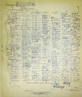
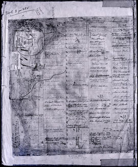
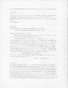
Boxes 7-8 files 91-101-2 (Land and Estate Papers: grants, deeds of land and mortgages and sale of part of a cricket field)
Box 9 files 102-106 (Legal papers: daily journal and legal documents)
Boxes 9-10 files 107-112-4 (Programs and invitations to various programs and events)
Box 10 files 113-117-2 (misc correspondence and newspaper clippings: letters, certificate, and notes)
Box 10 files 118-127 (misc business and other items: reports, letterheads, advertisements, postcards and brochures)
3 red books (The Quarterly Militia List:1897-1900)
small reddish brown book (Infantry Drill by Authority-1889)
2nd larger reddish brown book (Field Artillery Training-1914)
greyish book (The Militia Lists-1886)

Ponton (family)

Results 1 to 20 of 1540