
Marston Minerals of Tweed collection
- CA ON00156 2023-094
- Collection
- 1943-1945
Newspaper clippings and photographs relating to the Marston mica mine in Tweed, Ontario.
Marston Minerals of Tweed collection
Newspaper clippings and photographs relating to the Marston mica mine in Tweed, Ontario.
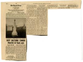
File contains a newspaper article from The Tweed Newsconcerning the disinterment and theft of the body of the late Stephen Conger Johnston and an ensuing controversy involving Kingston medical students in November 1889.

Photograph of students at Victoria School, Tweed
Hastings, Judson Byron

Topographical map of Tweed - Canada sheet
Part of Map collection
A topographical map of Tweed - Canada sheet #31 C/6. Published by the Army Survey Establishment, Department of National Defence in 1933. Scale 1 inch to 1 mile = 1/63,360.
Donated by Gerry Boyce.
Canada. Department of National Defence

Collection of materials relating to Elias Wright life in Tweed, Ontario:
Wright, Elias

Vanderwater Conservation Area Praised by Engineer; Lingham Dam Valuable Asset
Newspaper article concerning Col. Roscoe Vanderwater Conservation Area developed by the Moira River Conservation Authority.
Intelligencer

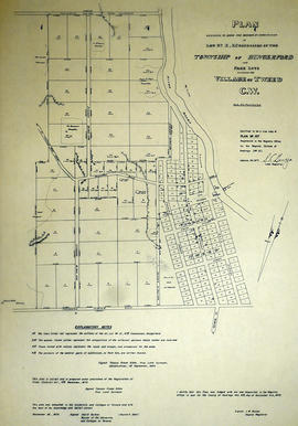
Photocopy of a Plan of the Village of Tweed
Part of Map collection
A photocopy of a Plan of the Village of Tweed, Lots # 11 & 12, Concession X, Hungerford Township. Surveyed by John D. Evans, P.L.S., circa 1870. Scale 3 chains to an inch. Written on the back is "16 x 16 original at Tweed Museum."
Donated by the Belleville Public Library in 2014.
Evans, John Dunlop, P.L.S.

Map of Hastings with the Principal Villages and the City of Belleville
Part of Map collection
A map of Hastings County including the Town of Belleville and other principal villages:
Trenton, Madoc, Marmora, Tweed, Bridgewater, Stirling, Wicklow, Bangor, Herschel, Monteagle, Carl, Dungannon, Wollaston, Limerick, Cashel, Tudor, Grimsthorpe, Elzevir; Rawdon, Huntingdon, Hungerford, Sidney, Thurlow, Tyendinaga.
Scale: 3 miles =1 inch. Published by Evans & Bolger, P. L. Surveyors, P.L.S. in 1879-1880.
Evans and Bolger
Plan of Lot 10 in the village of Tweed
Part of Map collection
A certified reproduction of the "Plan of Lot # 10 in Concession 10 of Hungerford Township into Park Lots adjoining the Village of Tweed C. W." The Village of Tweed depicts: grist mill, saw mill, and on opposite side of River: Fulling & Carding Shop. Surveyed by Thomas Fraser Gibbs, P.L.S., and signed September 1, 1864.
This copy was made in 1972 of plan #157, as registered in the Hastings Land Registry Office.
Donated by Walter I. Watson, O.L.S.
Gibbs, Thomas Fraser, P.L.S.
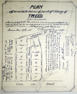
Plan of Lot 11 in the Village of Tweed
Part of Map collection
A certified reproduction of "Plan of re-subdivision of part of village of Tweed...Part of the southwest quarter of the south half of Lot # 11, Concession 10, Township of Hungerford. Laid out for John M. McCaman.” Surveyed by C. Fraser Aylsworth Jr., P.L.S., and signed May 29, 1886.
This copy was made in 1972 of plan #310, as registered in the Hastings Land Registry Office.
Donated by Walter I. Watson, P. L. S.
Aylsworth, Charles Fraser Jr., O.L.S.

Subdivision of Block 60 in the Village of Tweed
Part of Map collection
A certified reproduction of the "Subdivision of Block 60, Tweed, for proprietor James Quinn, witnessed by Stafford Quinn, clerk.” Surveyed by William R. Aylsworth, P.L.S., and signed August 17, 1900.
This copy was made in 1972 of plan #305, as registered in the Hastings Land Registry Office.
Donated by Walter I. Watson, P. L. S.
Aylsworth, William Robert, O. L. S.

Plan of Revision of Lot 10 in the Village of Tweed
Part of Map collection
A certified reproduction of the "Plan of Re-subdivision of part of Lot # 10, Concession 10, Hungerford Township, being in Tweed, for L. E. McPomeroy, owner.” Surveyed by C. Fraser Aylsworth Jr., P.L.S., and signed October 10, 1896.
This copy was made in 1972 of plan #297, as registered in the Hastings Land Registry Office.
Donated by Walter I. Watson, P. L. S.
Aylsworth, Charles Fraser Jr., O.L.S.

Plan of Re-subdivision of Lots 10-11 in the Village of Tweed
Part of Map collection
A certified reproduction of the "Plan of Resubdivision of Part of Lots # 10, 11, Concession 10, Hungerford Township, Adjoining Village of Tweed, for Dr. Timotheus E. Pomeroy.” Surveyed by C. Fraser Aylsworth Jr., P.L.S., and signed August 6, 1890.
This copy was made in 1972 of plan #294, as registered in the Hastings Land Registry Office.
Donated by Walter I. Watson, P. L. S.
Aylsworth, Charles Fraser Jr., O.L.S.
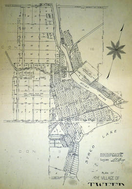
Plan of the Village of Tweed 1891
Part of Map collection
A certified reproduction of the "Plan of the Village of Tweed. Part Lot # 10, Concession 11; Part Lots # 10, 12, Lot # 11, Concession 10 Part of Lot # 11, Concession 9.” Surveyed by C. Fraser Aylsworth Jr. P. L. S., and signed July 26, 1891.
This copy was made in 1972 of plan #284, as registered in the Hastings Land Registry Office.
Donated by Walter I. Watson, P. L. S.
Aylsworth, Charles Fraser Jr., O.L.S.
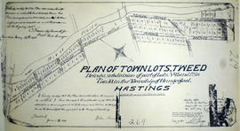
Subdivision of Town Lots 11-12 in the village of Tweed
Part of Map collection
A certified reproduction of the "Plan of Town Lots, Tweed, being a subdivision of Lots # 11 and 12 in Concession 10, Township of Hungerford, for John Alexander.” Surveyed by C. Fraser Aylsworth Jr. P. L. S., and signed May 26, 1888.
This copy was made in 1972 of plan #269, as registered in the Hastings Land Registry Office.
Donated by Walter I. Watson, P. L. S.
Aylsworth, Charles Fraser Jr., O.L.S.

Subdivision of Lots 11-12 in the Village of Tweed
Part of Map collection
A certified reproduction of the "Plan of subdivision in the Village of Tweed, part of Lots # 11 & 12, Concession 10, Township of Hungerford, for James Coleman Jamieson.” Surveyed by John D. Evans, P.L.S., and signed August 14, 1882.
This copy was made in 1972 of plan #228, as registered in the Hastings Land Registry Office.
Donated by Walter I. Watson, P. L. S.
Evans, John Dunlop, P.L.S.

Map of Hastings County in 4 sections
Part of Map collection
A map of Hastings County outlining townships from the Bay of Quinte in the south, to Wallaston, Limerick and Cashel in the north.
Map is in four sections. Scale: 3 miles : 1 inch. Original map is dated 1894. Photocopy from the Archives of Ontario.

Plan of Hastings for Hastings Directory
Part of Map collection
A map of Hastings County outlining townships:
Marmora, Lake, Madoc, Tudor, Grimsthorpe, Elzevir; Rawdon, Huntingdon, Hungerford, Sidney, Thurlow, Tyendinaga - as well as the northern townships.
Inset is "the Village of Marmora." Surveyed by H. A. F. Macleod, C.E. and P.L.S. Published by W. A. Little Lith., Montreal in the 1864-1865 copy of the Hastings Directory . Scale: 1:190,000.
MacLeod, Henry Augustine Fitzgerald, P.L.S.

Lloyd's Map of Hastings County
Part of Map collection
A map of Hastings County outlining the twelve townships:
Marmora and Lake, Madoc, Tudor, Grimsthorpe, Elzevir; Rawdon, Huntingdon, Hungerford, Sidney, Thurlow, Tyendinaga. The northern townships are pictured on the right side.
As well as, the lots and concessions. Circa 1922. Scale: 1.5 miles: 1 inch. Published by Lloyd's Maps, Map Publisher.
Lloyd's Map, Map Publisher

Map of Hastings with townships
Part of Map collection
A map of Hastings County outlining the twelve townships:
Marmora and Lake, Madoc, Tudor, Grimsthorpe, Elzevir; Rawdon, Huntingdon, Hungerford, Sidney, Thurlow, Tyendinaga.
As well as, the lots and concessions. Circa 1916.Scale: 4 miles: 1 inch.
Donated by K.G.M. Ross.