Showing 75 results

Archival description
Map collection Trenton Land, settlement and immigration Image
Print preview Hierarchy View:

75 results with digital objects Show results with digital objects

Burttdale Heights subdivision in Trenton

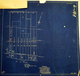
A certified reproduction of the "Burttdale Heights subdivision of Lots # 19 to 28 on East side of Reid Street. Reg'd plan no. 240, Trenton.” The area includes; Lots # 1 to 168, Block A-D, east of Reid Street and south of Hamilton Road, being Lot # 1 Concession 1, Township of Sidney. Surveyed by Ronald Benn, O. L. S. and signed October 14, 1964.

Donated by Walter I. Watson, P. L. S.

Benn, Ronald, O.L.S.

Diagram of Town plot called Trent Port

A copy of an original map by Deputy Provincial Surveyor F. P. Rubidge showing a diagram of a town plot at the mouth of the Trent River called the "Town of Trent Port." Specifically, the map shows Lot 2 near the 1st Concession bordering Murray Township in the County of Northumberland.
Published in Cobourg on September 25, 1852.
Donated by K.G.M. Ross.

Rubidge, Frederick Preston, D.P.S.

Elmwood Acres Subdivision in the Town of Trenton

A certified reproduction of the "Elmwood Acres Subdivision of part Lots # 3 & 4, part of Birch Street...Town of Trenton, County of Hastings.” The area includes; Lots # 1 to 70, west of the Township of Sidney and east of Byron Street, being Lots on Elmwood Drive, Warren Road, Nelles Avenue and Birch Street. Surveyed by John Thomas Ransom, O. L. S. and signed October 8, 1960.

Donated by Walter I. Watson, P. L. S.

Ransom, John Thomas, P.L.S.

Hastings with Town of Belleville and principal villages

A map of Hastings County including the Town of Belleville and other principal villages:

Trenton, Madoc, Marmora, Tweed, Bridgewater, Stirling, Wicklow, Bangor, Herschel, Monteagle, Carl, Dungannon, Wollaston, Limerick, Cashel, Tudor, Grimsthorpe, Elzevir; Rawdon, Huntingdon, Hungerford, Sidney, Thurlow, Tyendinaga.

Scale: 3 miles =1 inch. Published by John P. Evans, P.L.S. in 1869.

Evans, John Dunlop, P.L.S.

Highlands of Hastings, Trenton and Belleville Maps

A map entitled "Highlands of Hastings, Trenton and Belleville," published by the Canada Map Service in honour of Canada's Centennial. Area includes Trenton and Belleville on the front and on the backside west Frankford, east to Hungerford, north to Lake St. Peter and south to the Bay of Quinte. Dated 1966-1967.

Canada Map Service

Hydrographic Map of Plans in Bay of Quinte

A hydrographic map of Plans in the Bay of Quinte, Ontario, Canada. 4 inset maps are included of the 1) Trenton and Approaches, 2) Belleville, 3) [Racist slur redacted] Narrows, and 4) Telegraph Narrows. Nautical surveys completed by Col. W. P. Anderson in 1893 and Mr. E. A. Ghysens in 1934. Map printed March 25, 1952. Published by the Canadian Hydrographic Service, Department of Mines and Technical Surveys, Ottawa.

Canadian Hydrographic Service

Lloyd's Map of Hastings County

A map of Hastings County outlining the twelve townships:
Marmora and Lake, Madoc, Tudor, Grimsthorpe, Elzevir; Rawdon, Huntingdon, Hungerford, Sidney, Thurlow, Tyendinaga. The northern townships are pictured on the right side.
As well as, the lots and concessions. Circa 1922. Scale: 1.5 miles: 1 inch. Published by Lloyd's Maps, Map Publisher.

Lloyd's Map, Map Publisher

Lot Division Map of Sidney Township

A lot division map of Sidney Township in Hastings County, Ontario. Published by the Department of Land Surveys on August 18th, 1944. Scale: 1=4,000.

Bottom right corner reads "Dominion of Canada, War Assets Corporation" and discusses a storage yard location on Lot 3, Concession 1.

Department of Land Surveys

Map of Expropriated Land for Trenton Air Base

A map of Sidney Township, part of Concession #1 and Broken Front, October 18th, 1912. The map details a tract of land expropriated for Trenton Air Base. Scale: 12.5 chains : 1 inch.

Attached is a letter dated May 1st, 1931, The King versus Maitland Hutton and Leda Hutton.

Map of Hastings with the Principal Villages and the City of Belleville

A map of Hastings County including the Town of Belleville and other principal villages:

Trenton, Madoc, Marmora, Tweed, Bridgewater, Stirling, Wicklow, Bangor, Herschel, Monteagle, Carl, Dungannon, Wollaston, Limerick, Cashel, Tudor, Grimsthorpe, Elzevir; Rawdon, Huntingdon, Hungerford, Sidney, Thurlow, Tyendinaga.

Scale: 3 miles =1 inch. Published by Evans & Bolger, P. L. Surveyors, P.L.S. in 1879-1880.

Evans and Bolger

Map of Hastings with townships

A map of Hastings County outlining the twelve townships:
Marmora and Lake, Madoc, Tudor, Grimsthorpe, Elzevir; Rawdon, Huntingdon, Hungerford, Sidney, Thurlow, Tyendinaga.
As well as, the lots and concessions. Circa 1916.Scale: 4 miles: 1 inch.

Donated by K.G.M. Ross.

Map of Lot L on the Trent River

A photostat of a map by from an H. Belden & Company's atlas showing Lot L on the Trent River - 1878.
Donated by K.G.M. Ross in 1963.

H. Belden & Company

Map of Murray Township showing several lots

A copy of an original map by Surveyor General David W. Smith showing several lots of land in Murray Township in the District of Newcastle. Specifically, the map shows Lots 1-5 near the 1st Concession and River Trent. Published by Henry Smith on July 24, 1799.

Donated by K.G.M. Ross in 1963.

Smith, David William

Map of the Town of Trenton 1926

A map of the town of Trenton, Ontario in June 1926. The map features numbered lots, present industries, CNR tracks and other important buildings. Streets and their names, as well as the River Trent are also present. Scale: 1:3000. Composed by Mayor W. A. Fraser and published by his Town Council.

Fraser, William Alexander

Map of the Trent Port

Map showing a sketch of the Trent Port - June 12th, 1837. Scale: 2 chains to an inch. Published by the Office of the Surveyor General.

From the Archives of Ontario in Toronto.

Map of Town Plot at mouth of Trent River

A map of a town plot at the mouth of the Trent River in the Newcastle District. The map features numbered lots, present streets and water ways. Scale: 1 inch = 2 chains. Originally surveyed by F. P. Rubidge, D.P.S., in 1834. This copy was issued September 23, 1926.

Rubidge, Frederick Preston, D.P.S.

Patricia Park Plan in the Town of Trenton

A certified reproduction of the "Patricia Park Plan - part of subdivision of Lot # 1, Concession 2, Murray Township signed by John A. Stevenson; William H. Reid; Hugh Leonard O'Rourke." Surveyed by Evans and Evans Civil Engineers and O.L.S. Plan was signed October 21, 1913.

This copy was made in 1972 of plan #451, as registered in the Hastings Land Registry Office.

Donated by Walter I. Watson, O.L.S.

Evans and Co., Engineers and Surveyors

Plan of Block D in the town of Trenton

A certified reproduction of the "Irvine Block, subdivision of part of Block D, East ½ of Lot # 3 Concession 1, Murray Township, now Town of Trenton, for Honorable George Irvine, of City of Quebec, by his attorney N. B. Falkiner.” Surveyed by William S. Drewry, P.L.S., and dated September 1, 1884.

This copy was made in 1972 of plan #237, as registered in the Hastings Land Registry Office.

Donated by Walter I. Watson, P. L. S.

Drewry, William Stewart, P.L.S.

Plan of Francis Survey of Town Lots in Trenton

A certified reproduction of the Plan of Francis Survey of Town lots, composed of part of Lot # 1 in 1st Concession of Murray Township. Surveyed by John J. Haslett, P.L.S. and signed April5, 1869.

This copy was made in 1972 of plan #122, as registered in the Hastings Land Registry Office.

Donated by Walter I. Watson, O.L.S.

Haslett, John James, P.L.S. & D.P.S.

Plan of Glebe Lots in the village of Trenton

A certified reproduction of the "Plan of Glebe Lots in Village of Trenton, Part of Lot # 2 in 1st Concession of Murray Township for William Bleasdell, Rector of Village of Trenton." Surveyed by Thomas O. Bolger, P. L. S., and signed July 18, 1874.

This copy was made in 1972 of plan #182, as registered in the Hastings Land Registry Office.

Donated by Walter I. Watson, O.L.S.

Bolger, Thomas Oliver, P.L.S.

Results 1 to 20 of 75