A topographical map of Bancroft - Canada sheet #31 F/4, east half. Published by the Army Survey Establishment, Department of National Defence in 1950. Scale 1:50,000.
A topographical map of Bancroft - Canada sheet #31 F/4, west half. Published by the Army Survey Establishment, Department of National Defence in 1950. Scale 1:50,000.
A topographical map of Bancroft - Canada sheet #31 F/4, west half. Published by the Army Survey Establishment, Department of National Defence in 1956. Scale 1:50,000.
A topographical map of Bancroft - Canada sheet #31 F/4, east half. Published by the Army Survey Establishment, Department of National Defence in 1956. Scale 1:50,000.
A topographical map of Bannockburn - Canada sheet #31 C/12. Published by the Army Survey Establishment, Department of National Defence in 1950. Scale one inch to one mile - 1/63,360.
A topographical map of Belleville - Canada sheet #31 C/3, west half. Published by the Army Survey Establishment, Department of National Defence in 1956. Scale 1:50,000.
A topographical map of Belleville - Canada sheet #31 C/3, east half. Published by the Army Survey Establishment, Department of National Defence in 1956. Scale 1:50,000.
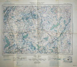
A topographical map of Coe Hill- Canada sheet #31 C/13. Published by the Army Survey Establishment, Department of National Defence in 1949. Scale one inch to one mile = 1/63,360.
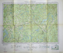
A topographical map of Coe Hill- Canada sheet #31 C/13. Published by the Army Survey Establishment, Department of National Defence in 1950. Scale one inch to one mile = 1/63,360.
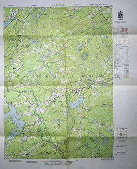
A topographical map of Coe Hill- Canada sheet #31 C/13, west half. Published by the Army Survey Establishment, Department of National Defence in 1956. Scale 1:50,000.
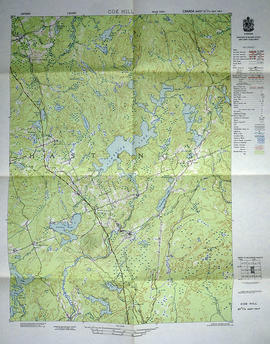
A topographical map of Coe Hill- Canada sheet #31 C/13, east half. Published by the Army Survey Establishment, Department of National Defence in 1956. Scale 1:50,000.
A topographical map of Trenton - Canada sheet #31 C/4. Published by the Army Survey Establishment, Department of National Defence in 1938. Scale one inch to one mile - 1/63, 360.
A topographical map of Tweed - Canada sheet #31 C/6, east half. Published by the Army Survey Establishment, Department of National Defence in 1958. Scale 1:50,000.
A topographical map of Tweed - Canada sheet #31 C/6, west half. Published by the Army Survey Establishment, Department of National Defence in 1958. Scale 1:50,000.
A topographical map of Tweed - Canada sheet #31 C/6. Published by the Army Survey Establishment, Department of National Defence in 1933. Scale 1 inch to 1 mile = 1/63,360.
Photograph taken at John and Leatha Homan's farm on Harmony Road in Corbyville, Hastings County, Ontario. It shows Mike Stanko, a displaced person from Poland who came to Canada after the Second World War, and the Homan's son, Clare, next to a car.
Eleven digital photographs of the demonstration at the railway lines in the Tyendinaga Mohawk Territory in support of the Wet'suwet'en protest against the construction of the Coastal GasLink pipeline through their territory.
A reproduction of an air survey photograph produced by the Ontario Ministry of Natural Resources. Map # 442773E of Sidney Township in Hastings County, Ontario. Circa 1950.
The photograph shows Sidney Township, Concession 1 to 8, Lots # 1 to 25, Hwy 33 and the Trent Canal and Frankford Village, southeast part of Murray Township.
Donated by Walter I. Watson, P. L. S.
Ontario. Ministry of Natural Resources and Forestry
A reproduction of an air survey photograph produced by the Ontario Ministry of Natural Resources. Map # 442773W of Murray Township in Hastings County, Ontario. Circa 1950.
The photograph shows Concession 3 to 10 and Hickory Island of Murray Township, and Lots # 5 to 22, east part of Brighton Township.
Donated by Walter I. Watson, P. L. S.
Ontario. Ministry of Natural Resources and Forestry
A reproduction of an air survey photograph produced by the Ontario Ministry of Natural Resources. Map # 443771W of Tyendinaga Township in Hastings County, Ontario. Circa 1950.
The photograph shows Lonsdale, Melrose and north to Concession 8, Township of Tyendinaga.
Donated by Walter I. Watson, P. L. S.
Ontario. Ministry of Natural Resources and Forestry