Mostrando 40 resultados

Descripción archivística
Rawdon, Township of Land, settlement and immigration
Imprimir vista previa Hierarchy Ver :

27 resultados con objetos digitales Muestra los resultados con objetos digitales

Rawdon Township Map # 444773E

  • CA ON00156 M/M470-2591 - 2616/2603
  • Unidad documental simple
  • c. 1950
  • Parte deMap collection

A reproduction of an air survey photograph produced by the Ontario Ministry of Natural Resources. Map # 444773E of Rawdon Township in Hastings County, Ontario. Circa 1950.

The photograph shows Rawdon Township from the eastern border to Hwy 14, Harold and Springbrook Villages, western Huntingdon Township, southern Marmora and Madoc Townships, Banker Lake.

Donated by Walter I. Watson, P.L.S.

Sin título

Rawdon Township Map # 444773W

  • CA ON00156 M/M470-2591 - 2616/2604
  • Unidad documental simple
  • c. 1950
  • Parte deMap collection

A reproduction of an air survey photograph produced by the Ontario Ministry of Natural Resources. Map # 444773W of Rawdon Township in Hastings County, Ontario. Circa 1950.

The photograph shows Rawdon Township, Concession 8 to 14, west of Hwy 14, small sections of Marmora Township including Marmora Village and Crow Lake and a small part of Seymour Township in Northumberland County

Donated by Walter I. Watson, P.L.S.

Sin título

Hydro-Electric Power Commission of Ontario, Frankford Section

  • CA ON00156 M/M430-2995 - 2996, 3018 - 3021, 3031/3020
  • Unidad documental simple
  • c. 1950
  • Parte deMap collection

An original map produced for the Hydro-Electric Power Commission of Ontario, concerning hydro power lines, stations and transformers. However, the map also features railways, roads and land boundaries.

This map is of the North Section - Frankford Rural Power District. The total area includes parts of Thurlow, Huntingdon, Sidney, Rawdon, Campbellford, Seymour, Brighton, and Percy Townships. Circa 1950.
Donated by David Pershik.

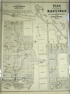
Plan of Hastings for Hastings Directory

  • CA ON00156 M/M420-1080
  • Unidad documental simple
  • 1864-1865
  • Parte deMap collection

A map of Hastings County outlining townships:
Marmora, Lake, Madoc, Tudor, Grimsthorpe, Elzevir; Rawdon, Huntingdon, Hungerford, Sidney, Thurlow, Tyendinaga - as well as the northern townships.
Inset is "the Village of Marmora." Surveyed by H. A. F. Macleod, C.E. and P.L.S. Published by W. A. Little Lith., Montreal in the 1864-1865 copy of the Hastings Directory . Scale: 1:190,000.

Sin título

Map of the Counties of Hastings and Prince Edward

  • CA ON00156 M/M420-1093
  • Unidad documental simple
  • 1898
  • Parte deMap collection

A "Map of the Counties of Hastings and Prince Edward." In 1898, the lots, concessions, churches, schools and mines are shown of the townships in Hastings and Prince Edward. Scale: 1.5 miles to an inch. Published by the Canadian Map Publishing Company in Hamilton, Ontario, for the Belleville Sun. Revised by Henry Carre, C.E. Inset is the map of North Hastings, scale 400 chains to an inch.

Sin título

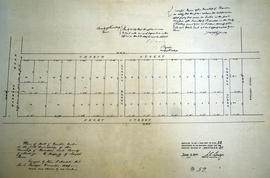
Plan of part of Lot 12 in the Township of Rawdon

  • CA ON00156 M/M430-1744
  • Unidad documental simple
  • Dec 1849
  • Parte deMap collection

A certified reproduction of the Plan of part Lot # 12 in 1st Concession of Rawdon, for proprietor Joseph Green. The lot is bounded by Marmora Road, Church Street. the Line between Concessions 11 & 12 and Front Street. Surveyed by John J. Haslett, P.L.S. and signed in December 1849.

This copy was made in 1972 of plan #52, as registered in the Hastings Land Registry Office.

Donated by Walter I. Watson, O.L.S.

Sin título

Plan of Lot 23 in the village of Rawdon (Stirling)

  • CA ON00156 M/M430-1751
  • Unidad documental simple
  • 1849
  • Parte deMap collection

A certified reproduction of the Plan of part of Rawdon (Stirling) Village, the north end of Lot # 23 in 9th Concession of Rawdon Township. A tannery is by the shore of Rawdon Creek and buildings are on Wright Street and John Street. An “Old Bridge” & a “New Bridge” extend over the Creek. Surveyed by John J. Haslett, P.L.S. in 1849.

This copy was made in 1972 of plan #54, as registered in the Hastings Land Registry Office.

Donated by Walter I. Watson, O.L.S.

Sin título

Rawdon Township Council, 1957

File contains several newspaper clippings concerning the election of the Rawdon Township Council, and minutes of its meetings, 1957. Also present is a photocopied excerpt of the Hastings County Directory, 1860-1861, and 1864-1865 with statistics for Rawdon Township including names of property owners listing occupations, and location of properties by lot and concession number.

Hubel, Sarah, 1880

File contains a typescript transcript concerning the life of Sarah Ruth Hubel[sic], b. 1792, daughter of Loyalist Nehemiah Hubel[sic]. Includes references to Rawdon Township in the period of the the War of 1812.

Willson, John Metcalfe - Papers

File contains original documents, presented to the Hastings County Historical Society in 1960; Biographical sketch written on 22-September-1869 covers the years 1862 to 1869 when Willson was teaching school in the southern part of Hastings County; educational papers; legal papers; correspondence and a poem entitled "To The Mohawks".

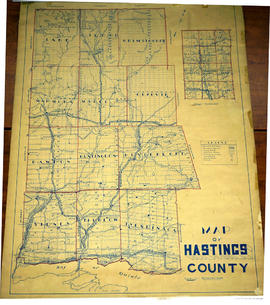
Lloyd's Map of Hastings County

  • CA ON00156 M/M420-1139
  • Unidad documental simple
  • c. 1922
  • Parte deMap collection

A map of Hastings County outlining the twelve townships:
Marmora and Lake, Madoc, Tudor, Grimsthorpe, Elzevir; Rawdon, Huntingdon, Hungerford, Sidney, Thurlow, Tyendinaga. The northern townships are pictured on the right side.
As well as, the lots and concessions. Circa 1922. Scale: 1.5 miles: 1 inch. Published by Lloyd's Maps, Map Publisher.

Sin título

Plan of park lots on Lots 10-11 in Rawdon Township

  • CA ON00156 M/M430-1777
  • Unidad documental simple
  • Sep 1853
  • Parte deMap collection

A certified reproduction of the Plan of Park Lots on the north part of Lot # 10 and east half of Lot # 11 in the 1st Concession of Rawdon Township, adjoining to town of Stirling. Property of Edward Fidlar. Surveyed by John Emerson, P.L.S. in September 1853.

This copy was made in 1972 of plan #38, as registered in the Hastings Land Registry Office.

Donated by Walter I. Watson, O.L.S.

Sin título

Rawdon Township : History of Springbrook

File contains a handwritten essay by Florence McKeown and Ida Smith both from Springbrook regarding the history of Springbrook community ca. 1838 to 1965. Includes information on roads, local industry, churches, schools and a brief account of the cheese factories and local families

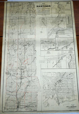
Map of Hastings with the Principal Villages and the City of Belleville

  • CA ON00156 M/M420-1088
  • Unidad documental simple
  • 1879-1880
  • Parte deMap collection

A map of Hastings County including the Town of Belleville and other principal villages:

Trenton, Madoc, Marmora, Tweed, Bridgewater, Stirling, Wicklow, Bangor, Herschel, Monteagle, Carl, Dungannon, Wollaston, Limerick, Cashel, Tudor, Grimsthorpe, Elzevir; Rawdon, Huntingdon, Hungerford, Sidney, Thurlow, Tyendinaga.

Scale: 3 miles =1 inch. Published by Evans & Bolger, P. L. Surveyors, P.L.S. in 1879-1880.

Sin título

Map of Hastings with townships

  • CA ON00156 M/M420-1101
  • Unidad documental simple
  • c. 1916
  • Parte deMap collection

A map of Hastings County outlining the twelve townships:
Marmora and Lake, Madoc, Tudor, Grimsthorpe, Elzevir; Rawdon, Huntingdon, Hungerford, Sidney, Thurlow, Tyendinaga.
As well as, the lots and concessions. Circa 1916.Scale: 4 miles: 1 inch.

Donated by K.G.M. Ross.

Resultados 1 a 20 de 40