Showing 263 results

Archival description
Thurlow, Township of Item
Print preview Hierarchy View:

178 results with digital objects Show results with digital objects

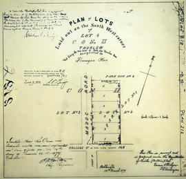
Additions to Taylor's Plan of George Street in Belleville

A certified reproduction of "Taylor's Plan of George Street (added to the plan by John Emerson, P. L. S.) by Samuel M. Benson, P. L. S. on north 40 feet of Lot # 45 to access Adam Street from road between Lots # 8 & 9 in 2nd Concession Thurlow for George Taylor." Signed August 25, 1874.

This copy was made in 1972 of plan #175, as registered in the Hastings Land Registry Office.

Donated by Walter I. Watson, O.L.S.

Benson, Samuel Manson, D.P.S. & P.L.S.

Alternative Hydro Routes from Lennox to Oshawa

A map studying alternative routes for hydroelectric power. The area covers from West Oshawa, East Mount Pleasant Jct. North Rice Lake & South Lake Ontario.

Commonwealth Associates Inc.

Boundary Lines Survey of Thurlow

A certified reproduction of the “Boundary Line Commissioners Survey, Concession 1, Township of Thurlow, for the Victoria District.” The area contained includes; Thurlow Township, Concession 1, Lots # 5 to 31 and the Tyendinaga Mohawk Territory on the Southerly part of Lots # 28, 29, 30, 31 along the bayshore. Originally surveyed by John Emereson, P. L. S. and produced on December 27, 1841. This reproduction was made on June 5, 1972.

Donated by Walter I. Watson, P. L. S.

Emerson, John, P.L.S.

Cannifton & The Holgate Family

This file contains a personal writing by Maribeth L. Bird of Belleville, dated 1983 and titled "Cannifton, The Seat of Thurlow Township, Hastings County, Ontario, Canada". It contains: a brief history of Cannifton and the people; several reproduced articles from the Intelligencer (death of a child, Clarence William Holgate), unveiling of a plaque in memory of Miss Mary Cowan, "Reminiscent of a Mark Twain Novel" by John Bateman. The majority of the book is a family genealogy starting with John and Mary Holgate, born in England and Scotland in the years 1791 and 1797. The family history also contains photocopies of family pictures.

Bird, Maribeth Lillian

Commercial Bank Subdivision of Lots 11-19 in Belleville

A certified reproduction of the "Commercial Bank Plan of subdivision of Lots # 11, 12, 13, 14, 15, 16, 17 and 19, of Belleville, being part of Lot # 2 Concession 1 Thurlow." Surveyed by John D. Evans, P.L.S., and dated April 18, 1873.

This copy was made in 1972 of plan #160, as registered in the Hastings Land Registry Office.

Donated by Walter I. Watson, O.L.S.

Evans, John Dunlop, P.L.S.

Corporation of Thurlow Map of Roads

A map from the Corporation of the Township of Thurlow showing Ontario Hydro lines, concessions and additional country roads. Circa 1970.
Donated by the City of Belleville.

East Gate Subdivision in the City of Belleville

A certified reproduction of the "Subdivision of Part of East ½ of Lot # 13, Concession 1, Township of Thurlow, now Belleville laid out for Maple View Realty Ltd. Pres. Maurice Rollins.” The area includes; Lots # 1 to 110 and Blocks A, B, C, D, E, F and Haig Road, Joyce Crescent, Richmond Grove, Janlyn Crescent, Whalen Court, all east of Haig Road. Surveyed by Walter I. Watson, O. L. S. and signed February 10, 1964.

Donated by Walter I. Watson, P. L. S.

Watson, Walter Irvine, O.L.S.

East Park Subdivision in the City of Belleville

A certified reproduction of the "East Park Subdivision, part of east half of Lot # 13, Concession 1, formerly Township of Thurlow, now Belleville - owner Lambert Rollins Construction.” The area includes; Lots # 1 to 47, Block A-C, east of Haig Road, with Bridge Street East, Joyce Crescent, Freemont Road. Surveyed by T. S. Ransom O. L. S. (of Ransom & Watson, O. L. S.) and signed April 21, 1965.

Donated by Walter I. Watson, P. L. S.

Ransom, Thomas Saunders, P.L.S.

Eastview Heights Subdivision in the City of Belleville

A certified reproduction of the "Subdivision Eastview Heights, part of Lot # 13, Concession 1, Township of Thurlow now City of Belleville.” The area includes; north of Victoria Avenue being Lots # 1 to 25, Blocks A-B laid out on Edge Hill Road, Kingsway Court, Victoria Avenue, and Haig Road. Surveyed by Thomas S. Ransom, O. L. S. and signed May 17, 1963.

Donated by Walter I. Watson, P. L. S.

Ransom, Thomas Saunders, P.L.S.

Education: South Hastings S.S. 20 Thurlow

File contains a manuscript register for School Section 20, Thurlow Township for 1880-1901. Also present is a circular letter dated September 1, 1921 from H.J. Clarke, Public School Inspector, Hastings County, to Hastings County teachers concerning registers to be maintained by teachers, teacher's conventions and related administrative matters.

Elmwood Burial Ground in the Township of Thurlow

A certified reproduction of the "Elmwood Burial Ground on Lot # 6, Concession 4, Thurlow Township designed & subdivided by – Engelhardt Landscape Gardener and adopted by Thomas O. Bolger, P. L. S. (certified by Caleb Reid)." Dated December 18, 1874.

This copy was made in 1972 of plan #181, as registered in the Hastings Land Registry Office.

Donated by Walter I. Watson, O.L.S.

Bolger, Thomas Oliver, P.L.S.

Extensions to Reid Cemetery in the Township of Thurlow

A certified reproduction of the "Extensions to Reid Cemetery, Thurlow Township, part of Lot # 6, 4th Concession.” Surveyed by Fred W. Wilkins, O. L. S. of Evans & Evans, Civil Engineers & Ontario Land Surveyors. Signed August 3, 1918.

This copy was made in 1972 of plan #572, as registered in the Hastings Land Registry Office.

Donated by Walter I. Watson, P. L. S.

Wilkins, Frederick William Baiden, O.L.S.

Finnegan Plan of Lots in the Township of Thurlow

A certified reproduction of the "Finnegan Plan - Lots laid out on the southwest corner of Lot # 4, Concession 2, Thurlow and being the west part of Park Lot # 1, for Michael Finnegan.” Surveyed by Evans and Bolger, P. L. S. and dated March 14, 1879.

This copy was made in 1972 of plan #212, as registered in the Hastings Land Registry Office.

Donated by Walter I. Watson, P. L. S.

Evans and Bolger

Floyd Ray's Farm

This file contains a copy of a school project written by Lana Ray from Foxboro Sr. Elementary School. It is titled Floyd Ray's Farm and contains information about the history of the farm owned by Floyd Andrew Ray (Lot 19, 7th Concession, Township of Thurlow) purchased from the Outwaters family circa 1867.

Forest Hill Subdivision in the Township of Thurlow

A certified reproduction of the "Forest Hill Subdivision of Part East ½ Lot # 11, Concession 1 Township of Thurlow, prepared for Barbara MacDonell.” The area includes; east of Farley Avenue, from Bridge Street East north to Pine Street, being the east half of Lot # 11, Concession 1, Thurlow Township. Surveyed by John T. Ransom, O. L. S. and signed November 8, 1956.

Donated by Walter I. Watson, P. L. S.

Ransom, John Thomas, P.L.S.

Results 1 to 20 of 263