Copies of plans of Belleville to Point Anne railway
- CA ON00156 2017-55
- Collection
- 1903-1904
Photocopy of a 1903 profile and a 1904 plan of the Belleville and Point Anne railway (originals at the Archives of Ontario: RG 1-502-0-0-156 and 180).
116 results with digital objects Show results with digital objects
Copies of plans of Belleville to Point Anne railway
Photocopy of a 1903 profile and a 1904 plan of the Belleville and Point Anne railway (originals at the Archives of Ontario: RG 1-502-0-0-156 and 180).
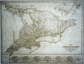
Copy of a Map of the Province of Ontario showing Railways
Part of Map collection
A reproduction of a "Map of the Province of Ontario Showing Railways now Running." A series of Toronto business advertisements line the bottom of the map. Originally published by the Canadian Almanac in 1884. Reproduced by COPP Clark Professional in January 1997 for the celebration of 150 continuous years of almanac and directory publishing.
Donated by the Belleville Public Library in 2014.
Copp Clark Limited
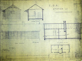
COR Station at Bannockburn Plans
Part of Map collection
A blueprint planning the COR station at Bannockburn, Hastings County, Ontario. Plan features floor, platform plans, elevation and sections. Drawn by John Dunlop Evans, Chief Surveyor/Engineer - July 19, 1902.
Evans, John Dunlop, P.L.S.

COR Station at Bloomfield Plans
Part of Map collection
A blueprint planning the COR passenger station at Bloomfield, Hastings County, Ontario. Plan features floor, platform plans, elevation and sections. Drawn by John Dunlop Evans, Chief Surveyor/Engineer - July 24, 1909.
Evans, John Dunlop, P.L.S.
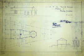
Part of Map collection
A blueprint planning the COR Bancroft extension station at Ormsby junction, Hastings County, Ontario. Plan features floor, elevation and sections. Drawn by John Dunlop Evans, Chief Surveyor/Engineer - September 1, 1900.
Evans, John Dunlop, P.L.S.
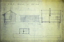
Part of Map collection
A blueprint planning the COR station at St. Ola, Hastings County, Ontario. Plan features floor, elevation and sections.
Corby's cattle boat – Trip to England 1891
File contains a retelling of a Corbyville boy traveling on a cattle boat to England in 1891.

Cornell family photograph album
Photographs taken by members of the Cornell family of 47 John Street in Belleville, Ontario. Family snapshots, photographs of boats in Belleville Harbour, Presqu'ile lighthouse, cars, Billy Bishop's float plane.
Correspondence: Inspector Colonization Roads & County Crown Attorney Belleville 1929
File contains a letter dated 17-April-1929 from W.E. Wiggins, Inspector Colonization Roads Hastings County (Bancroft) to B.C. Donnan, County Crown Attorney, Belleville.
Counties from Belleville to Ottawa
Part of Map collection
A map showing counties from Belleville to Ottawa, Ontario, 1887. Published and donated by S.R.G. Penson.
Received from the Archives of Canada's map collection - 27 Jul. 1966.
Penson, S. R. G.
Covered Bridge at Trenton, Ontario
The file contains a booklet titled "The Covered Bridge at Trenton", published on the occasion of Trenton's centennial as a town, 1880-1980.

Croydon's Map of the City of Belleville
Part of Map collection
A map of the City of Belleville, circa 1932, showing railroads, streets, bus roues, city limits and highways. Also featured is a street index. Published by the Croydon Map Company and drawn excursively for the Rural Township Map Company.
Donated by the Belleville Public Library in 2014.
Croydon Publishing Co.
Customs Commission – W. Webster 1879
File contains the 1879 commission appointing William Webster of Belleville as a Collector in Her Majestys Customs.
File contains an 1845 customs commission for the Port of Belleville.
File contains an “Ontario Homes & Living” magazine story about Ontario's oldest road, the Danforth.
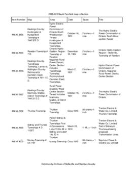
David Pershick collection of railway maps and plans
Ontario Hydro maps for parts of Hastings County and copies of Grand Trunk Railway plans from Library and Archives Canada. Includes a photograph of Canadian National Railway employees at Belleville, Ontario (online at https://www.flickr.com/photos/cabhc/39400300370/) and booklet C.T. 405 from Penn Central with "Special Instructions Governing Operation of Signals and Interlockings", 1968
Three additional Hydro maps were added from David Pershick's estate in January 2024 (2024-007/1-3), with two aerial photographs of railway yards in Toronto (2024-007/4-5, in poor condition).
Pershick, David
Deseronto – Petition for Electric Power 1910
File contains a letter to George P. Graham, Minister of Railways & Canals petitioning for electric power in Deseronto.
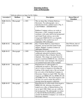
Deseronto Archives photographic collection
The photographs are arranged by subject matter and cover activities in and around the town of Deseronto, Ontario. The majority date from the late nineteenth century and many depict the lumber-related industries of the Rathbun Company in Deseronto. There are also photographs of school groups, churches, railways, First World War airfields and portraits of Deseronto citizens.
Deseronto Catalogue of papers in file 1844-1920 “L”
File contains various papers from the Custom House of Napanee and Deseronto from 1875-1887.
Deseronto Customs – Coasting License 1874
File contains a coasting license granted to John Shaw of Colburn in 1874.