Mostrar 341 resultados

Descrição arquivística
Thurlow, Township of
Previsualizar a impressão Hierarchy Ver:

185 resultados com objetos digitais Mostrar resultados com objetos digitais

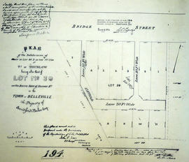
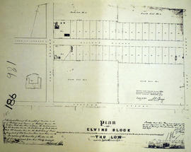
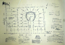
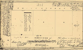
Plan of Subdivision of Lot 39 in the Township of Thurlow

A certified reproduction of the "Subdivision of Lot # 39 according to plan of Lot # 5 laid out on Lot # 6 in 1st Concession of Thurlow by Edmund Murney, situated on southeast corner of Alison [Albion] and Emily Streets.” Surveyed by George A. Simpson, P. L. S. and signed October 10, 1876.

This copy was made in 1972 of plan #201, as registered in the Hastings Land Registry Office.

Donated by Walter I. Watson, P. L. S.

Sem título

Plan of McCreary Block in the Township of Thurlow

A certified reproduction of the "Plan of McCreary Block, part of Park Lot # 3, west side of Park Street. Laid out on Lot # 4 Concession 2 Thurlow for John Thomas McCreary.” The block includes land along North Front Street on the east side and on both sides of Craig Street with eastern boundary at North Park Street. Surveyed by Evans and Bolger, P. L. S. and signed April 21, 1876.

This copy was made in 1972 of plan #200, as registered in the Hastings Land Registry Office.

Donated by Walter I. Watson, P. L. S.

Sem título

Plan of Baker's Block in the Town of Belleville

A certified reproduction of the "Plan of subdivision of part of Lot # 3 in 1st Concession Thurlow, being part of Lot # 39 on south side of Bridge Street in Belleville. Property of Sandford Baker and designated Baker's Block.” Surveyed by John D. Evans, P. L. S. Plan registered October 30, 1875.

This copy was made in 1972 of plan #194, as registered in the Hastings Land Registry Office.

Donated by Walter I. Watson, P. L. S.

Sem título

Plan of subdivision of part of late George Bleecker Estate

A certified reproduction of the "Plan of the subdivision of part of Estate of Late George Bleecker being part of east half of Lot # 7, Concession 1, Thurlow, now Belleville..." The total area surveyed includes north from the Bay of Quinte to Pine Street and the west side of MacDonald and both sides of Dufferin Avenue. Surveyed by Evans and Bolger, P. L. S. and signed June 26, 1878.

This copy was made in 1972 of plan #211, as registered in the Hastings Land Registry Office.

Donated by Walter I. Watson, O.L.S.

Sem título

Plan of part of the property of the late Tobias Bleecker

A certified reproduction of the "Plan of part of the Property of the late Tobias Bleecker, being part of the west half of Lot # 7 in the 1st Concession, Thurlow. Designated “The Trustees Plan” by A.G. Northrup, Thomas Wills, Nelson Lingham, Trustees." The total area surveyed includes the west half of Lot # 7 in the 1st Concession, Thurlow, now Belleville, being both sides of Bleecker Avenue from the north side of Dundas Street to the Railway Station. Surveyed by John Dunlop Evans, P. L. S. and signed January 10, 1874.

This copy was made in 1972 of plan #166, as registered in the Hastings Land Registry Office.

Donated by Walter I. Watson, O.L.S.

Sem título

Subdivision of Lots 5-7 in west Cannifton

A certified reproduction of the "Plan shewing subdivisions of Lots # 5, 6 & 7 in 3rd Concession, Thurlow, west side of River Moira, formerly the property of the late Daniel Canniff in 1856." It was redesignated as “West Cannifton" by Jonas Canniff on August 9, 1862. Surveyed by Publius V. Elmore, P. L. S. Certified by John J. Haslett, P.L. S.

This copy was made in 1972 of plan #124, as registered in the Hastings Land Registry Office.

Beyond the bridge over River Moira and northerly are large lots named: 1. Elizabeth A. Ketchepaw; 2. Letty S. Belch; 3. Thomas Canniff; 4. Philean Canniff; 5. Nancy Canniff; 6. Daniel Canniff; 7. Sarah Mormon; 8. Anne Maria Burnes; 9. Catharine Brown.

Sem título

Plan of Gordon Block in the Town of Belleville

A certified reproduction of the "Plan of Gordon Block - on [the] west side of North Front Street on Lot # 11 (on Coleman's Plan) and being part of Lot # 3 in Concession 1, Thurlow, now Belleville, laid out for R. Gordon.” The block is on bounded by Coleman Street in the west, Harriet Street in the north, North Front Street on east and in the south by Moira Street West. Surveyed by John J. Haslett, P. L. S. and signed November 24, 1873.

This copy was made in 1972 of plan #190, as registered in the Hastings Land Registry Office.

Donated by Walter I. Watson, P. L. S.

Sem título

Plan of Glass Block in the Township of Thurlow

A certified reproduction of the "Plan of Glass Block on the north side of Bridge Street [West] and being part of Lot # 3, Concession 1, Township of Thurlow, now Belleville, for James Glass.” The block is on bounded by Isabel Street in the west, Jane Street in the north, Everitt Street on east and in the south by Bridge Street West. Surveyed by Evans and Bolger, P. L. S. and signed June 1875.

This copy was made in 1972 of plan #189, as registered in the Hastings Land Registry Office.

Donated by Walter I. Watson, P. L. S.

Sem título

Plan of part of the Yeomans Estate in the Township of Thurlow

A certified reproduction of the "Plan of part of the Yeomans Estate - “Yeomans Block” - on Lot # 1, Concession 1, Thurlow and lying North of Moira Street in Belleville, for Horace Yeomans, John Lewis & James Ross, executives of Asa Yeomans.” The total area surveyed includes Sidney Street on the west side, College Street in the north, Frank Street in the east and Moira Street West in the south. Surveyed by Evans and Bolger, P. L. S. Plan registered in August 1875.

This copy was made in 1972 of plan #187, as registered in the Hastings Land Registry Office.

Donated by Walter I. Watson, P. L. S.

Sem título

Plan of Elvins Block in the Township of Thurlow

A certified reproduction of the "Plan of Elvins Block, being Park Lots # 2 on [the] east side of Park Street and west side of James Street, composed of part of Lots # 4 - 5 in 2nd Concession, Thurlow for Richard Elvins.” The total area surveyed includes both sides of College Avenue [Donald Street] between [North] Park Street and James Street [Prince of Wales Drive]. Albert College is pictured. Surveyed by John. J. Haslett, P. L. S. Plan registered on June 14, 1875.

This copy was made in 1972 of plan #186, as registered in the Hastings Land Registry Office.

Donated by Walter I. Watson, P. L. S.

Sem título

Plan of Burrell Block in the Township of Thurlow

A certified reproduction of the "Burrell Block - 5 small lots - on Lot # 1 on southeast side of the road leading to Concession 2, Thurlow, belonging to Ellis Burrell. Being part of Lots laid out by J. J. Haslett, P.L.S . for late Edmund Murney on part of Lot # 6 in Concession 1 Thurlow.” Surveyed by Samuel Manson Benson, P. L. S. & D.P.S. and signed October 14, 1874.

This copy was made in 1972 of plan #185, as registered in the Hastings Land Registry Office.

Donated by Walter I. Watson, P. L. S.

Sem título

Subdivision of part Lots 8-9 in the Township of Thurlow

A certified reproduction of the "Subdivision [of] part east and west halves of Lot # 8 and west half Lot # 9... First Concession, Township Thurlow.” The total area surveyed includes; King's Highway (Highway 2) north to Bridge Street East. Surveyed by John T. Ransom, O. L. S. and signed April 11, 1949.

This copy was made in 1972 of plan #809, as registered in the Hastings Land Registry Office.

Donated by Walter I. Watson, P. L. S.

Sem título

Subdivision of part Lots 8-9 in the Township of Thurlow

A certified reproduction of the "Subdivision [of] part east and west halves of Lot # 8 and west half Lot # 9... First and Broken Front Concession, Township Thurlow.” The total area surveyed includes; east of MacDonald Avenue and between C. P. R. right of way and the Kings Highway (Highway 2), including both sides of Sixth Street. Surveyed by John T. Ransom, O. L. S. and signed July 25, 1949.

This copy was made in 1972 of plan #812, as registered in the Hastings Land Registry Office.

Donated by Walter I. Watson, P. L. S.

Sem título

Subdivision of Lots 5-7 in the Township of Thurlow

A certified reproduction of the "Subdivision [of] Lot # 6 and part Lot # 5 east of North James Street, Lot # 7 and part of Lots # 5 and 6 west of Moira Street according to Reg'd Plan No. 103, Township of Thurlow.” The total area surveyed includes; North James Street (now Prince of Wales Drive) and east to Moira Street East, both sides of Elvins Street and Gardens. Surveyed by John T. Ransom, O. L. S. and signed July 26, 1949.

This copy was made in 1972 of plan #815, as registered in the Hastings Land Registry Office.

Donated by Walter I. Watson, P. L. S.

Sem título

Plan of Subdivision of Lot 17 in the Township of Thurlow

A certified reproduction of the "Plan of Subdivision of part of East half of Lot # 17, Concession 1, Township of Thurlow. Prepared for Dept. of Veteran's Affairs.” The area surveyed includes; part of East 1/2 of Lot # 17, Concession 1, North of C. P. Railway being 32 Lots.
Surveyed by W. J. Pattison, O. L. S. and signed March 24, 1954.

This copy was made in 1972 of plan #944, as registered in the Hastings Land Registry Office.

Donated by Walter I. Watson, P. L. S.

Sem título

Subdivision of Lots 8-9 in the Township of Thurlow

A certified reproduction of the "Subdivision of part of East half Lot # 8 and part West half Lot # 9 in Concession 1, Township of Thurlow now City of Belleville.” The area includes; east of Stanley Street, Lots # 1, 2, 3 & 4 north of Russell Street and north to Station Street.
Surveyed by John Thomas Ransom, O. L. S. and signed July 7, 1952.

This copy was made in 1972 of plan #890, as registered in the Hastings Land Registry Office.

Donated by Walter I. Watson, P. L. S.

Sem título

Subdivision of Part Lot 34 in the Township of Thurlow

A certified reproduction of the "Plan of subdivision of Part Lot # 34, Reg'd Plan No. 65, Township of Thurlow.” The area surveyed includes; Lots east of Herchimer Avenue and north of Bridge Street East, including Eleanor Gardens, being part of Lot # 34 in Thurlow Township. Surveyed by John T. Ransom, O. L. S. and signed October 22, 1954.

This copy was made in 1972 of plan #950B, as registered in the Hastings Land Registry Office.

Donated by Walter I. Watson, P. L. S.

Sem título

Subdivision of Part Lot 12 in the Township of Thurlow

A certified reproduction of the "Plan of Subdivision of Part Lot # 12, Reg. Plan No. 65, Township of Thurlow, owners Donald Brook & Martha E. Brook.” The area surveyed includes; west of Herchimer Avenue and 18 Lots on both sides of Southview Avenue. Surveyed by John T. Ransom, O. L. S. and signed January 10, 1955.

This copy was made in 1972 of plan #980, as registered in the Hastings Land Registry Office.

Donated by Walter I. Watson, P. L. S.

Sem título

Plan of Survey of part Lots 7-8 in the Township of Thurlow

A certified reproduction of the "Plan of Survey of part Lots # 7 & 8, Reg. Plan No. 65, Township of Thurlow.” The area surveyed includes; west of Herchimer Avenue, Lots on both sides of Crestview Avenue and both sides of Rosewood Avenue. Surveyed by John T. Ransom, O. L. S. and signed March 1, 1955.

This copy was made in 1972 of plan #984, as registered in the Hastings Land Registry Office.

Donated by Walter I. Watson, P. L. S.

Sem título

Subdivision of Lots 6-8, 16-18 in the Township of Thurlow

A certified reproduction of the "Plan of Survey of Lots # 6, 7, 17, & 18 and part Lots # 8 & 16. Reg. Plan 217, Township of Thurlow. Owners - M. E. Reid & Lena R. Reid of Woodland Acres Co-Operative Ltd.” The area surveyed includes; land between Bridge Street East, and Victoria Avenue, being west of Farley Avenue. Surveyed by John T. Ransom, O. L. S. and signed March 1, 1955.

This copy was made in 1972 of plan #985, as registered in the Hastings Land Registry Office.

Donated by Walter I. Watson, P. L. S.

Sem título

Resultados 121 a 140 de 341