Showing 813 results

Archival description
Item Land, settlement and immigration Image
Print preview Hierarchy View:

813 results with digital objects Show results with digital objects

Map of Grimsthorpe Township

  • CA ON00156 M/M420-2169 - 2183/M420-2174
  • Item
  • 22 Feb 1867
  • Part of Map collection

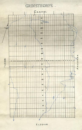
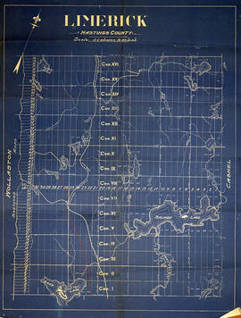
A blueprint reproduction of a map of Grimsthorpe Township in Hastings County, Ontario. The map features the names of neighboring townships, lot and concession numbers, rivers, and lakes. The total area is 69, 028 acres and without lakes 68, 711 acres. Surveyed by William Murdock, P.L.S., and signed February 22, 1867. Scale 40 chains to an inch.

Murdoch, William, P.L.S.

Map of Grimsthorpe Township

  • CA ON00156 M/M420-2169 - 2183/M420-2173
  • Item
  • c. 1860
  • Part of Map collection

An original map of Grimsthorpe Township in Hastings County, Ontario. The map features the names of neighboring townships, lot and concession numbers, Stony Lake, Wolf Lake and rivers. Circa 1860.

Map of Hastings County

A map of Hastings County with major roads, settlements, waterways and railroads. Circa 1930. Portions of adjoining counties are also shown.

Donated by Nick January in 2016.

Map of Hastings County and Townships

A map outlining Hastings County and the townships within. Neighboring counties are also present: Peterborough, Northumberland, Haliburton, Renfrew and Lennox and Addington. The Quinte region, including the cities of Belleville and Trenton are outlined at the bottom of the map.

Map of Hastings County in 4 sections

A map of Hastings County outlining townships from the Bay of Quinte in the south, to Wallaston, Limerick and Cashel in the north.
Map is in four sections. Scale: 3 miles : 1 inch. Original map is dated 1894. Photocopy from the Archives of Ontario.

Map of Hastings County with New Road System

  • CA ON00156 M/M420-2163
  • Item
  • 1914 - 1 Jul 1925
  • Part of Map collection

A map of Hastings County, with its 24 townships, in 1914. Superimposed on top is the New Road System as of July 1, 1925. The map features lots, concessions, locks, settlements, water ways and railroads. Published by the Office of Public Roads & Highways of Ontario.

Donated by Nick January of the Hastings County Planning and Development Department in 2016.

Office of Public Roads and Highways

Map of Hastings with the Principal Villages and the City of Belleville

A map of Hastings County including the Town of Belleville and other principal villages:

Trenton, Madoc, Marmora, Tweed, Bridgewater, Stirling, Wicklow, Bangor, Herschel, Monteagle, Carl, Dungannon, Wollaston, Limerick, Cashel, Tudor, Grimsthorpe, Elzevir; Rawdon, Huntingdon, Hungerford, Sidney, Thurlow, Tyendinaga.

Scale: 3 miles =1 inch. Published by Evans & Bolger, P. L. Surveyors, P.L.S. in 1879-1880.

Evans and Bolger

Map of Hastings with townships

A map of Hastings County outlining the twelve townships:
Marmora and Lake, Madoc, Tudor, Grimsthorpe, Elzevir; Rawdon, Huntingdon, Hungerford, Sidney, Thurlow, Tyendinaga.
As well as, the lots and concessions. Circa 1916.Scale: 4 miles: 1 inch.

Donated by K.G.M. Ross.

Map of Hastings, Frontenac, Lennox and Addington 1850 reprint

Map showing Counties of Hastings, Frontenac, Lennox and Addington and the townships within. Legend shows boundaries of counties and townships, plank and graveled roads, other roads and canals. Surveyed by W. H. Smith. Published by MacLear. Scale 5 miles : 2 cm. Reprinted map from “Canada”: Past, Present, and Future. Original map dated 1850.

Smith, W. H.

Map of Ketcheson Ward

A map of the Ketcheson Ward in Belleville, Ontario. Streets and lots are outlined and named, as well as the River Moira. Scale: 1" = 1 chain. Circa 1870.

Written in ink on cotton.

Map of Kingston to Ottawa

A map of Kingston to Ottawa, Ontario published by the National Development Bureau's Department of the Interior, circa 1930. The map features locks, bridges, waterways and settlements. Scale 2 miles to an inch. Written on the back, in ink, is "canoe trip." Presumably a tool of direction for someone's voyage.

Donated by the Belleville Public Library in 2014.

Canada. Department of the Interior

Map of Lake Township in Hastings County

A map of Lake Township in Hastings County showcasing the mining industry in Eastern Ontario. Concessions and lots are numbered. Plan number E. O. 57 from the Ontario Department of Mines, issued May 6, 1954. Scale: 1:30,000.

Ontario. Department of Mines

Map of Limerick Township

  • CA ON00156 M/M420-2169 - 2183/M420-2180
  • Item
  • c. 1880
  • Part of Map collection

A blueprint reproduction of a map of Limerick Township in Hastings County, Ontario. The map features the names of neighboring townships, lot and concession numbers, creeks, lakes (Salmon, Bass, Mud, etc.), and the Central Ontario Railway. The Hastings Road borders the west side of the township. Original map circa 1880. Scale 40 chains to an inch.

Map of Lot 7 on Coleman Block in the town of Belleville

A certified reproduction of the Map of Lot # 7 - Coleman Block, Belleville. Block bounded by Coleman, Earl, North Front & Harriett Streets, and lying in Lot # 3 in 1st Concession of Thurlow. Surveyed by William Wallbridge, P.L.S. and signed April 9, 1867.

This copy was made in 1972 of plan #117, as registered in the Hastings Land Registry Office.

Donated by Walter I. Watson, O.L.S.

Wallbridge, William, P.L.S.

Map of Lot L on the Trent River

A photostat of a map by from an H. Belden & Company's atlas showing Lot L on the Trent River - 1878.
Donated by K.G.M. Ross in 1963.

H. Belden & Company

Map of Lots 1-19 in Madoc Township

A original plan of Lots 1 to 19 on Concessions 4 to 7 in Madoc Township, with proprietor names on Lots # 8 to 19 on Concessions 8 to 19. The plan is undated, however the proprietors match those of Belden's 1878 Atlas.

The village of Madoc is located at the south. On the left side is presumably part of a legend regarding land use.

Donated by the Glanmore National Historic Site in 2016.

Map of Lower Canada or Canada East

A "Map of Canada East or Lower Canada [with the counties and townships] compiled from Government and Plans, Original Documents and Observations." Published by Maclear and Company of Toronto in 1856. Inset is the townships on the Ottawa River. Scale 22 miles to an inch.

Donated by the Glanmore National Historic Site in 2016.

Maclear and Company

Map of Madoc Township

A map showing concessions and lots of Huntingdon - Madoc Township, Hastings County. Circa 1869. 30 advertisements for companies surround the map. Published by Macleod and Carre, Engineers and Surveyors. Scale: 1:63,000. Dimensions: 34.0cm x 37.0cm. Map was created from Government plan.

Donated from the Col. W. N. Ponton Estate. Penciled notes on map show Ponton family's interest in mining, especially after the Eldorado Gold Rush in 1866.

MacLeod and Carre, P.L.S.

Map of Madoc Township

  • CA ON00156 M/M420-2169 - 2183/M420-2169
  • Item
  • c. 1880
  • Part of Map collection

A blueprint reproduction of a map of Madoc Township in Hastings County, Ontario. The map features the names of neighboring townships, lot and concession numbers, Central Ontario Railway, Moira River, a mill site and springs. Circa 1880. Scale 40 chains to an inch.

Map of Marmora Township

Map showing concessions, traveled roads and lots of Marmora Township, Hastings County. Areas of gold mines are also charted. Scale: 1 mile : 1 inch. Published by MacLeod & Carre Engineers and Surveyors in Belleville, Ontario (Canada West). Local advertisements surround map.

Received from the Public Archives of Canada on 3 May 1971.

MacLeod and Carre, P.L.S.

Results 121 to 140 of 813