A Geological Map of the Madoc Gold Region, 1866. Geological data on map was taken principally from the reports of the Geological Survey of Canada. Secondly, by information and facts obtained on the spot by gentlemen engaged in the gold fields. What follows is a description of the general geological character of the area.
Author: Henry White, P.L.S. Published by G. B. Ware, 16 Toronto Street, Toronto, Ontario.
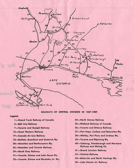
A map detailing the railways during 1847-1889 in Central Ontario. The legend assigns a number to the name of each railway. Composed and published by William Michaud of Shannonville, Ontario.
A map featuring properties and boundaries in the City of Belleville. With area extending from Bay of Quinte to 401 and from N. Front Street to just past Haig Road. Published by the Quinte Planning Board. Scale 1" : 400'.
Schedule plans A - F for the City of Belleville. Researched by the Quinte Planning Board. Published by Totten Sims Hubick; Associates Limited. All maps must be read in conjunction with the associative text provided. 1) M440-1344. Dated Jul 1988. Schedule A - Planning Districts and Planning Units. Scale 0-1000:4". 2) M440-1345. Dated Aug 1974. Revised Jan and Oct 1975. Schedule B - Land Use Plan. Scale 1" : 800ft. 3) M440-1346. Dated Aug 1974. Revised Jan and Oct 1975. Schedule C - Recreation Plan. Scale 1: 9600. 4) M440-1347. Dated Aug 1974. Revised Jan and Oct 1975. Schedule D - Residential Density Plan. Scale 1: 9600. 5) M440-1348. Dated Aug 1974. Revised Jan and Oct 1975 and Sep 1986. Schedule E - Transportation Plan. Scale 1: 9600. 6) M440-1349. Dated 1990. Schedule F - Municipal Services Plan. Scale 1: 9600.
Key to Zoning By-law Maps of the City of Belleville. Scale: 1:4800. Published by the Quinte Planning Board. 1) M440-1328. Dated 6 Nov 1976. Revised 2 Apr 1991. 2) M440-1329. Dated 6 Nov 1976. Revised 6 Jun 1991. 3) M440-1330. Dated 6 Nov 1976. Revised 19 Aug 1991. 4) M440-1331. Dated 6 Nov 1976. Revised 28 May 1991. 5) M440-1332. Dated 10 Oct 1990. 6) M440-1333. Dated 16 Dec 1985. Revised 21 Feb 1990. 7) M440-1334. Dated 19 Dec 1985. Revised
A reproduction of a pre-1949 aerial view photo located in a tourism advertisement book. The booklet advertises Quinte's cruising waters extending from Trenton to Adolphus Reach.
Plan of Vair's Block registered in the Hastings County Land Registry Office, showing Lots # 22 & 23 North side of Bridge Street & Lot # 15 West side of Town Line Street in Belleville, Ontario. The plan was drawn up John James Haslett, Provincial Land Surveyor, in November 1869.
A circa 1940 "Clearview" city directory map of Belleville, Ontario. The map features streets, water ways and major city buildings, as seen in the legend. Surveyed by Charles A. Mott, City Engineer. Published by Vernon Directories (Hamilton, Ontario). Heading of the map "Central Ontario Credit Exchange, The home of Collections, East Robertson Block, 219 Front Street, Licenced and Bonded Collection Specialists."
A map of the City of Belleville, Ontario. The developed streets are pictured alongside their names. Local water ways including the Bay of Quinte and the Moira River are also present. Circa 1950.
Dated after the city limit expansion of 1959 but before the expansion in 1998. Circa 1970.
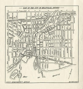
A map of the City of Belleville, Ontario. The developed streets are pictured alongside their names. Local water ways including the Bay of Quinte and the Moira River are also present. Composed by Charles A. Mott and published by the City Engineers Office. Circa 1950.
Dated after the city limit expansion of 1948 but before the expansion in 1959.
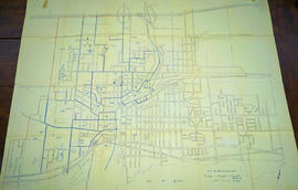
A map showing, primarily, zoning limits within the City of Belleville. The limits are coloured in crayon and can be referenced on the legend (left). The map was first created c. 1959 (as written in pencil). However, more recent revisions were made June 4, 1970. Scale: 1:12,000. Additional information about by-laws is available on the map's border.
Note the two names listed on the top left corner: K. Murray and D. Williams - possible authors or owners.
A map of Hastings County in 1967, including; Hastings Highlands, Trenton and Belleville. Surveyed by D. John Emerson. Published by Canada Map Services.
A map of the City of Belleville, Ontario in November 1963. The developed streets are pictured. Local water ways including the Bay of Quinte and the Moira River are also present.
A map of the City of Belleville (with Trenton inset) featured in the September 20, 1961 issue of the Ontario Intelligencer. The map features houses that were open that week for viewing. At the bottom are sponsors of the map.
A map of the City of Belleville in 1950, on an advertisement for Acme Plumbing. The map itself features street names and major water ways. Street names are at the bottom of the map. Published by S. A. Renouf Advertising Co. and drawn by F. P. Lloyd. Scale 2" : 2,000 feet.
Each map was published by the Ontario Mapping Company and features advertisements, streets, transit routes and points of interest.
1) M440-1367. Dated from 2000-2001. Scale 2.5 cm : 0.5 km. Composed by the Belleville & District Chamber of Commerce. 2) M440-1390. Dated from 2008-2009. 3) M440-1391. Dated from 2006-2007. 4) M440-1392. Dated from 2003-2004. 5) M440-1826. Dated 2010.