
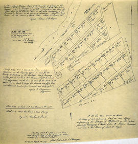
Tyendinaga - Mill Point Incorporation - 1871

Diagram of the proposed outlines for incorporation as the Village of Mill Point

Certification and Plan of Lot 32 in Belleville

Blueprint of CNR Right of Way in Belleville
Survey Plan for Meyers Family Property

Soil Map of Hastings County

Map of the principal settlements of Upper Canada (Part 2)

Map of the principal settlements of Upper Canada (Part 1)
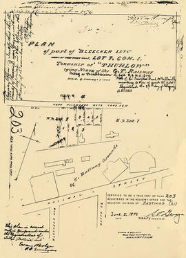
Plan of Bleecker Estate in the Township of Thurlow

Map of Canada indicating Natural Resources

Map of the Dominion of Canada

A New Map of Upper & Lower Canada

Map of Sidney and Thurlow Townships

Plan Z of the Town of Deseronto, Ontario

Plan of Subdivision of Lot 5 in Canniff's Mills

Wallbridge Lease of Indian Lands in Tyendinaga

Survey of the First Loyalists Settlement

Reproduction of a plan of the organized part of the Provinces of Upper Canada

Map of the Belleville Main Arteries

Weller's and Hay Bay Islands claimed by Alnwick Indians
Results 101 to 120 of 883