A map showing the 37 polling subdivisions of Belleville, Hastings County, Ontario. Composed by Charles Mott from the City in August 1958 and published in The Ontario Intelligencer on 28 November 1958.
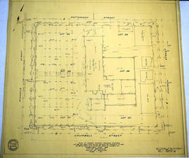
A "Plan of Survey showing Physical Features" detailing city lots, buildings and streets in Belleville. Ontario. By John T. Ransom, Ontario Land Surveyor on January 8, 1959 and revised on March 23, 1959. Scale: 1 inch to 20 feet.
Text: [based on the] Government Plan 1816; [including] Lots # 28 and part of Lots # 27 and 29 East of Pinnacle Street and Lot # 28 and part of Lots # 27 and 29 West of Church Street.
Donated by Tom Ransom, Belleville, surveyor and son of the author.
A map of the City of Belleville in Hastings County, Ontario. Composed and published by Pathfinder Air Surveys Ltd., in 1963. Insets include: 1) Street index 2) Industries index 3) Businesses and services index 4) Legend 5) List of cities with Pathfinder map suppliers 6) Survey information
A copy of a map detailing the temporal and spatial sequence of Belleville's growth from a village to a town and then a city. The different stages of growth (see legend) and administrative boundaries are outlined. Created by the Belleville and Suburban Planning Board in July 1967.
An aerial photograph of Belleville and Sidney Township by P. Sidey (photogrammetric production officer) and H. S. Wilde (chief surveyor). Published by Ontario Hydro, transmission systems division. Scale: 1:10,000.
Plan of the village of St. Albans on lot letter-A, at the Second Concession of Sidney Township in Hastings County, Ontario. Published by Maclear and Co. Lith. in September 1854. Surveyed by J. S. Peterson, Provincial Land Surveyor.
A map of the Ketcheson Ward in Belleville, Ontario. Streets and lots are outlined and named, as well as the River Moira. Scale: 1" = 1 chain. Circa 1870.
A pre-1900 map of the Sampson Ward in Belleville, Ontario. Streets and lots are outlined and named, as well as the Bay of Quinte. Scale: 1" = 3 chains.
A Map of the City of Belleville, Ontario. The developed streets are pictured alongside their names. Local water ways including the Bay of Quinte and the Moira River are also present. Composed by Charles A. Mott and published by the City Engineers Office. Circa 1950.
A map of a town plot at the mouth of the Trent River in the Newcastle District. The map features numbered lots, present streets and water ways. Scale: 1 inch = 2 chains. Originally surveyed by F. P. Rubidge, D.P.S., in 1834. This copy was issued September 23, 1926.
A topographical map of Trenton - Canada sheet 31 C/4. Map was published by the Department of National Defence in December 1962. This second edition was converted from the first edition of the 1:63,360 map to 1:50,000 by the A. S. E. in 1950.
Insets include: 1) legend 2) index to adjoining sheets 3) mean declination 4) grid reference on the sheet and other minor information.
A topographical map of Bancroft - Canada sheet #31 F/4, west half. Published by the Army Survey Establishment, Department of National Defence in 1956. Scale 1:50,000.
A topographical map of Belleville - Canada sheet #31 C/3, west half. Published by the Army Survey Establishment, Department of National Defence in 1956. Scale 1:50,000.
A topographical map of Belleville - Canada sheet #31 C/3, east half. Published by the Army Survey Establishment, Department of National Defence in 1956. Scale 1:50,000.
A topographical map of Campbellford - Canada sheet #31 C/5. Published by the Army Survey Establishment, Department of National Defence in 1956. Scale 1:50,000.
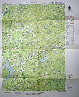
A topographical map of Coe Hill- Canada sheet #31 C/13, west half. Published by the Army Survey Establishment, Department of National Defence in 1956. Scale 1:50,000.
A topographical map of Denbigh - Canada sheet #31 F/3, east half. Published by the Army Survey Establishment, Department of National Defence in 1951. Scale 1:50,000.
A topographical map of Denbigh - Canada sheet #31 F/3. Published by the Army Survey Establishment, Department of National Defence in 1948. Scale 1:50,000.
A topographical map of Kaladar - Canada sheet #31 C/11, east half. Published by the Army Survey Establishment, Department of National Defence in 1950. Scale 1:50,000.