Showing 122 results

Archival description
Map collection Trenton
Print preview Hierarchy View:

83 results with digital objects Show results with digital objects

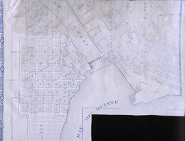
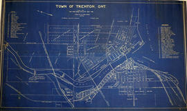
Plans for COR CPR Union Station at Trenton

A blueprint planning the COR and CPR Union Station at Trenton, Hastings County, Ontario. Plan features floor, elevation and sections. Drawn by John Dunlop Evans, Chief Surveyor/Engineer - August 23, 1897.

Evans, John Dunlop, P.L.S.

Map of the Trent Port

Map showing a sketch of the Trent Port - June 12th, 1837. Scale: 2 chains to an inch. Published by the Office of the Surveyor General.

From the Archives of Ontario in Toronto.

Water Communication between the Bay of Quinte and Lake Huron

Map showing a measured sketch of the water communication between the Bay of Quinte and Lake Huron, May 1818. The total area extends from the Bay of Quinte and Lake Huron by Rice Lake to the falls of the River Trent to its mouth. A reproduction from the Archives of Canada.

Map of Lot L on the Trent River

A photostat of a map by from an H. Belden & Company's atlas showing Lot L on the Trent River - 1878.
Donated by K.G.M. Ross in 1963.

H. Belden & Company

Map of the Town of Trenton 1926

A map of the town of Trenton, Ontario in June 1926. The map features numbered lots, present industries, CNR tracks and other important buildings. Streets and their names, as well as the River Trent are also present. Scale: 1:3000. Composed by Mayor W. A. Fraser and published by his Town Council.

Fraser, William Alexander

Depth chart of Trenton Harbour

A copy of an original map by W. Kingsford (Engineer in charge) showing the depths at various points in the Trenton Harbour on the Bay of Quinte - 1875. Scale: 1 : 9,800.
Photocopied by the Archives of Canada 21 Aug 1979.

Kingsford, William

Diagram of Town plot called Trent Port

A copy of an original map by Deputy Provincial Surveyor F. P. Rubidge showing a diagram of a town plot at the mouth of the Trent River called the "Town of Trent Port." Specifically, the map shows Lot 2 near the 1st Concession bordering Murray Township in the County of Northumberland.
Published in Cobourg on September 25, 1852.
Donated by K.G.M. Ross.

Rubidge, Frederick Preston, D.P.S.

Map of Presqu'ile to Kingston

A copy of an original map by Surveyor General John Collins showing land from Presqu'ile to Kingston in 1785. Scale: 4 miles : 1 inch.
Photocopied by the Archives of Canada 10 Jan 1990.

Collins, John, Hon.

Map of Murray Township showing several lots

A copy of an original map by Surveyor General David W. Smith showing several lots of land in Murray Township in the District of Newcastle. Specifically, the map shows Lots 1-5 near the 1st Concession and River Trent. Published by Henry Smith on July 24, 1799.

Donated by K.G.M. Ross in 1963.

Smith, David William

Map of City of Quinte West 2004

A map of Quinte West, Ontario featuring Frankford, Murray, Sidney and Trenton areas. Dated 2004.

Bay of Quinte Regional Mapping

Map of Quinte West

A map of Quinte West, Ontario featuring streets, waterways and significant buildings - see legend for details.

Bay of Quinte Regional Mapping

City of Belleville map from Intelligencer

A map of the City of Belleville (with Trenton inset) featured in the September 20, 1961 issue of the Ontario Intelligencer. The map features houses that were open that week for viewing. At the bottom are sponsors of the map.

Intelligencer

Map of Belleville to North of Bancroft

A map containing focused maps of: Trenton, Belleville, Prince Edward County, Frankford, Picton, Bancroft, Deseronto, Stirling, Tweed, Marmora and Madoc. Insets refer to roads, streets and highways. Published by Millhouse Maps in 2001.

MIllhouse Maps

Lloyd's Map of Hastings County

A map of Hastings County outlining the twelve townships:
Marmora and Lake, Madoc, Tudor, Grimsthorpe, Elzevir; Rawdon, Huntingdon, Hungerford, Sidney, Thurlow, Tyendinaga. The northern townships are pictured on the right side.
As well as, the lots and concessions. Circa 1922. Scale: 1.5 miles: 1 inch. Published by Lloyd's Maps, Map Publisher.

Lloyd's Map, Map Publisher

Map of Hastings with townships

A map of Hastings County outlining the twelve townships:
Marmora and Lake, Madoc, Tudor, Grimsthorpe, Elzevir; Rawdon, Huntingdon, Hungerford, Sidney, Thurlow, Tyendinaga.
As well as, the lots and concessions. Circa 1916.Scale: 4 miles: 1 inch.

Donated by K.G.M. Ross.

Teacher's Guide to Quinte in 1785

Map showing the Bay of Quinte to Presqu'ile to the eastern tip of Grande Isle (Wolfe Island) used as a teacher's guide to the area in 1785. The 20th century names are in capital letters as per the Legend.

Hastings with Town of Belleville and principal villages

A map of Hastings County including the Town of Belleville and other principal villages:

Trenton, Madoc, Marmora, Tweed, Bridgewater, Stirling, Wicklow, Bangor, Herschel, Monteagle, Carl, Dungannon, Wollaston, Limerick, Cashel, Tudor, Grimsthorpe, Elzevir; Rawdon, Huntingdon, Hungerford, Sidney, Thurlow, Tyendinaga.

Scale: 3 miles =1 inch. Published by John P. Evans, P.L.S. in 1869.

Evans, John Dunlop, P.L.S.

Results 101 to 120 of 122