Showing 1302 results

Archival description
Print preview Hierarchy View:

900 results with digital objects Show results with digital objects

Flood Risk Maps of the Lower Trent Region

7 flood risk maps for the Lower Trent Region. Part of the Canada-Ontario Flood Damage Reduction Program.

Ontario. Ministry of Natural Resources and Forestry

Minerals of Ontario

A double sided, folded map showing the location and types of mineral in Ontario. The back side shows photographs of each type of mineral. Published by the Ministry of Industry & Tourism and Ministry of Natural Resources.

Ontario. Ministry of Natural Resources and Forestry

See Ontario By Air

"See Ontario By Air" - a double sided, folded map showing the location and amenities surrounding airports in southern and northern Ontario.

Ontario. Ministry of Transportation

Map of Ontario Geology and Principal Minerals

A double-sided map of Ontario Geology and Principal Minerals. The inside discusses information, research and statistics of minerals found in Ontario. The map shows where the minerals are found in Ontario. Published by the Ontario Dept. of Mines and Northern Affairs in 1970.

Ontario. Department of Mines

Road Map of the Province of Ontario 1967

A road map of the northern and southern portions of the Province of Ontario. Published by the Ontario Department of Highways in 1967 for the Centennial Year. Various indexes and legends are located on the map.

Ontario. Department of Highways

Road Map of the Province of Ontario 1956

A road map of the northern and southern portions of the Province of Ontario. Published by the Ontario Department of Highways in 1956. Various indexes and legends are located on the map.

Ontario. Department of Highways

Road Map of the Province of Ontario 1953

A road map of the northern and southern portions of the Province of Ontario. Published by the Ontario Department of Highways in 1953. Various indexes and legends are located on the map.

Ontario. Department of Highways

Reproduction Map of Principal Communications in Canada West

A reproduction made in 1971 of the Hastings and Prince Edward sections of a Map of the Principal Communications in Canada West by Major Baron de Rottenburg. Original map made in 1850 and held at Library and Archives Canada. Scale 2 miles to an inch. Each of the sheets provides a close look at the roads, lands and lighthouses in the townships and districts at the time. Library and Archives Canada reference: http://central.bac-lac.gc.ca/.redirect?app=fonandcol&id=4138509&lang=eng

DeRottenburg, Major Baron

Map by the Bancroft Mineral Society

A map of the highways, gravel roads, towns and mineral deposits located in the town of Bancroft and the surrounding area. Published by the Bancroft and District Chamber of Commerce. On the reverse side is the key to the numbered mineral deposits - types of minerals and the exact location/owner.

Bancroft and District Chamber of Commerce

Hydrographic map of the Bay of Quinte from Picton to Presqu'ile Bay

  • CA ON00156 2020-075
  • Item
  • 1974

A hydrographic map of the area surrounding the Bay of Quinte, Picton to Presqu'ile Bay in Ontario, Canada. With maps of Trenton Approaches, and Telegraph Narrows inset. Published by the Canadian Hydrographic Service, Marine Sciences Directorate, Department of the Environment, Ottawa. Sheet number 2069.

Scale: 1:60,588

Canadian Hydrographic Service

Topographical maps and Callaghan family scrapbook

  • CA ON00156 2020-011
  • Collection
  • 1970-1994

Collection of Canada Department of Mines and Technical Surveys maps of the Quinte region (1:25,000):
1) Topographical map 30N/15f of False Duck Islands (Prince Edward County), 1965
2) Topographical map 30N/14a of Gull Bar (Prince Edward County), 1965
3) Topographical map 31C/3d of Ameliasburgh (Prince Edward County), 1966
4) Topographical map 30N/15g,h of Main Duck Island (Prince Edward County), 1966
5) Topographical map 30N/14b of Point Petre (Prince Edward County), 1966
6) Topographical map 31C/3a of Glenora (Prince Edward County), 1966
7) Topographical map 31C/4g of Wooler, 1970
8) Topographical map 31C/3e of west Belleville, 1971
9) Topographical map 31C/3f of east Belleville, 1971
10) Topographical map 31C/3h of Deseronto, 1971
11) Topographical map 31C/2e of Napanee, 1971

12) Canadian Hydrographic Service nautical chart (1:30,000), of Belleville to Telegraph Narrows, with Belleville harbour inset, 1982

13) Scrapbook of newspaper clippings relating to members of the Callaghan and Kellaway family, including Chris Simboli, Thomas Callaghan, Kay Callaghan, Don Kellaway, Ellen Kellaway, Frank Maloney, Michael Callaghan, Theresa Kellaway and Jack Bradford, 1983-1994

Kellaway, Don

Road Map of Hastings County 1953

A road map of Hastings County in 1953. Portions of adjoining counties are also pictured. Boundaries are yellow, while roads are blue and red. Published by the Ontario Department of Highways. Scale: 1 inch = 4 miles.

Ontario. Department of Highways

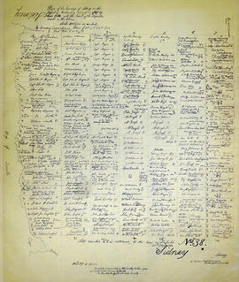
Map of Sidney Township in 1787 - 1981 rewrite

A recopy of the 1787 map of Sidney Township. The original map entitled "Plan of the Township of Sidney in the District of Mecklinburg. Surveyed in 1787 by Lewis Kotts, with the names of the proprietor inserted in the Lots." The recopy was completed by Mrs. Dorothy Ashton in 1981, for the Corby Public Library and Hastings County Historical Society. Scale 40 chains to an inch.

Donated by the Belleville Public Library in 2014.

Kotte, Lewis

Re-subdivision of Lot 8 in the City of Belleville

A certified reproduction of the "Re-subdivision of portions of MacDonald and Maud Plans, now the property of the Burrell Rock Drill Company & others, being part of the west half of Lot # 8, Concession 1, Township of Thurlow.” Surveyed by Henry Carre O. L. S., and signed April 29, 1910.

This copy was made in 1972 of plan #391, as registered in the Hastings Land Registry Office.

Donated by Walter I. Watson, P. L. S.

Carre, Henry, O.L.S.

Topographic Map of Ontario - Belleville Sheet

A map from the Eastern Canada series entitled "Topographic Map of Ontario - Belleville Sheet 31 C/3." The map includes Hastings County to Hillier in Prince Edward County. Published in 1938 by the Department of National Defence. Scale 1 inch to 1 mile.

Donated by the Belleville Public Library in 2014.

Canada. Department of National Defence

Plan of the town of Belleville 1845

Photocopy of a plan of the town of Belleville, 1845. By John J. Haslett, D.D. Surveyor. Scale: 3 chains to 1".

Haslett, John James, P.L.S. & D.P.S.

Plan of block in east end of Belleville

  • CA ON00156 M/M440-1301
  • Item
  • 1 Mar 1951-14 Apr. 1960
  • Part of Map collection

A map showing a plan of survey for lots 4, 5, 6, 7, 8, 9 and lots 37, 38, 39, 40 on the south side of Bridge Street East between Dufferin and Macdonald Avenues in Belleville, Ontario. Surveyed by John T. Ransom on March 1, 1951 and amended April 14, 1960. Scale: 1'':50'.

Ransom, John Thomas, P.L.S.

Map of Hastings County, Ontario

  • CA ON00156 DA 2011.03
  • Item
  • c.1947

Map of Hastings County, Ontario, with business directory information for Belleville, Deseronto, Frankford, Madoc, Shannonville, Stirling and Tweed in the right and left-hand panels.

Croydon Publishing Company

Results 101 to 120 of 1302