Showing 1287 results

Archival description
Map collection
Print preview Hierarchy View:

892 results with digital objects Show results with digital objects

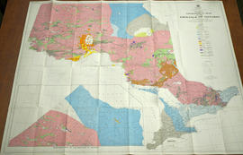
Road Map of Hastings County 1953

A road map of Hastings County in 1953. Portions of adjoining counties are also pictured. Boundaries are yellow, while roads are blue and red. Published by the Ontario Department of Highways. Scale: 1 inch = 4 miles.

Ontario. Department of Highways

Map of Sidney Township in 1787 - 1981 rewrite

A recopy of the 1787 map of Sidney Township. The original map entitled "Plan of the Township of Sidney in the District of Mecklinburg. Surveyed in 1787 by Lewis Kotts, with the names of the proprietor inserted in the Lots." The recopy was completed by Mrs. Dorothy Ashton in 1981, for the Corby Public Library and Hastings County Historical Society. Scale 40 chains to an inch.

Donated by the Belleville Public Library in 2014.

Kotte, Lewis

Re-subdivision of Lot 8 in the City of Belleville

A certified reproduction of the "Re-subdivision of portions of MacDonald and Maud Plans, now the property of the Burrell Rock Drill Company & others, being part of the west half of Lot # 8, Concession 1, Township of Thurlow.” Surveyed by Henry Carre O. L. S., and signed April 29, 1910.

This copy was made in 1972 of plan #391, as registered in the Hastings Land Registry Office.

Donated by Walter I. Watson, P. L. S.

Carre, Henry, O.L.S.

Topographic Map of Ontario - Belleville Sheet

A map from the Eastern Canada series entitled "Topographic Map of Ontario - Belleville Sheet 31 C/3." The map includes Hastings County to Hillier in Prince Edward County. Published in 1938 by the Department of National Defence. Scale 1 inch to 1 mile.

Donated by the Belleville Public Library in 2014.

Canada. Department of National Defence

Plan of the town of Belleville 1845

Photocopy of a plan of the town of Belleville, 1845. By John J. Haslett, D.D. Surveyor. Scale: 3 chains to 1".

Haslett, John James, P.L.S. & D.P.S.

Plan of block in east end of Belleville

  • CA ON00156 M/M440-1301
  • Item
  • 1 Mar 1951-14 Apr. 1960
  • Part of Map collection

A map showing a plan of survey for lots 4, 5, 6, 7, 8, 9 and lots 37, 38, 39, 40 on the south side of Bridge Street East between Dufferin and Macdonald Avenues in Belleville, Ontario. Surveyed by John T. Ransom on March 1, 1951 and amended April 14, 1960. Scale: 1'':50'.

Ransom, John Thomas, P.L.S.

Map of planned Belleville Harbour

A map showing a plan for the Belleville Harbour. The total area stretches from south Front Street to the Ponton Plan. Published by John T. Ransom on May 19th, 1947. The map features field notes of survey of lands, marshes and Bay of Quinte waters. Scale: 1':100'.

Ransom, John Thomas, P.L.S.

Map of Mineral Deposits in Coehill and Jenkins

"Coehill and Jenkins Irone Ore Deposits, Lots 15, 16, 17, 18, Concession 8, Township of Wollaston, Hastings County, Ontario."

A map published by the Department of Mines of Canada, in 1911, showing contour lines, magnetic intensities and other physical features. Surveyed by E. Lindeman.

Donated by Nick January in 2016.

Canada. Department of Mines and Technical Surveys

Geological Map of the Province of Ontario

A Geological Map of the Province of Ontario published by the Ontario Department of Mines in 1958. Geology compiled by J. Satterly from published and unpublished maps of the Ontario Department of Mines, the Geological Survey of Canada, mining companies & technical publications (as per Legend). Scale 1 inch to 20 miles.

Ontario. Department of Mines

Map of the Canadian National Railway System

A map of the Canadian National Railway System published in 1965. The system composed of; the Central Vermont Railway Inc., the Grand Trunk Western Railroad Co., Duluth, Winnipeg and Pacific Railways Company. Also featuring sponsored hotels, lines under construction and offline traffic offices. The total system mileage is 25,000.

Canadian National Railways

Certification and Plan of Lot 32 in Belleville

A lot certification and map of Lot 32, at the intersection of Front and Bridge Streets, in the town of Belleville. Certified by P.L.S. David Williams and signed April 13, 1870.

Williams, David, P.L.S.

Plan Showing A Development at Belleville, Ontario

"Plan Showing a Development at Belleville, Ontario, Canada." Includes the proposal of 3 urban areas labelled A, B, & C, and the proposed building of an international airport and casino. Drawn at the City Engineer's Office and signed February 1925.

Mott, Charles Allan

Blueprint of CNR Right of Way in Belleville

A blueprint plan showing land required by the Canadian Northern Ontario Railway for a proposed right-of-way on Lots 1-2A, Dundas Street, Belleville. The property belonging to Mary E. Ponton is coloured in pink and amounts to 1.05 acres. The plan was signed on October 23, 1911 at Toronto.

Stewart, A. F.

Plan of Belleville Rifle Range

An original oilcloth plan of the "Belleville Rifle Range." The range was located on the waterfront of the Bay of Quinte and from Foster Avenue eastward. Surveyed by Henry Carre, C.E. & O.L.S. and signed at Belleville on June 2, 1896.

The plan received stamps from 3 offices; Henry Carre (Provincial L. Surveyor in Belleville), the Adujtant General's Office of Canada (June 5, 1896), and the Minister of Militia and Defence. Also featured on the plan are distances from the target (in red), streets, Lingham's Wharf, two Islands and a Marsh.

Donated by Col. W. N. Ponton Estate.

Carre, Henry, O.L.S.

Survey Plan for Meyers Family Property

A survey plan (registered plan number 126) by Michael Teal, of the Meyers family property in the village of Belleville, Thurlow Township. Specifically, on the north half of Lot 5, 1st concession. The Moira River East and Taylor's lot borders the Meyers' property. Dated May 20, 1829. Scale 2 chains to an inch.

See the 6 note sets from different registrars on the map.

Teal, Michael

Soil Map of Hastings County

A Soil Map of Hastings County Ontario, South Sheet, Soil Survey Report # 27. Published by the Experimental Farms Service of Ottawa. in 1958. Base maps supplied by the Department of Mines and Technical Surveys. Soil survey by the Department of Soils, Ontario Agricultural College, Guelph and the Experimental Farms Service, Canada Department of Agriculture, Ottawa. Scale 1 inch to 1 mile.

Canada. Department of Agriculture

Geography of the Heavens - a Celestial Atlas

A "Celestial Atlas designed to illustrate the Geography of the Heavens" by Elijah Hinsdale Burritt, an American astronomer and mathematician. This second edition was published in 1833 by F. J. Huntingdon in the Clerk's Office of the District Court of Connecticut. The pages are as follows:

  1. "The visible heavens in October, November and December."
  2. "The visible heavens in January, February and March."
  3. "The visible heavens in April, May and June."
  4. "The visible heavens in July, August and September."
  5. "The visible heavens in the North polar region for each month of the year."
  6. "The visible heavens in the South polar region for each month of the year."
  7. "Planisphere of the whole heavens on Mercator's projection."

Burritt, Elijah Hinsdale

Map of Lower Canada, Quebec and Ontario

A reproduction of part of a map showing Lower Canada, Quebec and Ontario in 1825. Map shows bodies of water and names of settlements. The boundary of Lower Canada is according to a treaty with the United States. From the Archives of Canada on July 27, 1966. Donated by Chewett.

Results 101 to 120 of 1287