Showing 895 results

Archival description
Map collection Image
Print preview Hierarchy View:

895 results with digital objects Show results with digital objects

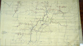
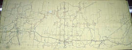
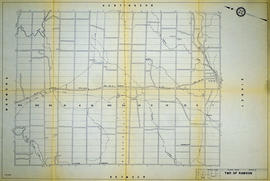
Hydro-Electric Power Commission of Ontario, Rawdon Section

  • CA ON00156 M/M430-2995 - 2996, 3018 - 3021, 3031/2995
  • Item
  • 16 Dec 1964
  • Part of Map collection

A reproduction of an original map produced for the Hydro-Electric Power Commission of Ontario, concerning the boundaries of their eastern region in the Township of Rawdon. However, the map also features railways, roads and land boundaries. Dated December 16, 1964. Scale: 2 inches = 1 mile.

Donated by David Pershick.

Hydro-Electric Power Commission of Ontario, Tweed Section

  • CA ON00156 M/M430-2995 - 2996, 3018 - 3021, 3031/3021
  • Item
  • 16 Oct 1951
  • Part of Map collection

An original map produced for the Hydro-Electric Power Commission of Ontario, concerning hydro power lines, stations and transformers. However, the map also features railways, roads and land boundaries.

This map is of the Southwest Section - Tweed Rural Power District. The total area includes parts of Hungerford, Huntingdon, and Thurlow Townships. Dated October 16, 1951. Scale: 2 inches = 1 mile.

Donated by David Pershik.

Hydro-Electric Power Commission of Ontario, Tweed-Section

  • CA ON00156 M/M430-2995 - 2996, 3018 - 3021, 3031/3018
  • Item
  • 16 Oct 1951
  • Part of Map collection

An original map produced for the Hydro-Electric Power Commission of Ontario, concerning hydro power lines, stations and transformers. However, the map also features railways, roads and land boundaries.

This map is the West Centre Section - Tweed ROA. The total area includes parts of Rawdon, Marmora, Huntingdon, Madoc, Hungerford, and Elzevir Townships. Dated October 16, 1951. Scale: 1.2 inches = 1 m.

Donated by David Pershik.

Hydrographic Map of Bay of Quinte, Picton to Presqu'ile Bay

A hydrographic map of the area surrounding the Bay of Quinte, Picton to Presqu'ile Bay in Ontario, Canada. With maps of Trenton Approaches, [racist slur redacted] Narrows, Belleville Harbour & Telegraph Narrows inset. Surveys completed in in 1952-53 and 1957. Map printed June 15, 1962. Published by the Canadian Hydrographic Service, Marine Sciences Branch, Department of Mines and Technical Surveys, Ottawa. Sheet number 2069.

Canadian Hydrographic Service

Hydrographic Map of Belleville Bridge to Telegraph Narrows

A hydrographic map of Belleville Bridge to Telegraph Narrows (Bay of Quinte) in Ontario, Canada. Surveys completed in 1893, 1953, 1957. Map printed July 30, 1959. Published by the Canadian Hydrographic Service, Surveys and Mapping Branch, Department of Mines and Technical Surveys, Ottawa.

Donated by the Glanmore National Historic Site in 2016.

Canadian Hydrographic Service

Hydrographic Map of Deseronto to Presqu'ile

A hydrographic map of Deseronto to Presqu'ile (Bay of Quinte) in Ontario, Canada. Surveys completed in 1893. Map printed June 1940. Published by the Hydrographic and Map Service, Surveys and Engineering Branch, Department of Mines and Resources, Ottawa.

Donated by the Glanmore National Historic Site in 2016.

Canadian Hydrographic Service

Hydrographic Map of Plans in Bay of Quinte

A hydrographic map of Plans in the Bay of Quinte, Ontario, Canada. 4 inset maps are included of the 1) Trenton and Approaches, 2) Belleville, 3) [Racist slur redacted] Narrows, and 4) Telegraph Narrows. Nautical surveys completed by Col. W. P. Anderson in 1893 and Mr. E. A. Ghysens in 1934. Map printed March 25, 1952. Published by the Canadian Hydrographic Service, Department of Mines and Technical Surveys, Ottawa.

Canadian Hydrographic Service

Hydrographic Map of Upper Gap to Telegraph Narrows

A hydrographic map of Upper Gap to Telegraph Narrows (Bay of Quinte and Lake Ontario) in Ontario, Canada. Surveys completed in in 1917 and 1952-53. Map printed April 28, 1955. Published by the Canadian Hydrographic Service, Surveys and Mapping Branch, Department of Mines and Technical Surveys, Ottawa.

Donated by the Glanmore National Historic Site in 2016.

Canadian Hydrographic Service

Information Guide Map of Belleville

An information guide map of Belleville for visitors to the area. Map features points of interest within the southern part of the city. Circa 1961.

Belleville Chamber of Commerce

Kaladar Township Map # 446771W

  • CA ON00156 M/M470-2591 - 2616/2612
  • Item
  • c. 1950
  • Part of Map collection

A reproduction of an air survey photograph produced by the Ontario Ministry of Natural Resources. Map #446771W of Kaladar Township in Lennox and Addington County, Ontario. Circa 1950.

The photograph shows Kaladar Township, Concession 1 to 7, Hwy 41, Northbrook and west to Flinton, the Skootamata River and the border of Anglesea Township.

Donated by Walter I. Watson, P.L.S.

Ontario. Ministry of Natural Resources and Forestry

Kennebec Township Map # 446771E

  • CA ON00156 M/M470-2591 - 2616/2611
  • Item
  • c. 1950
  • Part of Map collection

A reproduction of an air survey photograph produced by the Ontario Ministry of Natural Resources. Map #446771E of Kennebec Township in Frontenac County, Ontario. Circa 1950.

The photograph shows Kennebec Township, Concession 1 to 5 and south to Cranberry Lake.

Donated by Walter I. Watson, P.L.S.

Ontario. Ministry of Natural Resources and Forestry

Lake Township Map # 446773W

  • CA ON00156 M/M470-2591 - 2616/2616
  • Item
  • c. 1950
  • Part of Map collection

A reproduction of an air survey photograph produced by the Ontario Ministry of Natural Resources. Map #446773W of Lake Township in Hastings County, Ontario. Circa 1950.

The photograph shows Concession 6 to 9 from the border with Marmora Township, north to Little Burnt Lake and Big Burnt Lake and Carson Lake.

Donated by Walter I. Watson, P.L.S.

Ontario. Ministry of Natural Resources and Forestry

Land Settlement Map of the Moira Valley

A map of the land settlement, including roads and mills, located in the Moira Valley. This information has been superimposed on Publius V. Elmore's 1836 map of the Midland District.

The mills featured: Bleecker's Saw Mill, Mire's Grist Mill, Saw and Grist Mil, Colman's Mill, Jonas Canniff's Saw Mill, Joseph Canniff's Saw & Grist Mills, Daniel Canniff's Saw & Grist Mills, Reed's Saw Mill, Eowerman's Saw Mill, Thorn's Saw Mill, Thomson's Mill, Latta's Saw & Grist Mill, Carter's Saw Mill, Trumpour's Saw Mill, Munro's Saw & Grist Mill, McKenzie's Saw and Grist Mill, and Reed's Grist Mill.

Intelligencer

Land Use Plan for the City of Belleville

A map of the City of Belleville showing planned usage of the land - see legend for the different uses. Composed by Charles A. Mott and published by the City Engineers Office. Dated January 1949. Scale 1:8000.

Donated by K. G. M. Ross.

Mott, Charles Allan

Land Use Survey of the Moira Watershed

"Moira Watershed Land Use Survey [for] Recommended Land Use." The varieties of land use include unrestricted, conservation farming, restricted use, permanent vegetation and woodland. Published by the Ontario Department of Planning Development, Conservation Branch in 1950.

Ontario. Department of Planning and Development

Layout of Buildings at County Court House

A General Layout of the Buildings at the Hastings County Court House on Pinnacle Street in Belleville, Ontario. All buildings are named. Composed by Charles D. Campbell, O.L.S, and dated October 16, 1927.

Donated by Heritage Belleville in 2017.

Campbell, Charles Donald, O.L.S.

Leisure Acres Subdivision in the Township of Thurlow

A certified reproduction of the "Leisure Acres Subdivision of part of Lot # 1, Concession III, Thurlow, owner Clarence S. Bird.” The area includes; east of road allowance between Townships of Sidney & Thurlow with Lots on Thurlow Drive, Bird Crescent and Leisure Drive. Surveyed by Ronald Benn, O. L. S. and signed March 26, 1963.

Donated by Walter I. Watson, P. L. S.

Benn, Ronald, O.L.S.

Lloyd's Map of Hastings County

A map of Hastings County outlining the twelve townships:
Marmora and Lake, Madoc, Tudor, Grimsthorpe, Elzevir; Rawdon, Huntingdon, Hungerford, Sidney, Thurlow, Tyendinaga. The northern townships are pictured on the right side.
As well as, the lots and concessions. Circa 1922. Scale: 1.5 miles: 1 inch. Published by Lloyd's Maps, Map Publisher.

Lloyd's Map, Map Publisher

Lot Division Map of Sidney Township

A lot division map of Sidney Township in Hastings County, Ontario. Published by the Department of Land Surveys on August 18th, 1944. Scale: 1=4,000.

Bottom right corner reads "Dominion of Canada, War Assets Corporation" and discusses a storage yard location on Lot 3, Concession 1.

Department of Land Surveys

Results 101 to 120 of 895