
- CA ON00156 TR/1352-1/2
- Item
- 1958
Newspaper article on the Manor house in Belleville. Includes photograph.
174 results with digital objects Show results with digital objects
Newspaper article on the Manor house in Belleville. Includes photograph.

Part of Map collection
A pre-1900 map of the Baldwin Ward in Hastings County. Streets and lots are outlined and named, as well as the River Moira. Scale: 1" = 3 chains.
Written in ink on cotton.
Map of Belleville - The Friendly City
Part of Map collection
A map of the Belleville featuring details about its history. Published by City Print International in 1991.
Campbell, Neil

Map of Belleville's Growth from 1816-1965
Part of Map collection
A copy of a map detailing the temporal and spatial sequence of Belleville's growth from a village to a town and then a city. The different stages of growth (see legend) and administrative boundaries are outlined. Created by the Belleville and Suburban Planning Board in July 1967.
Belleville and Suburban Planning Board

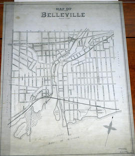
Map of City Streets in Belleville 1919
Part of Map collection
An original map showing the streets and businesses of the City of Belleville, in 1919. By John G. Mill, City Engineer. Scale: 1" : 400 feet.
Mill, John G.
Map of City Streets in Belleville 1932
Part of Map collection
An original map showing the streets of the City of Belleville, as of January 6, 1932. By Charles A. Mott, City Engineer. Scale: 1" : 400 feet.
Mott, Charles Allan

Map of City Streets in Belleville 1940
Part of Map collection
An original map showing the streets of the City of Belleville, in March 1940. By Charles A. Mott, City Engineer. Scale: 1" : 400 feet.
Mott, Charles Allan
Part of Map collection
A planning map of the Coleman Ward, Part ll in Belleville. Streets and lots are outlined and named, as well as the River Moira. Scale: 1" = 3 chains.
Written in ink on cotton.

Map of Deseronto city lots and ownership
Part of Map collection
A map of lots and their owners in the town of Deseronto in Hastings County, Ontario. Black lines show claims to holdings in 1890 and red lines show lots as staked. Scale 1:12,000. Dated 1890.

Map of Hastings and Prince Edward Counties
Part of Map collection
A map showing the roads, forts and inns of Hastings and Prince Edward Counties in 1850, by Major Baron DeRottenburg. The map extends from Brighton to Gananoque, Prince Edward County. and North to include Rawdon, Huntingdon, Hungerford Townships of Hastings County. Scale: 2 miles = 1". Dimensions 63cm x 44cm.
DeRottenburg, Major Baron

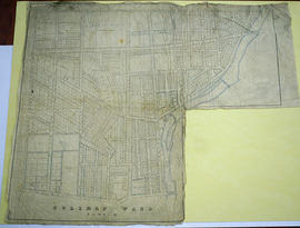
Part of Map collection
A map of the Ketcheson Ward in Belleville, Ontario. Streets and lots are outlined and named, as well as the River Moira. Scale: 1" = 1 chain. Circa 1870.
Written in ink on cotton.

Map of Park and Building Lots Plan in Thurlow
Part of Map collection
An original map showing a plan for park and building lots on Bleecker Avenue between Concession 2 (College Street) and Bridge Street in Thurlow Township, Ontario. Along with the creation of subdivisions, Meyers Street was also being planned. Drawn by Philip Short for P. V. Elmore, P.L.S. Created on February 9, 1863 and registered 18 days later on February 27. Scale 3.5 chains to an inch.
Property of Tobias Blecker.
Short, Philip

Part of Map collection
A pre-1900 map of the Sampson Ward in Belleville, Ontario. Streets and lots are outlined and named, as well as the Bay of Quinte. Scale: 1" = 3 chains.
Written in ink on cotton. From the Ponton Estate.
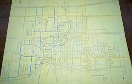
Map of the Belleville Central Business District
Part of Map collection
A map of the Belleville Central Business District in Belleville from Church Street west to Moira River and from CPR north to Station Street.
Quinte Planning Board
Map of the City of Belleville 1963
Part of Map collection
A map of the City of Belleville, Ontario in November 1963. The developed streets are pictured. Local water ways including the Bay of Quinte and the Moira River are also present.

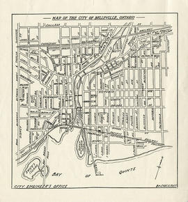
Map of the City of Belleville, Ontario
Part of Map collection
A Map of the City of Belleville, Ontario. The developed streets are pictured alongside their names. Local water ways including the Bay of Quinte and the Moira River are also present. Composed by Charles A. Mott and published by the City Engineers Office. Circa 1950.
Mott, Charles Allan
Map of the City of Belleville, Ontario
Part of Map collection
A map of the City of Belleville, Ontario. The developed streets are pictured alongside their names. Local water ways including the Bay of Quinte and the Moira River are also present. Composed by Charles A. Mott and published by the City Engineers Office. Circa 1950.
Dated after the city limit expansion of 1948 but before the expansion in 1959.
Mott, Charles Allan
Map of the City of Belleville, Ontario c. 1970
Part of Map collection
A map of the City of Belleville, Ontario. The developed streets are pictured alongside their names. Local water ways including the Bay of Quinte and the Moira River are also present. Circa 1950.
Dated after the city limit expansion of 1959 but before the expansion in 1998. Circa 1970.
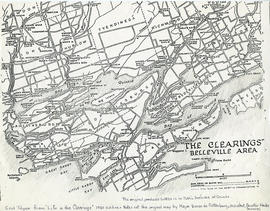
Map of the clearings in Belleville Area
Part of Map collection
A map of clearings in the Belleville Area, 1850. The area of the map stretches from the Belleville Area and Prince Edward County, to Tyendinaga and over to Amherst Island. Published by Baren de Rottenburg, Assistant Quarter Master General C.
This map is featured as the end of "Life in the Clearings" - 1950 edition. It is not a true copy of the original by Major Baron de Rottenburg. The original can be found in the Library and Archives of Canada.
DeRottenburg, Major Baron

Map of the County of Hastings and Adjoining Townships
Part of Map collection
"Map of the County of Hastings and Adjoining Townships. Compiled from Actual Surveys & The Latest Authorities by W. R. Elmore, C.E. Scale 100 chains to an inch. [Published by] Snyder, Black & Sturn, New York."
The townships within Hastings include Lake, Marmora, Madoc, Elzevir, Rawdon, Huntingdon, Hungerford, Sidney, Thurlow and Tyendinaga. The adjoining townships of other counties include Murray, Seymour, Belmont, Kaladar and Richmond. At the the top corners are drawings of the Courthouse and Jail, and the Episcopal Methodist Seminary, both in the town of Belleville.
Featured on the map: settlements, lots, concessions, road allowances, boundaries, mills, schools, post offices, other roads and railroads.
Elmore, William R., C. E.