Print preview Close

Showing 817 results

Archival description
Land, settlement and immigration Image
Print preview Hierarchy View:

817 results with digital objects Show results with digital objects

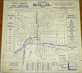
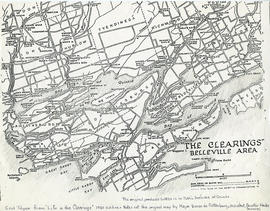
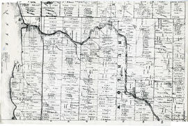
Map of Belleville's Growth from 1816-1965

A copy of a map detailing the temporal and spatial sequence of Belleville's growth from a village to a town and then a city. The different stages of growth (see legend) and administrative boundaries are outlined. Created by the Belleville and Suburban Planning Board in July 1967.

Belleville and Suburban Planning Board

Vernon Mights Clearview Map of Belleville

A 1932 "Clearview" city directory map of Belleville, Ontario. The map features streets, water ways and major city buildings, as seen in the legend. Composed by Charles A. Mott, City Engineer. Published by Vernon Directories (Hamilton, Ontario) and Might Directories (Toronto, Ontario). Six advertisements also border the map.

Donated by Doctor Harold Reid.

Mott, Charles Allan

Maps of the Districts of Upper Canada

4 maps showing the Districts of Upper Canada between 1788-1849:

  1. Province of Upper Canada, original districts of 1788 and districts in 1802 (District boundaries 1788, dotted line, District boundaries 1802, solid line)
  2. Province of Upper Canada, original counties, ca. 1793
  3. Province of Upper Canada, districts in 1836
  4. Province of Canada West, districts in 1849

Map of the clearings in Belleville Area

A map of clearings in the Belleville Area, 1850. The area of the map stretches from the Belleville Area and Prince Edward County, to Tyendinaga and over to Amherst Island. Published by Baren de Rottenburg, Assistant Quarter Master General C.

This map is featured as the end of "Life in the Clearings" - 1950 edition. It is not a true copy of the original by Major Baron de Rottenburg. The original can be found in the Library and Archives of Canada.

DeRottenburg, Major Baron

Thurlow Township Land Division

A plan showing the division of the South half of Lot #8 in the second concession of Thurlow Township, May 10, 1874, property of the University of Toronto. By T.O. Bolger, P.L.S. Scale: 1:2000. Dimensions: 46.0cm x 31.0cm.

Donated by Dorothy Ashton, 1987.

Bolger, Thomas Oliver, P.L.S.

Hastings with Town of Belleville and principal villages

A map of Hastings County including the Town of Belleville and other principal villages:

Trenton, Madoc, Marmora, Tweed, Bridgewater, Stirling, Wicklow, Bangor, Herschel, Monteagle, Carl, Dungannon, Wollaston, Limerick, Cashel, Tudor, Grimsthorpe, Elzevir; Rawdon, Huntingdon, Hungerford, Sidney, Thurlow, Tyendinaga.

Scale: 3 miles =1 inch. Published by John P. Evans, P.L.S. in 1869.

Evans, John Dunlop, P.L.S.

Lot Division Map of Sidney Township

A lot division map of Sidney Township in Hastings County, Ontario. Published by the Department of Land Surveys on August 18th, 1944. Scale: 1=4,000.

Bottom right corner reads "Dominion of Canada, War Assets Corporation" and discusses a storage yard location on Lot 3, Concession 1.

Department of Land Surveys

Map of Expropriated Land for Trenton Air Base

A map of Sidney Township, part of Concession #1 and Broken Front, October 18th, 1912. The map details a tract of land expropriated for Trenton Air Base. Scale: 12.5 chains : 1 inch.

Attached is a letter dated May 1st, 1931, The King versus Maitland Hutton and Leda Hutton.

Sidney Township Plan of Lots

A map of Sidney Township, the Plan of Lots on Gladstone Avenue/Trent Road, 1912. Published by Lucien & Allen C.E. on January 2nd, 1912. Created by A.W. Ponton, P.L.S. Scale: 100 feet : 1 inch.

Ponton, Archibald William, P.L.S. & D.L.S.

Map of Fredericksburg Township

A survey plan map of the Township of Fredericksburg, 1784. Contains names of local property owners and bodies of water. Composed by James Peachy, Lewis Kotte, Henry Holland and Samuel Jaffe. Scale: 40 chains in an inch. Dimensions: 53cm x 39cm.

Peachey, James, D.L.S.

Map of Cashel Township

A map showing concessions and lots of Cashel Township, Hastings County. Circa 1869. 13 advertisements for companies are present on the left-hand side. Published by Macleod and Carre, Engineers and Surveyors. Scale: 1:63,000. Dimensions: 29.0cm x 33cm. Map was created from Government plan.

Donated from the Col. W. N. Ponton Estate. Penciled notes on map show Ponton family's interest in mining, especially after the Eldorado Gold Rush in 1866.

MacLeod and Carre, P.L.S.

Map of Madoc Township

A map showing concessions and lots of Huntingdon - Madoc Township, Hastings County. Circa 1869. 30 advertisements for companies surround the map. Published by Macleod and Carre, Engineers and Surveyors. Scale: 1:63,000. Dimensions: 34.0cm x 37.0cm. Map was created from Government plan.

Donated from the Col. W. N. Ponton Estate. Penciled notes on map show Ponton family's interest in mining, especially after the Eldorado Gold Rush in 1866.

MacLeod and Carre, P.L.S.

Map of Elzevir Township

A map showing concessions and lots of Elzevir Township, Hastings County. Circa 1869. 16 advertisements are present on the left-hand side. Published by Macleod and Carre, Engineers and Surveyors. Scale: 1:63,000. Dimensions: 29.0cm x 37.5cm.

MacLeod and Carre, P.L.S.

Map of Southern Hastings County

Southern Hastings County in 1963. Map features boundaries, roads and railways. Scale: 1:63,360. Published by the Department of Highways, Ontario. Made by Hunting Survey Corp. Ltd. Dimensions 107.5cm x 92.5cm.

A unique "one-inch" map because all one-inch series maps were converted to 1:50,000 after 1950. However, this map was converted to 1:63,360.

Ontario. Department of Highways

Map Hastings, Prince Edward, Northumberland and Peterborough Counties

A map of Hastings, Prince Edward, Northumberland and Peterborough counties in 1916 from the Department of Interior Canada. Published by J.E. Chalifour, Chief Geographer. Scale: 3" to 95 miles. Dimensions 63.5cm x 96.5cm.

The legend includes additional information about counties, towns, villages, boundaries, railways, canals, lots, concessions, portages, rapids and First Nations Territories.

Canada. Department of the Interior

Results 801 to 817 of 817