Showing 109 results

Archival description
Item Geographic features With digital objects
Print preview Hierarchy View:
Murray Township Map # 442773W
New Railway and Commerical Map of Ontario
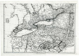
Parts of Ontario and USA in 1834
Plan of Gatling Co.'s Gold Mining Property and adjoining lots in Marmora
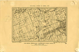
Plan showing Corundum Deposits in Hastings County
Proposed Towns and Military Roads of Upper Canada
Rawdon Township Map # 443772W
Rawdon Township Map # 443773E
Rawdon Township Map # 444773E
Rawdon Township Map # 444773W
Reforestation Land and Existing Woodland in the Moira Watershed
Reproduction of a map of Canada West, formerly Upper Canada
Reproduction of a map of the province of Upper Canada
Reproduction of a map of Upper Canada
Reproduction of map of Province of Canada, western sheet
Richmond Township Map # 443771E
Road Map of Hastings and Prince Edward Counties
Road Map of Hastings County 1953
Road Map of Hastings County 1956
Road Map of Hastings County 1959
Results 61 to 80 of 109