Showing 813 results

Archival description
Item Land, settlement and immigration Image
Print preview Hierarchy View:

813 results with digital objects Show results with digital objects

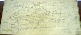
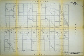
Graphic Index of Lot 28, Belleville

A certified reproduction of the "Registrar's compiled plan, being a graphic index of part of Lot # 28, Concession 1, Township of Sidney now City of Belleville.” The area includes; 14 Lots in Concession 1, west of Sidney Street and south of Moira Street. Surveyed by S. C. Geneja CST, Registry Office of Hastings and signed May 10, 1968.

Donated by Walter I. Watson, P. L. S.

Geneja, Stephen Conrad, CST

Graphic Index of Lot 37, Belleville

A certified reproduction of the "Registrar's Compiled Plan, being a graphic index of part of Lot # 37, Concession 1, Township of Sidney... now City of Belleville.” The area includes; Lots # 1 to 15 Westerly from Sidney Street to Palmer Road and Northerly from Bridge St. West to Moira Street West.. Surveyed by S. C. Geneja CST, Registry Office of Hastings and signed May 28, 1968.

Donated by Walter I. Watson, P. L. S.

Geneja, Stephen Conrad, CST

Graphic Index of Lots 37-38, Belleville

A certified reproduction of the "Registrar's Compiled Plan, being a graphic Index of Part of Lots # 37 and 38, Concession 1, Township of Sidney now City of Belleville.” The area includes;Lots # 1 to 50 Westerly from Sidney Street to Palmer Road and Northerly from Leland Drive to Bridge Street West. Surveyed by S. C. Geneja CST, Registry Office of Hastings and signed July 2, 1968.

Donated by Walter I. Watson, P. L. S.

Geneja, Stephen Conrad, CST

Haslett's 1868 Plan of Belleville

A 1972 copy of a "Plan of the Town of Belleville, as laid out in subdivisions - A.D. 1868." City lots, wards and street names are identified on the map. Surveyed by John J. Haslett, P.L.S.

Haslett, John James, P.L.S. & D.P.S.

Hastings with Town of Belleville and principal villages

A map of Hastings County including the Town of Belleville and other principal villages:

Trenton, Madoc, Marmora, Tweed, Bridgewater, Stirling, Wicklow, Bangor, Herschel, Monteagle, Carl, Dungannon, Wollaston, Limerick, Cashel, Tudor, Grimsthorpe, Elzevir; Rawdon, Huntingdon, Hungerford, Sidney, Thurlow, Tyendinaga.

Scale: 3 miles =1 inch. Published by John P. Evans, P.L.S. in 1869.

Evans, John Dunlop, P.L.S.

Highlands of Hastings, Trenton and Belleville Maps

A map entitled "Highlands of Hastings, Trenton and Belleville," published by the Canada Map Service in honour of Canada's Centennial. Area includes Trenton and Belleville on the front and on the backside west Frankford, east to Hungerford, north to Lake St. Peter and south to the Bay of Quinte. Dated 1966-1967.

Canada Map Service

Hungerford Township Map # 444771W

  • CA ON00156 M/M470-2591 - 2616/2600
  • Item
  • c. 1950
  • Part of Map collection

A reproduction of an air survey photograph produced by the Ontario Ministry of Natural Resources. Map # 444771W of Hungerford Township in Hastings County, Ontario. Circa 1950.

The photograph shows Hungerford Township from Tyedinaga Township north to Bogart and Claire River.

Donated by Walter I. Watson, P.L.S.

Ontario. Ministry of Natural Resources and Forestry

Hungerford Township Map # 444772E

  • CA ON00156 M/M470-2591 - 2616/2601
  • Item
  • c. 1950
  • Part of Map collection

A reproduction of an air survey photograph produced by the Ontario Ministry of Natural Resources. Map #444772E of Hungerford Township in Hastings County, Ontario. Circa 1950.

The photograph shows Hungerford Township, Concession 3 to Tweed Village, Stoco Lake and Bogart Village.

Donated by Walter I. Watson, P.L.S.

Ontario. Ministry of Natural Resources and Forestry

Hungerford Township Map # 445772E

  • CA ON00156 M/M470-2591 - 2616/2607
  • Item
  • c. 1950
  • Part of Map collection

A reproduction of an air survey photograph produced by the Ontario Ministry of Natural Resources. Map #445772E of Hungerford Township in Hastings County, Ontario. Circa 1950.

The photograph shows the northeast part of Hungerford Township, south of Elzevir Township, Hwy 7 and Skootamata River.

Donated by Walter I. Watson, P.L.S.

Ontario. Ministry of Natural Resources and Forestry

Hungerford Township Map # 445772W

  • CA ON00156 M/M470-2591 - 2616/2606
  • Item
  • c. 1950
  • Part of Map collection

A reproduction of an air survey photograph produced by the Ontario Ministry of Natural Resources. Map #445772W of Hungerford Township in Hastings County, Ontario. Circa 1950.

The photograph shows the east part of Hungerford, southeast corner of Elzevir, west part of Sheffield and southwest part of Kaladar Townships in Lennox and Addington County.

Donated by Walter I. Watson, P.L.S.

Ontario. Ministry of Natural Resources and Forestry

Huntingdon Township Map # 444772W

  • CA ON00156 M/M470-2591 - 2616/2602
  • Item
  • c. 1950
  • Part of Map collection

A reproduction of an air survey photograph produced by the Ontario Ministry of Natural Resources. Map # 444772W of Huntingdon Township in Hastings County, Ontario. Circa 1950.

The photograph shows Huntingdon Township, Fuller Village north to Concession 13 and Moira Lake.

Donated by Walter I. Watson, P.L.S.

Ontario. Ministry of Natural Resources and Forestry

Huyck Islands claimed by Alnwick Indians

An original, waxed linen map entitled "Islands claimed by Alnwick Indians, Pursuant to Instructions bearing date Crown Lands, Dept. Quebec 2nd October 1861." The area in mention concerns the Huyck Bay Islands, Lake Ontario, and Pleasant Bay. Surveyed by Duncan McDonell Greenfield and John McNaughton, P. L. S. in May, June, July and August, 1862. Scale: 8 chains to an inch.

McNaughton, John, P.L.S. & D.P.S.

Hydro-Electric Power Commission of Ontario, Bonarlaw Section

  • CA ON00156 M/M430-2995 - 2996, 3018 - 3021, 3031/3031
  • Item
  • 24 Feb 1943
  • Part of Map collection

An original map produced for the Hydro-Electric Power Commission of Ontario, concerning hydro power lines, stations and transformers in Bonarlaw, within the Township of Rawdon. However, the map also features railways, roads and land boundaries. Dated February 24, 1943.

This map includes parts of Concession 11 Lot # 13, Concession 12 Lot # 12 and Lot # 14.

Donated by David Pershick.

Hydro-Electric Power Commission of Ontario, Frankford Section

  • CA ON00156 M/M430-2995 - 2996, 3018 - 3021, 3031/3020
  • Item
  • c. 1950
  • Part of Map collection

An original map produced for the Hydro-Electric Power Commission of Ontario, concerning hydro power lines, stations and transformers. However, the map also features railways, roads and land boundaries.

This map is of the North Section - Frankford Rural Power District. The total area includes parts of Thurlow, Huntingdon, Sidney, Rawdon, Campbellford, Seymour, Brighton, and Percy Townships. Circa 1950.
Donated by David Pershik.

Hydro-Electric Power Commission of Ontario, Napanee Section

  • CA ON00156 M/M430-2995 - 2996, 3018 - 3021, 3031/3019
  • Item
  • 23 Jan 1942
  • Part of Map collection

An original map produced for the Hydro-Electric Power Commission of Ontario, concerning hydro power lines, stations and transformers. However, the map also features railways, roads and land boundaries.

This map is of the South Section - Napanee Rural Power District. The total area includes parts of Ernestown, Frederickburgh South, Frederickburgh, Richmond, Tyendinaga, and Adolphustown Townships. Dated January 23, 1942. Scale: 2 inches = 1 mile.

Donated by David Pershik.

Hydro-Electric Power Commission of Ontario, Napanee Section

  • CA ON00156 M/M430-2995 - 2996, 3018 - 3021, 3031/2996
  • Item
  • 2 Mar 1931
  • Part of Map collection

A reproduction of an original map produced for the Hydro-Electric Power Commission of Ontario, concerning the boundaries of the Napanee Rural Power District, center section. However, the map also features railways, roads and land boundaries. Dated March 2, 1931. Scale: 2 inches = 1 mile.

The map includes the townships of Tyendinaga, Richmond and Camden (East).

Donated by David Pershick.

Hydro-Electric Power Commission of Ontario, Rawdon Section

  • CA ON00156 M/M430-2995 - 2996, 3018 - 3021, 3031/2995
  • Item
  • 16 Dec 1964
  • Part of Map collection

A reproduction of an original map produced for the Hydro-Electric Power Commission of Ontario, concerning the boundaries of their eastern region in the Township of Rawdon. However, the map also features railways, roads and land boundaries. Dated December 16, 1964. Scale: 2 inches = 1 mile.

Donated by David Pershick.

Hydro-Electric Power Commission of Ontario, Tweed Section

  • CA ON00156 M/M430-2995 - 2996, 3018 - 3021, 3031/3021
  • Item
  • 16 Oct 1951
  • Part of Map collection

An original map produced for the Hydro-Electric Power Commission of Ontario, concerning hydro power lines, stations and transformers. However, the map also features railways, roads and land boundaries.

This map is of the Southwest Section - Tweed Rural Power District. The total area includes parts of Hungerford, Huntingdon, and Thurlow Townships. Dated October 16, 1951. Scale: 2 inches = 1 mile.

Donated by David Pershik.

Hydro-Electric Power Commission of Ontario, Tweed-Section

  • CA ON00156 M/M430-2995 - 2996, 3018 - 3021, 3031/3018
  • Item
  • 16 Oct 1951
  • Part of Map collection

An original map produced for the Hydro-Electric Power Commission of Ontario, concerning hydro power lines, stations and transformers. However, the map also features railways, roads and land boundaries.

This map is the West Centre Section - Tweed ROA. The total area includes parts of Rawdon, Marmora, Huntingdon, Madoc, Hungerford, and Elzevir Townships. Dated October 16, 1951. Scale: 1.2 inches = 1 m.

Donated by David Pershik.

Results 61 to 80 of 813