A reproduction of "A New & Accurate Map of the Province of New York and Part of the Jerseys, New England and Canada. Showing the Scenes of our Military Operations during the Prejant War- Also the New Erected State of Vermont." Originally published by J. Bow on October 31, 1780. Date of reproduction is unknown.
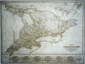
A reproduction of a "Map of the Province of Ontario Showing Railways now Running." A series of Toronto business advertisements line the bottom of the map. Originally published by the Canadian Almanac in 1884. Reproduced by COPP Clark Professional in January 1997 for the celebration of 150 continuous years of almanac and directory publishing.
A map of Ontario to eastern Quebec entitled "Surveyed for Settlement." Produced to commemorate the organization's centennial 1892-1992. Pictures and stories of early surveying surround the map. Scale 1:2,775,000.
A reproduction by Canada Heritage Publications of the "Map of United Counties of Frontenac Lennox Addington, Canada West." Originally published by H. F. Walling of Putnam & Walling in Kingston - 1860. Includes the townships of Adolphustown, North/South Fredericksburgh, Richmond, Ernestown, Camden, Portland and Amherst Island. The names of proprietors are written in lots.
A research project entitled "Ontario and its Subdivisions 1788-1867" by J. L. Morris of the Department of Lands & Forests. 9 maps of Ontario (and parts of Quebec) show the evolution of settlements. The maps are reproductions of originals held at the National Archives of Canada.
Written on the inside cover is "This display for Genealogical reference was mounted and displayed by C. Gordon Crouse of Shawville, Quebec, especially for the O.G.S. Seminar, Guelph, 1968..."
Reproduction of: "A plan of the organized part of the Provinces of Upper Canada according to a Bill which has passed the two Houses, & reserved for the signification of the Royal Pleasure." Surveyed by J. R. Grant Surveyor General. Circa 1798-1802.
A map entitled "A Close Up of Southern Ontario, Ontario, and Canada" by the National Geographic Society's Cartography Section. Scale: 1 centimeter = 30 kilometers or 1 inch = 47.3 miles. Dated December 1978.
A map showing all of Canada by the National Geographic Society's Cartography Section. Scale: 1 centimeter = 69 kilometers or 1 inch = 109 miles. Dated November 1985.
A map showing the Great Lakes of Canada and the USA, by the National Geographic Society's Cartography Section. The totally area shown includes west Manitoba to east Quebec and north to Lake Nipigon and south to U. S. A. Scale: 1 centimeter = 23 kilometers or 1 inch = 36 miles. Dated July 1987.
A map showing the gateways of the Atlantic Ocean in North America, by the National Geographic Society's Cartography Section. Scale: 1 centimeter = 13.2 kilometers or 1 inch= 20.8 miles. Dated March 1983.
A map of all of Canada and the boreal forest included within. Additional environmental information can be found on the borders. Composed by the Canadian Department of Natural Resources. Published by Canadian Geographic in 1996.
A map of Ontario detailing sports and activities located within the "Heart of Canada - Ontario - [an] easy to reach vacation land!" The "things to see & do" are located at different stops along the Trans-Canada Highway. Map dated 1961. Published for free distribution by the Department of Travel & Publicity of the Province of Ontario.
A map of Central Canada detailing various roads, towns and cities. The total area extends from west Sarnia to east Prescott and north Algonquin Park to south Lake Ontario. Map dated 1939. Published by Imperial Oil Limited. Scale: 15 miles to 1 inch.
"The Only Railway Serving All Ten Provinces of Canada:" a map showing the Canadian National Railway System in 1952. The map includes: Canadian National Railways, Grand Trunk Western Railroad Company, Central Vermont Railway Inc., Duluth, Winnipeg and Pacific Railway Company. Composed by C.N.R. Montreal. Scale 10/16 of an inch to 50 miles.