A certified reproduction of the "Subdivision Eastview Heights, part of Lot # 13, Concession 1, Township of Thurlow now City of Belleville.” The area includes; north of Victoria Avenue being Lots # 1 to 25, Blocks A-B laid out on Edge Hill Road, Kingsway Court, Victoria Avenue, and Haig Road. Surveyed by Thomas S. Ransom, O. L. S. and signed May 17, 1963.
An Electoral Map of the Province of Ontario, including all of the electoral districts outlined in red. Composed by Surveyor General F. W. Beatty. Published by the Ontario Department of Lands & Forests in 1955. Scale 8 miles to an inch.
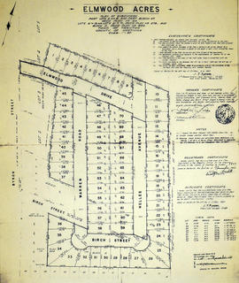
A certified reproduction of the "Elmwood Acres Subdivision of part Lots # 3 & 4, part of Birch Street...Town of Trenton, County of Hastings.” The area includes; Lots # 1 to 70, west of the Township of Sidney and east of Byron Street, being Lots on Elmwood Drive, Warren Road, Nelles Avenue and Birch Street. Surveyed by John Thomas Ransom, O. L. S. and signed October 8, 1960.
A certified reproduction of the "Elmwood Burial Ground on Lot # 6, Concession 4, Thurlow Township designed & subdivided by – Engelhardt Landscape Gardener and adopted by Thomas O. Bolger, P. L. S. (certified by Caleb Reid)." Dated December 18, 1874.
This copy was made in 1972 of plan #181, as registered in the Hastings Land Registry Office.
A reproduction of an air survey photograph produced by the Ontario Ministry of Natural Resources. Map #446772E of Elzevir Township in Hastings County, Ontario. Circa 1950.
The photograph shows the North East part of Elzevir Township, Elzevir Creek and the Skootamata River.
Donated by Walter I. Watson, P.L.S.
Ontario. Ministry of Natural Resources and Forestry
A reproduction of an air survey photograph produced by the Ontario Ministry of Natural Resources. Map #446772W of Elzevir Township in Hastings County, Ontario. Circa 1950.
The photograph shows the Black River Watershed, North West Elzevir Township, North East Madoc Township, South West Grimsthorpe Township, South East corner of Tudor Township.
Donated by Walter I. Watson, P.L.S.
Ontario. Ministry of Natural Resources and Forestry
A original engineer's drawing of a bridge at Downings Rapids across the River Moira. Located east of Madoc and Moira Lake on Rapids Road - Lot # 3, Concession 14, Hungerford Township. Scale 10 feet to an inch.
Donated by the Glanmore National Historic Site in April 2016.
A certified reproduction of the "Extensions to Reid Cemetery, Thurlow Township, part of Lot # 6, 4th Concession.” Surveyed by Fred W. Wilkins, O. L. S. of Evans & Evans, Civil Engineers & Ontario Land Surveyors. Signed August 3, 1918.
This copy was made in 1972 of plan #572, as registered in the Hastings Land Registry Office.
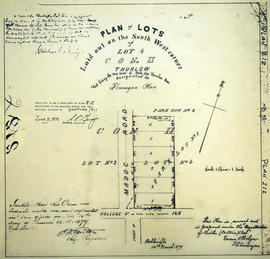
A certified reproduction of the "Finnegan Plan - Lots laid out on the southwest corner of Lot # 4, Concession 2, Thurlow and being the west part of Park Lot # 1, for Michael Finnegan.” Surveyed by Evans and Bolger, P. L. S. and dated March 14, 1879.
This copy was made in 1972 of plan #212, as registered in the Hastings Land Registry Office.
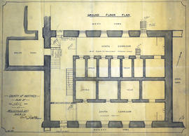
A Floor Plan of the Main First Floor at the County Court House on Pinnacle Street in Belleville, Ontario. All rooms and areas are named: Turnkey's Apartment, Sheriff's Offices, Judge Cameron's Office, Jail Govenor's Office etc. Composed by Charles A. Mott, City Engineer, and dated November 15, 1944.
A blueprint planning the floor of the COR and CPR Union Station at Trenton, Hastings County, Ontario. Drawn by John Dunlop Evans, Chief Surveyor/Engineer - August 23, 1897.
An original hand-painted, paper set of floor plans. The plan was drawn in 1873 for L. W. Yeoman & Company's drug store. The store was located on the corner of Front and Market Streets. The drawings cover the plans for the foundation, ground, second and third floors. Scale: 8 feet to one inch. Published by H. Belden & Company. John Forin built the building.
A plan of the Jail at the Hastings County Court House on Pinnacle Street in Belleville, Ontario. Sheet 1 features old cells and kitchen in basement. Sheet 2 features jail cells in the southeast jail building. Composed by Charles A. Mott, City Engineer, and dated January 1928.
A blueprint planning the suspension footbridge across the Moira River in Belleville, Ontario. Approved by Charles Mott - April 21, 1936. Submitted by Walter H. Patterson of the Patterson Construction Company.
A certified reproduction of the "Forest Hill Subdivision of Part East ½ Lot # 11, Concession 1 Township of Thurlow, prepared for Barbara MacDonell.” The area includes; east of Farley Avenue, from Bridge Street East north to Pine Street, being the east half of Lot # 11, Concession 1, Thurlow Township. Surveyed by John T. Ransom, O. L. S. and signed November 8, 1956.
A study of Front Street Heritage Buildings. The study was completed in 1980 by the Local Architectural Conservation Advisory Committee and funded by the Summer Youth Employment Program. A reference map (in two sheets) corresponds to drawings of buildings labelled A-U.
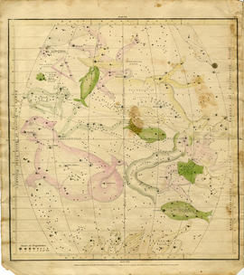
A "Celestial Atlas designed to illustrate the Geography of the Heavens" by Elijah Hinsdale Burritt, an American astronomer and mathematician. This second edition was published in 1833 by F. J. Huntingdon in the Clerk's Office of the District Court of Connecticut. The pages are as follows:
"The visible heavens in October, November and December."
"The visible heavens in January, February and March."
"The visible heavens in April, May and June."
"The visible heavens in July, August and September."
"The visible heavens in the North polar region for each month of the year."
"The visible heavens in the South polar region for each month of the year."
"Planisphere of the whole heavens on Mercator's projection."
A Geological Map of the Madoc Gold Region, 1866. Geological data on map was taken principally from the reports of the Geological Survey of Canada. Secondly, by information and facts obtained on the spot by gentlemen engaged in the gold fields. What follows is a description of the general geological character of the area.
Author: Henry White, P.L.S. Published by G. B. Ware, 16 Toronto Street, Toronto, Ontario.
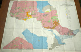
A Geological Map of the Province of Ontario published by the Ontario Department of Mines in 1958. Geology compiled by J. Satterly from published and unpublished maps of the Ontario Department of Mines, the Geological Survey of Canada, mining companies & technical publications (as per Legend). Scale 1 inch to 20 miles.