- CA ON00156 TR/3727
- Unidad documental compuesta
- 1949
File contains a copy of a booklet published for the Centennial of Hastings County celebration held Monday, August 1st, 1949 at the Memorial Park in Tweed.
25 resultados con objetos digitales Muestra los resultados con objetos digitales
File contains a copy of a booklet published for the Centennial of Hastings County celebration held Monday, August 1st, 1949 at the Memorial Park in Tweed.
The file contains a copy of the publication "Journal of the Society for the study of Architecture in Canada" Vol. 30, no. 2, 2005. On pages 25-38 there is an article (with pictures) titled "Joseph Connolly in the Roman Catholic Archdiocese of Kingston, Ontario. It discusses churches in Belleville, Kingston, Kemptville, Prescott, Tweed, Grafton, Gananoque and Picton.
File contains newspaper articles concerning the history of mining in the Tweed area, and in Lennox and Addington County, including explorations for gold in the Flinton area in 1897.
File contains several newspaper clippings concerning miscellaneous events in Tweed including the reorganization of the Chamber of Commerce in December 1956, bridge repairs in 1956 and Tweed's Diamond Jubilee Celebration on August 4-6, 1951.
Tweed : church conference, 1922
File contains a printed brochure entitled “Second Annual Christian Workers' Conference of Madoc District...November 1 and 2, 1922.”
File contains miscellaneous correspondence, statements of accounts and advertising materials of businesses operating in Tweed from 1905-ca. 1930.
File contains a newspaper article concerning the 1896 elopement of Rachael Alberta Tufts and Allan Houser.
File contains a newspaper article (date unknown) recounting an attempted robbery and shooting in Tweed on the 27th-October-1898. The victim of the shooting, Mr. H.S. Perry, the local butcher, survived.
File contains original Letters Patent incorporating "The Ontario Powder Company (Limited)" : Francis Nugent, William Wright, George Easterbrook, William Thomas Easterbrook.
File contains a newspaper article dated 20-November-1961 titled "Fire Completely Destroys Tweed Steel Works Plant".
File contains a number of newspaper articles about Ontario's smallest jailhouse in Tweed, Ontario
Tweed - Service Clubs Invitations and Programmes
File contains: a programme 1912-1913 For Tweed Branch, East Hastings, Woman's Institute; invitation I.O.O.F. 1912 to Dr. C.M. Reeves; meeting invitation to Tweed Lodge A.F.&A.M. No., 239 1914-5-1916.

Map of Hastings with the Principal Villages and the City of Belleville
Parte deMap collection
A map of Hastings County including the Town of Belleville and other principal villages:
Trenton, Madoc, Marmora, Tweed, Bridgewater, Stirling, Wicklow, Bangor, Herschel, Monteagle, Carl, Dungannon, Wollaston, Limerick, Cashel, Tudor, Grimsthorpe, Elzevir; Rawdon, Huntingdon, Hungerford, Sidney, Thurlow, Tyendinaga.
Scale: 3 miles =1 inch. Published by Evans & Bolger, P. L. Surveyors, P.L.S. in 1879-1880.
Sin título

Map of Hastings with townships
Parte deMap collection
A map of Hastings County outlining the twelve townships:
Marmora and Lake, Madoc, Tudor, Grimsthorpe, Elzevir; Rawdon, Huntingdon, Hungerford, Sidney, Thurlow, Tyendinaga.
As well as, the lots and concessions. Circa 1916.Scale: 4 miles: 1 inch.
Donated by K.G.M. Ross.

Topographical map of Tweed - Canada sheet
Parte deMap collection
A topographical map of Tweed - Canada sheet #31 C/6. Published by the Army Survey Establishment, Department of National Defence in 1933. Scale 1 inch to 1 mile = 1/63,360.
Donated by Gerry Boyce.
Sin título
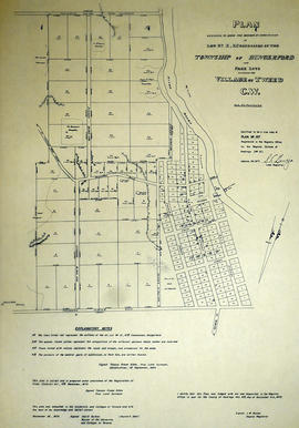
Plan of Lot 10 in the village of Tweed
Parte deMap collection
A certified reproduction of the "Plan of Lot # 10 in Concession 10 of Hungerford Township into Park Lots adjoining the Village of Tweed C. W." The Village of Tweed depicts: grist mill, saw mill, and on opposite side of River: Fulling & Carding Shop. Surveyed by Thomas Fraser Gibbs, P.L.S., and signed September 1, 1864.
This copy was made in 1972 of plan #157, as registered in the Hastings Land Registry Office.
Donated by Walter I. Watson, O.L.S.
Sin título
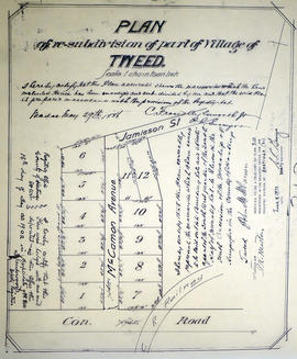
Plan of Lot 11 in the Village of Tweed
Parte deMap collection
A certified reproduction of "Plan of re-subdivision of part of village of Tweed...Part of the southwest quarter of the south half of Lot # 11, Concession 10, Township of Hungerford. Laid out for John M. McCaman.” Surveyed by C. Fraser Aylsworth Jr., P.L.S., and signed May 29, 1886.
This copy was made in 1972 of plan #310, as registered in the Hastings Land Registry Office.
Donated by Walter I. Watson, P. L. S.
Sin título

Photocopy of a Plan of the Village of Tweed
Parte deMap collection
A photocopy of a Plan of the Village of Tweed, Lots # 11 & 12, Concession X, Hungerford Township. Surveyed by John D. Evans, P.L.S., circa 1870. Scale 3 chains to an inch. Written on the back is "16 x 16 original at Tweed Museum."
Donated by the Belleville Public Library in 2014.
Sin título

Photograph of students at Victoria School, Tweed
Sin título