Showing 895 results

Archival description
Map collection Image
Print preview Hierarchy View:

895 results with digital objects Show results with digital objects

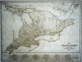
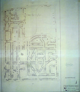
City of Belleville on Acme advertisement

A map of the City of Belleville in 1950, on an advertisement for Acme Plumbing. The map itself features street names and major water ways. Street names are at the bottom of the map. Published by S. A. Renouf Advertising Co. and drawn by F. P. Lloyd. Scale 2" : 2,000 feet.

S. A. Renouf Advertising Co.

City of Belleville on hardware advertisement

A map of the City of Belleville in 1950, on an advertisement for Walker Hardware Company Limited. The map itself features street names and major water ways. Street names are at the bottom of the map. Published by S. A. Renouf Advertising Co. and drawn by F. P. Lloyd. Scale 2" : 2,000 feet.

S. A. Renouf Advertising Co.

CNR Crossing at Cannifton Road Blueprint

A blueprint planning the CNR crossing and gas mains at Cannifton Road in Belleville, Ontario. Drawn by Charles Mott - September 21, 1929. Scale: 1" : 4'0.
Features: 4/4/59 Canadian National Railways Agreement as to Laying Pipes Under Track.

Mott, Charles Allan

Commercial Bank Subdivision of Lots 11-19 in Belleville

A certified reproduction of the "Commercial Bank Plan of subdivision of Lots # 11, 12, 13, 14, 15, 16, 17 and 19, of Belleville, being part of Lot # 2 Concession 1 Thurlow." Surveyed by John D. Evans, P.L.S., and dated April 18, 1873.

This copy was made in 1972 of plan #160, as registered in the Hastings Land Registry Office.

Donated by Walter I. Watson, O.L.S.

Evans, John Dunlop, P.L.S.

Copy of a Map of the Province of New York and Jersey

A reproduction of "A New & Accurate Map of the Province of New York and Part of the Jerseys, New England and Canada. Showing the Scenes of our Military Operations during the Prejant War- Also the New Erected State of Vermont." Originally published by J. Bow on October 31, 1780. Date of reproduction is unknown.

Donated by the Belleville Public Library in 2014.

Copy of a Map of the Province of Ontario showing Railways

A reproduction of a "Map of the Province of Ontario Showing Railways now Running." A series of Toronto business advertisements line the bottom of the map. Originally published by the Canadian Almanac in 1884. Reproduced by COPP Clark Professional in January 1997 for the celebration of 150 continuous years of almanac and directory publishing.

Donated by the Belleville Public Library in 2014.

Copp Clark Limited

COR Station at Bannockburn Plans

A blueprint planning the COR station at Bannockburn, Hastings County, Ontario. Plan features floor, platform plans, elevation and sections. Drawn by John Dunlop Evans, Chief Surveyor/Engineer - July 19, 1902.

Evans, John Dunlop, P.L.S.

COR Station at Bloomfield Plans

A blueprint planning the COR passenger station at Bloomfield, Hastings County, Ontario. Plan features floor, platform plans, elevation and sections. Drawn by John Dunlop Evans, Chief Surveyor/Engineer - July 24, 1909.

Evans, John Dunlop, P.L.S.

COR Station at Ormsby Plans

A blueprint planning the COR Bancroft extension station at Ormsby junction, Hastings County, Ontario. Plan features floor, elevation and sections. Drawn by John Dunlop Evans, Chief Surveyor/Engineer - September 1, 1900.

Evans, John Dunlop, P.L.S.

COR Station at St. Ola Plans

A blueprint planning the COR station at St. Ola, Hastings County, Ontario. Plan features floor, elevation and sections.

Corporation of Thurlow Map of Roads

A map from the Corporation of the Township of Thurlow showing Ontario Hydro lines, concessions and additional country roads. Circa 1970.
Donated by the City of Belleville.

Croydon's Map of the City of Belleville

A map of the City of Belleville, circa 1932, showing railroads, streets, bus roues, city limits and highways. Also featured is a street index. Published by the Croydon Map Company and drawn excursively for the Rural Township Map Company.

Donated by the Belleville Public Library in 2014.

Croydon Publishing Co.

Depth of the Moira River for Channel Plan

A map showing, primarily, the depth of the Moira River within Belleville, Ontario. Together with a written report, it proposed a channel to the New Ferry Slip. Major streets and some lots are also labelled. By John D. Evans, P.L.S. on April 28, 1881 or 1887. Scale: 66 feet : 1". Note the interesting colouring at dimmed edges.

Donated by the Col W. N. Ponton Estate.

Evans, John Dunlop, P.L.S.

Diagram of Town plot called Trent Port

A copy of an original map by Deputy Provincial Surveyor F. P. Rubidge showing a diagram of a town plot at the mouth of the Trent River called the "Town of Trent Port." Specifically, the map shows Lot 2 near the 1st Concession bordering Murray Township in the County of Northumberland.
Published in Cobourg on September 25, 1852.
Donated by K.G.M. Ross.

Rubidge, Frederick Preston, D.P.S.

Dominion of Canada with Hudson's Bay areas

A Map of the Dominion of Canada Shewing the Establishments of the Hudson's Bay Company. Scale: 1:10,500,00. Note the presence of the Districts of Mackenzie, Keewatin and Franklin and the border of Manitoba - circa 1905.

East City of Belleville Map with Property Boundaries in 1976

A map of the City of Belleville, including property boundaries, waterways and roads. House numbers are also included. From Bridge Street East north to Station Street and from the Bleecker Avenue east to Herchimer Avenue. Map composed by the Quinte Planning Board and dated February 23, 1976. Scale 1:2400.

Donated by the Heritage Belleville Committee in 2017.

Quinte Planning Board

East Gate Subdivision in the City of Belleville

A certified reproduction of the "Subdivision of Part of East ½ of Lot # 13, Concession 1, Township of Thurlow, now Belleville laid out for Maple View Realty Ltd. Pres. Maurice Rollins.” The area includes; Lots # 1 to 110 and Blocks A, B, C, D, E, F and Haig Road, Joyce Crescent, Richmond Grove, Janlyn Crescent, Whalen Court, all east of Haig Road. Surveyed by Walter I. Watson, O. L. S. and signed February 10, 1964.

Donated by Walter I. Watson, P. L. S.

Watson, Walter Irvine, O.L.S.

East Park Subdivision in the City of Belleville

A certified reproduction of the "East Park Subdivision, part of east half of Lot # 13, Concession 1, formerly Township of Thurlow, now Belleville - owner Lambert Rollins Construction.” The area includes; Lots # 1 to 47, Block A-C, east of Haig Road, with Bridge Street East, Joyce Crescent, Freemont Road. Surveyed by T. S. Ransom O. L. S. (of Ransom & Watson, O. L. S.) and signed April 21, 1965.

Donated by Walter I. Watson, P. L. S.

Ransom, Thomas Saunders, P.L.S.

Results 41 to 60 of 895