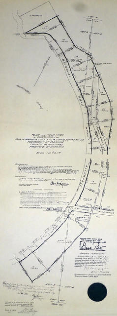
A certified reproduction of the "Subdivision of part of Broken Lot # 25 in Concession 8 and parts of Lot # 24 and Broken Lot # 25 in Concession 9, Township of Bangor.” The area includes; west shore of Kaminiskeg Lake, on parts of Lots # 24 and 25 in Concession 8 and 9, Bangor Township. Surveyed by John E. C. Butterfield, O. L. S. and signed August 27, 1948.
A certified reproduction of the "Subdivision of Parts of Broken Lots # 3 & 4, Concession 8 & 9, Township of Bangor.” The area includes; water lots on Papineau Lake, Block A & B and Lots # 1 to 11, including Lots # 5A, 6A, 7A. Surveyed by John E. C. Butterfield, O. L. S. and signed June 23, 1948.
A certified reproduction of the "Earls Court Subdivision part of Lots # 15 & 15, Reg. Plan 198, City of Belleville...owner R. H. Breault and Marian Vivien Breault” The area includes; Lot # 1 to 19 on Walmsley Place in the Earls court Subdivision East of Avondale Road.. Surveyed by Walter I. Watson, O. L. S. and signed December 15, 1968.
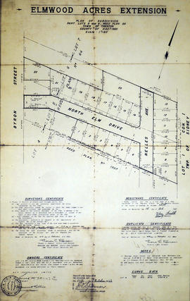
A certified reproduction of the "Subdivision “Elmwood Acres Extension”, part [of] Lots # 5 & 6, Reg'd Plan No. 64, Town of Trenton- owner B E P Construction Ltd.” The area includes; west of town limits for the town of Trenton, west to Byron Street, Lots # 1 to 23 and Blocks A, B, C on North Elm Drive and Nelles Ave. Surveyed by Thomas S. Ransom, O. L. S. and signed February 14, 1963.
A certified reproduction of the "Subdivision of Part of Foster Town Plan, Belleville, for owner [with surname] Reid” Surveyed by Evans & Evans, C. E. & O. L. S., and signed July 12, 1911.
This copy was made in 1972 of plan #415, as registered in the Hastings Land Registry Office.
A certified reproduction of the "Plan of subdivision of part of free grant Lots # 39 & 40. Lying east of the Old Hastings Road, Township of Limerick (on line between Concession 7 & 8) for Alexander Menzies.” Dated May 26, 1885.
This copy was made in 1972 of plan #244, as registered in the Hastings Land Registry Office.
A certified reproduction of the "Subdivision [of] “Greenfield Park”- part of Lots # 3 & 4, Concession IV, Township of Thurlow.” The area includes; Lots on Ross Crescent along the Moira River south of River Road. Surveyed by Ronald Benn, O. L. S. and signed September 30, 1963.
A certified reproduction of the "Subdivision of island opposite Lot # 24, Concession IV, Township of Cashel, over High Pine Developments.” The area includes; Gunter Lake island Lots # 1 to 16 and Block A-B being opposite of Lot # 24, Concession IV, Township of Cashel. Surveyed by David M. Bews, O. L. S. (of McAlpine & Bews, O. L. S.) and signed July 13, 1966.
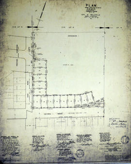
A certified reproduction of the "Subdivision of part of Block 3, Reg'd Plan No. 25, City of Belleville, prepared for B. E. P. Construction Ltd.” The area includes; north from C. N. Railway to Evans St. and west from North Front Street to Coleman Street. Surveyed by Thomas S. Ransom, O. L. S. of Ransom & Watson, O. L. S. and signed February 20, 1963.
A certified reproduction of the "Subdivision of part Lots # 10 and 11, Reg'd Plan No. 63, Township of Thurlow, now City of Belleville, owner Demille Construction Ltd.” The area includes; north of Victoria Avenue and west of Herchimer Avenue, Lots # 1 to 30 on Leslie Drive and Victoria Avenue. Surveyed by Thomas S. Ransom, O. L. S. and signed May 25, 1962.
A certified reproduction of the "Subdivision of Lot # 1, Concession 10 & 11, Township of Wicklow, for Dept. Lands & Forests.” The area includes; Lots # 1 to 5 and Block 'A' on the northeast shore of Papineau Lake in Wicklow Township. Surveyed by Michael J. McAlpine, O. L. S. and signed December 1, 1960.
A certified reproduction of the "Subdivision of part of the West ½ of Lot # 13, Concession 1, Township of Thurlow, now Belleville, owner Lambert-Rollins Construction Ltd.” The area includes; Block A, Lots # 1 to 41, Diamond Crescent, Flint Driver, and Haig Road. Surveyed by Walter I. Watson, O. L. S. and signed December 29, 1972.
A certified reproduction of the "Subdivision of part of East ½ Lot # 13, Concession 1, Township of Thurlow, now Belleville.” The area includes; Lots # 1 to 14, Block A, B, C, and East of Haig Road and North of Victoria Ave. Surveyed by Walter I. Watson, O. L. S. and signed December 8, 1970.
A certified reproduction of the "Subdivision of north half of Lot # 13, Reg'd Plan No. 769, County of Hastings, City of Belleville, formerly Township of Thurlow, [for] owners Ernest A. and Ada C. Hughes.” The area includes; Lots # 1,2, 3, south of Auburn and east of Sidney Streets. Surveyed by Thomas S. Ransom of Ransom & Watson, O. L. S. and signed July 24, 1965.
A certified reproduction of the "Subdivision of Lot # 22 - east side of West Street in Trenton, for Alexander Miron.” Surveyed by Evans & Evans, Civil Engineers & O. L. S. and signed May 15, 1917.
This copy was made in 1972 of plan #474, as registered in the Hastings Land Registry Office.
A certified reproduction of the "Subdivision of Lot # 27, Reg'd Plan no. 852, City of Bellleville, owners Neil A. McMillan & Anna Amelia McMillan.” The area includes; Lots # 1 to 4 West of Adrian Street and North of Maple Drive. Surveyed by Walter I. Watson, O. L. S. and signed February 15, 1969.
A certified reproduction of the "Plan of Subdivision of Part Lot # 35, Concession 1 Sidney owner Frank Follwell.” The area surveyed includes; Part Lot # 35, Concession 1, Sidney Township, Lots on both sides of Wright Avenue and Glen Road. Surveyed by John T. Ransom, O. L. S. and signed March 10, 1955.
This copy was made in 1972 of plan #982, as registered in the Hastings Land Registry Office.
A certified reproduction of the "Subdivision of Lot # 36, Reg. Plan No. 852, City of Belleville, owner William James Forgie & Audrey Forgie.” The area includes; Lots # 1 & 2 and Block A, B, C South of Maple Drive & West of Yate Street being near Lemoine Street on the East. Surveyed by Walter I. Watson, O. L. S. and signed December 3, 1970.
A certified reproduction of the "Subdivision of Lot # 6, east of North Park Street, Government Plan,Township of Thurlow.” The area includes; east of North Park Street and both sides of North Park Gardens. Surveyed by John Thomas Ransom, O. L. S. and signed August 25, 1948.
A certified reproduction of the "Plan of Subdivision of part of Lot A, Concession IV, Township of Sidney, prepared for Bata Shoe Co. of Canada Ltd.” The area surveyed includes; Lot A, Concession IV, south of Bata Road and west of Frankford Road being Lots in Sidney Crescent. Surveyed by John T. Ransom, O. L. S. and signed July 2, 1955.
This copy was made in 1972 of plan #993, as registered in the Hastings Land Registry Office.