- CA ON00156 TR/3268
- Item
- c. 1953
This file contains a copy of notes from Ray Moran on the history of Frankford.
28 results with digital objects Show results with digital objects
This file contains a copy of notes from Ray Moran on the history of Frankford.
Discovery and Exploration of the Bay of Quinte
This file contains a copy of a letter received from Public Archives of Canada with a Xerox copy of an article by J.H. Coyne entitled "Discovery and Exploration of the Bay of Quinte" published in Ontario Historical Society, Papers and Records, Vol. 5, 1904.
Scrapbook on the history of Hastings County, Moira Valley.
This file contains a scrapbook created by Bruce Dobbs on the history of Hastings County, Moira Valley. Articles from the Intelligencer.
Midland District Hastings County Report on Roads, Crt. of Quarter Sess. 1810-30
This file contains a ledger recording roads passed in the Midland District in the County of Hastings from 1810 to 1830. Allan McLean Esq. was acting as Clerk of the Peace of the District. https://en.wikipedia.org/wiki/Allan_McLean_(Upper_Canada_politician)
these were recorded by James Nichollas, Clerk of the Peace, Midland District.
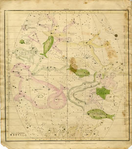
Geography of the Heavens - a Celestial Atlas
Part of Map collection
A "Celestial Atlas designed to illustrate the Geography of the Heavens" by Elijah Hinsdale Burritt, an American astronomer and mathematician. This second edition was published in 1833 by F. J. Huntingdon in the Clerk's Office of the District Court of Connecticut. The pages are as follows:
Burritt, Elijah Hinsdale
Archaeological – Rev Bowen Squire, Quinte Area
File contains a Northeast Archeology Booklet, letters, and a list of references.
Realtor's Map of Belleville, Quinte West, Prince Edward & Disitrct
Part of Map collection
A map featuring the streets in Belleville (includes Belleville & Thurlow Wards), Quinte West (includes Trenton, Sidney, Murray & Frankford Wards), Prince Edward & District including Brighton, Campbellford/Seymour, Colborne, Deseronto, Centre Hastings, Madoc, Marmora, Stirling/Rawdon, Tweed, Tyendinaga.
Quinte and District Real Estate Board
Part of Map collection
A double-sided map of the accommodations, camping and attractions located in Land O' Lakes. Includes North & West of Kingston including Napanee, the Frontenacs, Loyalist Country & Mazinaw Country. Advertisements surround the map. Dated 1982.

Road Map of Hastings County 1956
Part of Map collection
A road map of Hastings County in 1956. Portions of adjoining counties are also pictured. Boundaries are yellow, while roads are blue and red. Published by the Ontario Department of Highways. Scale: 1 inch = 4 miles. Dimensions: 72cm x 46.5cm.
Donated by Vera Crabbe in 2008.
Ontario. Department of Highways
Road Map of the Province of Ontario 1964
Part of Map collection
A road map of the northern and southern portions of the Province of Ontario. Published by the Ontario Department of Highways in 1964. Various indexes and legends are located on the map.
Ontario. Department of Highways

Resources Map of Hastings County
Part of Map collection
Resources map of Hastings County, Ontario, showing agricultural activity and natural resources.
Map of Crowe Lake Waterway Association
Part of Map collection
3 copies of a map of the Crowe Lake Waterway Association in the Municipality of Marmora and Lake. The map shows major highways, islands, water ways and bodies of water including; Highway 7, Big Island, Crowe Lake, Crowe River etc. Also includes some topographical levels.
Wine Tour Map of Prince Edward County
Part of Map collection
A map of Prince Edward County showing the location and information about local wineries.
Map of Belleville on the Bay of Quinte 2014-2015
Part of Map collection
A Map of Belleville on the Bay of Quinte, also including the surrounding areas of Picton in Prince Edward County. Advertisements border the map
Belleville Chamber of Commerce
Part of Map collection
The map is entitled "Comfort Country" and highlights vacation areas in Stirling, Tweed, Madoc, Marmora. Advertisements on back with numbers to show on Map where it is located.
Madoc and District Chamber of Commerce
Part of Map collection
The map is entitled "Comfort Country" and highlights vacation areas in Coehill, Ormsby, Gilmour and the surrounding areas. Advertisements on back with numbers to show on Map where it is located.

Map of Hastings County and Road Changes
Part of Map collection
A map of Hastings County in 1914. Roads to be removed are highlighted in red colour. Published by the Office of Public Roads and Highways. Scale: 2 miles = 1". Dimensions: 54cm x 87cm.
Donated by Eric Jones, accession #2015-49.
Office of Public Roads and Highways

Map of the Great Lakes with French Missionary notes
Part of Map collection
A map of Lake Ontario and the land surrounding it, with notes, presumably written by French explorers. Original date 1670, reprinted July 7, 1882.
Part of the Mika collection.
Railways and Canals of Eastern and Western Canada
Part of Map collection
1) A map of the Railways and Canals of Eastern Canada in 1971. Index #203 and 204 as published by the Department of Energy, Mines and Resources. Scale 1:7,500,00 or one inch to 118.37 miles. Includes area from Ontario to Newfoundland.
2) A map of the Railways and Canals of Western Canada in 1971. Index #205 and 206 as published by the Department of Energy, Mines and Resources. Scale 1:7,500,00 or one inch to 118.37 miles. Includes area from British Columbia to Ontario.
Canada. Department of Energy, Mines and Resources
Reproduction Map of Carte de la nouvelle France
Part of Map collection
A reproduction of Carte de la nouvelle France by Samuel de Champlain in 1652. Includes regions to Virginia, from Newfoundland to Lake Superior.
Archives of Ontario