A map of heritage buildings, using Goad's Fire Insurance Maps from 1904-1908, in the East Hill area of Belleville, Ontario. Prepared by the Local Architectural Conservation Advisory Committee in 1985. A colour chart dictates red for first priority; yellow for important to the street scape; blue for lost heritage; green for open areas.
Reproduction of an 1874 Bird's Eye View of Napanee, Ontario, showing buildings that existed at that time. The original map was drawn by Herman Brosius and printed by Charles Sober & Co. of Chicago.
14 blueprints planing for the rebuilding of John Street United Church on Victoria Avenue in Belleville, Ontario. Scale 1.25" = 1 foot. By 1) Wm. Watson, architect 2) Pease Foundry Company, Charlie Hyde.
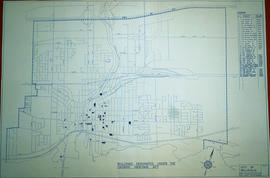
A map of the Buildings Designated under the Ontario Heritage Act in Belleville, Ontario. Created by the Heritage Belleville Committee on November 22, 1985 and revised February 14, 1994. The area includes; the Bay of Quinte north to Highway 401 with designations in the area between Sidney Street and McDonald Avenue.
A copy of a map planning streets and buildings in Belleville, Ontario, 1892. The total area extends from Belleville to Bay of Quinte to Bridge Street (sheet 2) and from Bridge Street to Concession Road Allowance - now College Street - (sheet 1). Surveyed by Henry Carre, Ontario Land Surveyor.
A Floor Plan of the Main Cell Block and Basement at the County Court House on Pinnacle Street in Belleville, Ontario. The “Old Cells” are in the basement of the Court House. The Main Cell Block is connected to the Court House on the southeast. Composed by Charles A. Mott, City Engineer, and dated November 15, 1944.
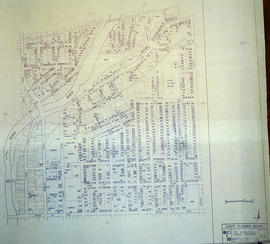
A map of the City of Belleville, including property boundaries, waterways and roads. House numbers are also included. From Bridge Street East north to Station Street and from the Moira River east to Bleecker Avenue. Map composed by the Quinte Planning Board and dated February 23, 1976. Scale 1:2400.
Donated by the Heritage Belleville Committee in 2017.
A hand-drawn map of Belleville, Ontario in 1950. The map itself features street names and major water ways. Advertisements surround the map. Published by S. A. Renouf Advertising Co. and drawn by F. P. Lloyd. Scale 1:15,000.
A map of the City of Belleville, including property boundaries, waterways and roads. From the Moira River in the east to the Bay of Quinte south and CNR & North Front Street in the north to Avondale Road in the west. Map composed by the Quinte Planning Board and dated October 1, 1981. Scale 1:4800.
Donated by the Heritage Belleville Committee in 2017.
A map of the City of Belleville in 1950, on an advertisement for Acme Plumbing. The map itself features street names and major water ways. Street names are at the bottom of the map. Published by S. A. Renouf Advertising Co. and drawn by F. P. Lloyd. Scale 2" : 2,000 feet.
A map of the City of Belleville in 1950, on an advertisement for Walker Hardware Company Limited. The map itself features street names and major water ways. Street names are at the bottom of the map. Published by S. A. Renouf Advertising Co. and drawn by F. P. Lloyd. Scale 2" : 2,000 feet.
A blueprint planning the CNR crossing and gas mains at Cannifton Road in Belleville, Ontario. Drawn by Charles Mott - September 21, 1929. Scale: 1" : 4'0. Features: 4/4/59 Canadian National Railways Agreement as to Laying Pipes Under Track.