Showing 2938 results

Archival description
Belleville
Print preview Hierarchy View:

625 results with digital objects Show results with digital objects

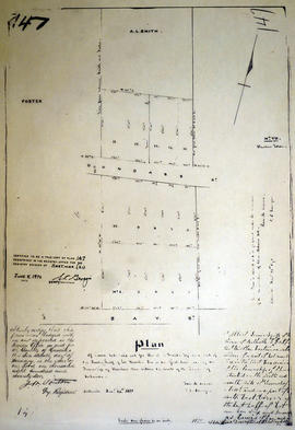
Plan of the town of Belleville 1864-65

A copy of a map planning streets and some buildings in Belleville, Ontario, 1864-65. Composed by R. L. Innes, ESQ. C.E. Produced for the Hastings Directory.

Scale: 10 chains to an inch.

Plan of the town of Belleville 1869

A copy of a map planning streets and some buildings in Belleville, Ontario, 1869. Produced for the Hastings Directory. Map shows location of schools, court house, churches, banks, post office, town hall, police station, important industries.

Scale: 10 chains to an inch.

Plan of town lots for A. L. Smith in the town of Belleville

A certified reproduction of the Plan of Town lots laid out for A. L. Smith on the south half of Lot # 6 in 1st Concession of Thurlow, now within the limits of Town of Belleville. The Foster lot is to the west and the Bleecker Estate to the east. Surveyed by Samuel M. Benson, P.L.S. and signed November 24, 1871.

This copy was made in 1972 of plan #147, as registered in the Hastings Land Registry Office.

Donated by Walter I. Watson, O.L.S.

Benson, Samuel Manson, D.P.S. & P.L.S.

Plan of Town Lots on Lot 6 in the town of Belleville

A certified reproduction of the Plan of Town Lots # 6 in 1st Concession of Thurlow, Belleville, proprietors Charles George LeVisconte & Albert Lewis Smith. The letter “L” marks the subdivided lots owned by LeVisconte. Surveyed by John Emerson, P.L.S. in July 1856.

This copy was made in 1972 of plan #87, as registered in the Hastings Land Registry Office.

Donated by Walter I. Watson, O.L.S.

Emerson, John, P.L.S.

Plan of Vair's Block

Plan of Vair's Block registered in the Hastings County Land Registry Office, showing Lots # 22 & 23 North side of Bridge Street & Lot # 15 West side of Town Line Street in Belleville, Ontario. The plan was drawn up John James Haslett, Provincial Land Surveyor, in November 1869.

Haslett, John James, P.L.S. & D.P.S.

Plan of Wallbridge Estate in the town of Belleville

A certified reproduction of the Plan of the Wallbridge Estate on Lot # 2, Concession 1, in the Township of Thurlow, now Belleville. Notes made by W. W. Dean, Master in Chancery at Belleville in Chancery, and between the Hon. Lewis Walbridge (plaintiff), Lillian Halloway Wallbridge and others (Defendants). Surveyed by John D. Evans, P.L.S. and signed January 26, 1872.

This copy was made in 1972 of plan #148, as registered in the Hastings Land Registry Office.

Donated by Walter I. Watson, O.L.S.

Evans, John Dunlop, P.L.S.

Plan of west side of Front Street

A map of the planned west side of Front Street in Belleville, Ontario, 1854. By John J. Haslett, P.L.S.

Haslett, John James, P.L.S. & D.P.S.

Plan of Wilkins Block in Belleville, 1850

A certified reproduction of the "Plan of Wilkins Block - Lot # 22 & 23 on the west side of Pinnacle Street in Belleville." Surveyed by John J. Haslett, P.L.S. and signed March 1850.

This copy was made in 1972 of plan #10, as registered in the Hastings Land Registry Office.

Donated by Walter I. Watson, O.L.S.

Haslett, John James, P.L.S. & D.P.S.

Plan of Wilkins Block in the town of Belleville, 1848

A certified reproduction of the Plan of Wilkins Block composed of Lots # 22 & 23 on the west side of Pinnacle Street in Belleville. Property of Joseph Shuter and the Hon. Robert Charles Wilkins. Surveyed by John J. Haslett, P.L.S. and signed in March 1848.

This copy was made in 1972 of plan #35, as registered in the Hastings Land Registry Office.

Donated by Walter I. Watson, O.L.S.

Haslett, John James, P.L.S. & D.P.S.

Plan of Willard Block in Thurlow

A certified reproduction of the “Willard Block.” A plan for part of Lot # 2 in the First Concession of Thurlow, [now Belleville] surveyed for Julia Willard. The area contained includes; 20 Lots bounded by Bridge St. West, Highland Ave., Ann Street and Willard St., being part of Lot # 2 Concession 1 Township of Thurlow. Originally surveyed by J. J. Haslett, P. L. S. and produced on August 23, 1848.

Haslett, John James, P.L.S. & D.P.S.

Plan of William Bleecker Block in Belleville

A certified reproduction of the "Plan of part of Lot # 3, Concession 2, Thurlow Township, property of William Bleecker – being the William Bleecker Block." Surveyed by John D. Evans, P.L.S., and signed November 24, 1873.

This copy was made in 1972 of plan #163, as registered in the Hastings Land Registry Office.

Donated by Walter I. Watson, O.L.S.

Evans, John Dunlop, P.L.S.

Plan of Yeomans Blocks B-C in the town of Belleville

A certified reproduction of the Plan of Block C and part of Block B on plan of town lots for Asa Yeomans. Part of the north half of Lot # 1 in 1st Concession of Thurlow. Surveyed by John Emerson, P.L.S. and signed July 1871.

This copy was made in 1972 of plan #144, as registered in the Hastings Land Registry Office.

Donated by Walter I. Watson, O.L.S.

Emerson, John, P.L.S.

Plan Showing A Development at Belleville, Ontario

"Plan Showing a Development at Belleville, Ontario, Canada." Includes the proposal of 3 urban areas labelled A, B, & C, and the proposed building of an international airport and casino. Drawn at the City Engineer's Office and signed February 1925.

Mott, Charles Allan

Plans for Centennial Secondary School

A set of general plans for two floors of Belleville's fourth high school - Centennial Secondary School. Published by Barnett and Rieder June 21, 1965. Scale: 1/16" : 1'2".

Barnett & Rieder

Plans for Intelligencer and CJBQ Radio Station

  • CA ON00156 M/M450-2127 - 2158
  • Series
  • Jul 1963 - 2 Oct 1977
  • Part of Map collection

A series of architectural drawings for the Ontario Intelligencer Limited and C. J. B. Q. Radio Station;
From July-August 1963, plot, floor and interior plans.
From April 1964, floor, elevations, walls, windows, stairs, and entrance plans.
From 1977, foundations and alteration plans.

Barnett and Rieder Architects

Plans for Proposed Hastings Heritage Centre

Plans for a Proposed Hastings Heritage Centre in former Thurlow Township Municipal Hall and Offices, located at 154 Cannifton Rd. North. By Gerry Boyce, Susie Boyce, Carson Cross. The former Historical Society and Archives until 2016.

Boyce, Gerry

Plans for Schedules A-F in the City of Belleville

  • CA ON00156 M/M440-1344 - 1349
  • Item
  • Aug 1974 - 1990
  • Part of Map collection

Schedule plans A - F for the City of Belleville. Researched by the Quinte Planning Board. Published by Totten Sims Hubick; Associates Limited. All maps must be read in conjunction with the associative text provided.
1) M440-1344. Dated Jul 1988. Schedule A - Planning Districts and Planning Units. Scale 0-1000:4".
2) M440-1345. Dated Aug 1974. Revised Jan and Oct 1975. Schedule B - Land Use Plan. Scale 1" : 800ft.
3) M440-1346. Dated Aug 1974. Revised Jan and Oct 1975. Schedule C - Recreation Plan. Scale 1: 9600.
4) M440-1347. Dated Aug 1974. Revised Jan and Oct 1975. Schedule D - Residential Density Plan. Scale 1: 9600.
5) M440-1348. Dated Aug 1974. Revised Jan and Oct 1975 and Sep 1986. Schedule E - Transportation Plan. Scale 1: 9600.
6) M440-1349. Dated 1990. Schedule F - Municipal Services Plan. Scale 1: 9600.

Totten Sims Hubicki Associates Limited

Results 2141 to 2160 of 2938