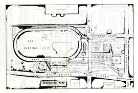
File contains a display space information booklet, a copy of an aerial map of Exhibition park, an application for space at the Belleville exhibition, and the following newspaper clips on the c.1969 Belleville Fair: junior farmers judge livestock, fair hosts children's day, home sewing competition, candy competition at Fair, and other miscellaneous newspaper clips on the c.1969 Belleville Fair.
Belleville Yardmen Benefit Fund lottery ticket, photograph of six members of the Board of the Fund and fifteen colour slides of the Quinte Sports Centre under construction.
A hand-drawn map of Belleville, Ontario in 1950. The map itself features street names and major water ways. Advertisements surround the map. Published by S. A. Renouf Advertising Co. and drawn by F. P. Lloyd. Scale 1:15,000.
A map of the City of Belleville (with Trenton inset) featured in the September 20, 1961 issue of the Ontario Intelligencer. The map features houses that were open that week for viewing. At the bottom are sponsors of the map.
A map of the City of Belleville in 1950, on an advertisement for Acme Plumbing. The map itself features street names and major water ways. Street names are at the bottom of the map. Published by S. A. Renouf Advertising Co. and drawn by F. P. Lloyd. Scale 2" : 2,000 feet.
A map of the City of Belleville in 1950, on an advertisement for Walker Hardware Company Limited. The map itself features street names and major water ways. Street names are at the bottom of the map. Published by S. A. Renouf Advertising Co. and drawn by F. P. Lloyd. Scale 2" : 2,000 feet.
Album pages with photographs of Royal Flying Corps/Royal Air Force activities in Deseronto, Ontario, and some snapshots of local buildings and Cole family members.
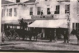
Photocopies and scans of newspaper articles and photographs relating to the Dawson and Burley families. 1) Photocopy of Quinte Scanner article about Hudson’s Mill. December 18, 1981 2) Photocopy of photograph of front of Deseronto House Hotel, with Deseronto Bus Line coach and horses. 3) Photocopy of photos of the old Deseronto to Prince Edward County ferry, being made into a houseboat (Reg Dawson did this) 4) Photocopy of article in The Intelligencer about the ferry from October 30, 1974. Mentions Reg Dawson. 5) Photocopy of photos of the ferry in service. Undated.
Photographs of Deseronto, Ontario dating from the 1970s to 2011, depicting a variety of Town events. They include a set of aerial photographs of the town from the 1980s; the interior of the former Home Hardware store in the Baker Block on Main Street; the O’Connor House on Main Street before its demolition; the 1989 100th Anniversary celebrations, photographs of Centennial Park and Rathbun Memorial Park; the opening of the Deseronto Public Library in its 358 Main Street location in 2001; the Ontario Provincial Police handover ceremony in 2001; an Easter Parade from the early 2000s; a Santa Parade; the 2002 New Year’s Levee; and the 2010 Olympic Flame run in Deseronto.
Most of the photographs appear to have been taken by Town staff. One envelope was donated to the Town by Irene Usher and contains photographs taken by her late husband, Tom.
Photographs: 1) Bev and Vern Boomhour on their wedding day, 28 July 1956 2-10) Quinte Classic boat races in Deseronto in 1980 11) Dignitaries at the entrance to Deseronto Town Hall for the Terry Fox Run in 1982
Typewritten list of names residents of Tweed, Ontario,1902-1920, with their professions, four photographs of the Belleville, Ontario, flood of 1936 and two newsclippings from April 1999 about the Belleville Choral Society.
Sunday school attendance register for Marmora Methodist Church, Marmora, Ontario, including a printed page with an image of the late Canon C. M. Harris, 1854-1923, Rector at Marmora. Also banquet invitation and menu for an event held at the Hotel Quinte for Hastings County councillors on 10th December 1926.
Photographs of scenes in and around Belleville, Ontario, including a circus parade, Lincoln Beachey's aircraft, the talc mine at Madoc and military groups.
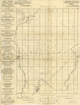
A map showing concessions and lots of Cashel Township, Hastings County. Circa 1869. 13 advertisements for companies are present on the left-hand side. Published by Macleod and Carre, Engineers and Surveyors. Scale: 1:63,000. Dimensions: 29.0cm x 33cm. Map was created from Government plan.
Donated from the Col. W. N. Ponton Estate. Penciled notes on map show Ponton family's interest in mining, especially after the Eldorado Gold Rush in 1866.
A map showing concessions and lots of Elzevir Township, Hastings County. Circa 1869. 16 advertisements are present on the left-hand side. Published by Macleod and Carre, Engineers and Surveyors. Scale: 1:63,000. Dimensions: 29.0cm x 37.5cm.