
The Belleville Directory for 1877
- CA ON00156 CH/13/1/4
- Pièce
- 1877
Fait partie de County of Hastings records
Digital copy of Hoogs & Milette's 1877 directory of Belleville, Napanee, Trenton, and Brighton.
93 résultats avec objets numériques Afficher les résultats avec des objets numériques
The Belleville Directory for 1877
Fait partie de County of Hastings records
Digital copy of Hoogs & Milette's 1877 directory of Belleville, Napanee, Trenton, and Brighton.
Subdivision of Park Lots 10-11 in the Town of Trenton
Fait partie de Map collection
A certified reproduction of the "Subdivision of Park Lots # 10 & 11 and part of Park Lots # 7, 8, 9, 12, 13 Reg. Plan No. 64, Trenton.” The area includes; Lots # 1 to 86, Block A-D and streets Connally Aveune, Shoniker Avenue, Nelles Avenue, being South of Canadian Pacific Railway. Surveyed by Edward C. Carter, O. L. S. (Carter Horwood Ltd. , O. L. S.) and signed July 12, 1971.
Donated by Walter I. Watson, P. L. S.
Sans titre
Plan of Easements Lot 1-86 in Trenton
Fait partie de Map collection
A certified reproduction of the "Compiled Plan of Easements, Part of Lots # 1 to 86 & part of Blocks B & C. Reg. Plan No. 1946, Town of Trenton.” The area includes; East of Byron Street & including Connolly Avenue, Shoniker Avenue, Nelles Avenue. Surveyed by Edward C. Carter, O. L. S. (Carter Horwood Ltd. , O. L. S.) and signed August 13, 1971.
Donated by Walter I. Watson, P. L. S.
Sans titre
Subdivision of Park Lot 19 in the Town of Trenton
Fait partie de Map collection
A certified reproduction of the "Subdivision of Part of Park Lot # 19, Reg. Plan 232, Trenton.” The area includes; Lots # 1 to 16, Blocks “A” and “B”, Streets, Adrian Courtand, Charlotte St. being West of Sidney Street and Northerly of Edward Street. Surveyed by J. Vinkler, O. L. S. and signed August 21, 1973.
Donated by Walter I. Watson, P. L. S.
Sans titre

Hydrographic Map of Plans in Bay of Quinte
Fait partie de Map collection
A hydrographic map of Plans in the Bay of Quinte, Ontario, Canada. 4 inset maps are included of the 1) Trenton and Approaches, 2) Belleville, 3) [Racist slur redacted] Narrows, and 4) Telegraph Narrows. Nautical surveys completed by Col. W. P. Anderson in 1893 and Mr. E. A. Ghysens in 1934. Map printed March 25, 1952. Published by the Canadian Hydrographic Service, Department of Mines and Technical Surveys, Ottawa.
Sans titre

Seymour Power & Electric Co. Limited in Murray Township
Fait partie de Map collection
An original map produced for the Seymour Power & Electric Co. Limited, concerning proposed transmission lines within the Township of Murray. However, the map also features railways, roads, mills and land boundaries. Circa 1910. Scale: 50 chains = 1 inch. Map composed by Smith, Kerry and Chace Engineers located in Toronto, Winnipeg, Calgary and Vancouver.
Donated by David Pershick.
Sans titre

Trenton Electric & Water Co. Limited in Sidney Township
Fait partie de Map collection
An original map produced for the Trenton Electric & Water Co. Limited, concerning proposed transmission lines within the Township of Sidney. However, the map also features railways, roads and land boundaries. Circa 1910. Scale: 50 chains = 1 inch. Map composed by Smith, Kerry and Chace Engineers located in Toronto, Winnipeg, Calgary and Vancouver.
Donated by David Pershick.
Sans titre
Map of City of Quinte West 2007
Fait partie de Map collection
A map of Quinte West, Ontario featuring Frankford, Murray, Sidney and Trenton areas. Dated 2007.
Sans titre
Teacher's Guide to Quinte in 1785
Fait partie de Map collection
Map showing the Bay of Quinte to Presqu'ile to the eastern tip of Grande Isle (Wolfe Island) used as a teacher's guide to the area in 1785. The 20th century names are in capital letters as per the Legend.
Reproduction of Murray Canal Plan
Fait partie de Map collection
"Murray Canal Plan Showing Portions of the Old Canal Reserve Which It is Proposed to Grant to the Province of Ontario."
A reproduction from an original at the Archives of Canada's map collection.
Map of Belleville to North of Bancroft
Fait partie de Map collection
A map containing focused maps of: Trenton, Belleville, Prince Edward County, Frankford, Picton, Bancroft, Deseronto, Stirling, Tweed, Marmora and Madoc. Insets refer to roads, streets and highways. Published by Millhouse Maps in 2001.
Sans titre
Real Estate Board Map of Belleville and Trenton
Fait partie de Map collection
A map featuring the streets in the City of Belleville and the Town of Trenton, as well as important buildings (e.g. schools, churches etc.).
Sans titre

Map of Town Plot at mouth of Trent River
Fait partie de Map collection
A map of a town plot at the mouth of the Trent River in the Newcastle District. The map features numbered lots, present streets and water ways. Scale: 1 inch = 2 chains. Originally surveyed by F. P. Rubidge, D.P.S., in 1834. This copy was issued September 23, 1926.
Sans titre

Topographical map of east Trenton - Canada sheet
Fait partie de Map collection
A topographical map of Trenton - Canada sheet 31 C/4. Map was published by the Department of National Defence in December 1962.
This second edition was converted from the first edition of the 1:63,360 map to 1:50,000 by the A. S. E. in 1950.
Insets include:
1) legend
2) index to adjoining sheets
3) mean declination
4) grid reference on the sheet and other minor information.
Sans titre
Map of City of Quinte West 2004
Fait partie de Map collection
A map of Quinte West, Ontario featuring Frankford, Murray, Sidney and Trenton areas. Dated 2004.
Sans titre

Floor Plans for COR CPR Union Station at Trenton
Fait partie de Map collection
A blueprint planning the floor of the COR and CPR Union Station at Trenton, Hastings County, Ontario. Drawn by John Dunlop Evans, Chief Surveyor/Engineer - August 23, 1897.
Sans titre

Topographical Map of west Trenton - Canada sheet
Fait partie de Map collection
A topographical map of west Trenton - Canada sheet #31 C/4. Area includes the West Half of Trenton and part of Northumberland County. Map was published by the Department of National Defence in December 1962. Scale 1:50,000.
Sans titre

Plan of Hawley's Survey of town lots in Village of Trenton
Fait partie de Map collection
A certified reproduction of the Plan of Hawley's Survey of town lots in the Village of Trenton. Laid out on the southwest part of Lot # 1 in 1st Concession of Murray Township, designated “The Hawley Estate” for Josiah Hawley, proprietor. Surveyed by David Williams, P.L.S. and signed January 1871.
This copy was made in 1972 of plan #141, as registered in the Hastings Land Registry Office.
Donated by Walter I. Watson, O.L.S.
Sans titre

Plan of Glebe Lots in the village of Trenton
Fait partie de Map collection
A certified reproduction of the "Plan of Glebe Lots in Village of Trenton, Part of Lot # 2 in 1st Concession of Murray Township for William Bleasdell, Rector of Village of Trenton." Surveyed by Thomas O. Bolger, P. L. S., and signed July 18, 1874.
This copy was made in 1972 of plan #182, as registered in the Hastings Land Registry Office.
Donated by Walter I. Watson, O.L.S.
Sans titre
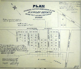
Subdivision of the Hawley Estate in the Township of Murray
Fait partie de Map collection
A certified reproduction of the "Hawley Estate, subdivision being part of Lot # 1 in 1st Concession of Murray Township.” Surveyed by Archibald W. Ponton, P.L.S., and signed September 26, 1882.
This copy was made in 1972 of plan #229, as registered in the Hastings Land Registry Office.
Donated by Walter I. Watson, P. L. S.
Sans titre