Mostrando 5 resultados

Descripción archivística
Elmore, Publius Virgillius, D.P.S. Thurlow, Township of
Imprimir vista previa Hierarchy Ver :

5 resultados con objetos digitales Muestra los resultados con objetos digitales

Map of District of Prince Edward County

  • CA ON00156 M/M420-1076
  • Unidad documental simple
  • 1835
  • Parte deMap collection

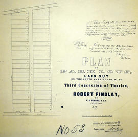
Map showing townships in the District of Prince Edward County: South Murray, Sidney, Thurlow, Ameliasburgh, Sophiasburgh. See boundary lines on map. Surveyed by Publius Virgillius Elmore, D.L.S. Dated 1835. Map copied from the Archives of Ontario.

Sin título

Plan of Meyers Common in the Township of Thurlow

  • CA ON00156 M/M440-1799
  • Unidad documental simple
  • 1850
  • Parte deMap collection

A certified reproduction of the "Plan of Meyers Common - north part of Lot # 5 in 1st Concession of Thurlow Township, now the property of Benjamin Rowe, John Rowe and Burleigh Hunt." It was surveyed in 1848 and refined in 1850 by P. Elmore, P. L. S. “Mill Reserve” on Lots # 9 and 10 on the corner of Mill and Elm Streets and “Bleekers Barn Lot” on Park Street.

This copy was made in 1972 of plan #12, as registered in the Hastings Land Registry Office.

Donated by Walter I. Watson, O.L.S.

Sin título

Subdivision of Lots 5-7 in west Cannifton

  • CA ON00156 M/M430-1901
  • Unidad documental simple
  • c. 1856
  • Parte deMap collection

A certified reproduction of the "Plan shewing subdivisions of Lots # 5, 6 & 7 in 3rd Concession, Thurlow, west side of River Moira, formerly the property of the late Daniel Canniff in 1856." It was redesignated as “West Cannifton" by Jonas Canniff on August 9, 1862. Surveyed by Publius V. Elmore, P. L. S. Certified by John J. Haslett, P.L. S.

This copy was made in 1972 of plan #124, as registered in the Hastings Land Registry Office.

Beyond the bridge over River Moira and northerly are large lots named: 1. Elizabeth A. Ketchepaw; 2. Letty S. Belch; 3. Thomas Canniff; 4. Philean Canniff; 5. Nancy Canniff; 6. Daniel Canniff; 7. Sarah Mormon; 8. Anne Maria Burnes; 9. Catharine Brown.

Sin título

Map of Park and Building Lots Plan in Thurlow

  • CA ON00156 M/M440-1246
  • Unidad documental simple
  • 1863
  • Parte deMap collection

An original map showing a plan for park and building lots on Bleecker Avenue between Concession 2 (College Street) and Bridge Street in Thurlow Township, Ontario. Along with the creation of subdivisions, Meyers Street was also being planned. Drawn by Philip Short for P. V. Elmore, P.L.S. Created on February 9, 1863 and registered 18 days later on February 27. Scale 3.5 chains to an inch.

Property of Tobias Blecker.

Sin título

Plan of park lots on Lot 10 in the Township of Thurlow

  • CA ON00156 M/M430-1738
  • Unidad documental simple
  • Apr 1858
  • Parte deMap collection

A certified reproduction of the Plan of Park Lots on the south part of Lot # 10, in 3rd Concession of Thurlow Township for Robert Findlay. Surveyed by P.V. Elmore, P.L.S. in April of 1858.

This copy was made in 1972 of plan #53, as registered in the Hastings Land Registry Office.

Donated by Walter I. Watson, O.L.S.

Sin título