Mostrando 30 resultados

Descripción archivística
Ransom, John Thomas, P.L.S. Thurlow, Township of
Imprimir vista previa Hierarchy Ver :

29 resultados con objetos digitales Muestra los resultados con objetos digitales

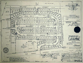
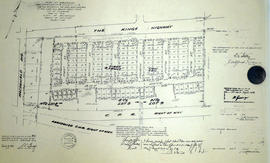
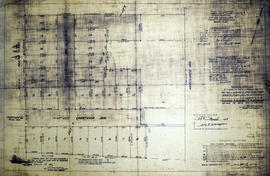
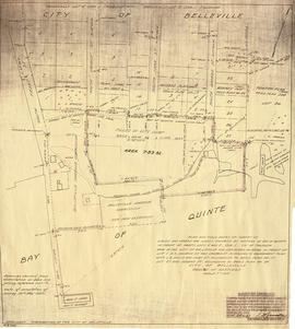
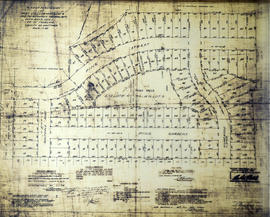
Subdivision of Lots 38, 43, 46 in the City of Belleville

  • CA ON00156 M/M440-2070
  • Unidad documental simple
  • 8 Mar 1947
  • Parte deMap collection

A certified reproduction of the "Subdivision of Lots # 38, 43, and 46 according to registered Plan Memorial No. 358, Murney Block, Belleville.” The area includes; Parker Street North to Charlotte Street East of Wellington Street. Surveyed by John T. Ransom, O. L. S. and signed March 8, 1947.

Donated by Walter I. Watson, P. L. S.

Sin título

Subdivision of part of Lots 5&9 in the Township of Thurlow

  • CA ON00156 M/M440-2076
  • Unidad documental simple
  • 6 Dec 1947
  • Parte deMap collection

A certified reproduction of the "Subdivision of part of the east half of Lot # 5 and west half of Lot # 9, Concession 1, Township of Thurlow , owner Doctor Bertram." The area includes; Bridge Street East north to both sides of Southview Avenue, between east and west halves of Lot # 8 and Lot # 9. Surveyed by John Thomas Ransom, O. L. S. and signed December 6, 1947.

Donated by Walter I. Watson, P. L. S.

Sin título

Subdivision of part of Lots 5-6 in the Township of Thurlow

  • CA ON00156 M/M440-2078
  • Unidad documental simple
  • 23 Nov 1948
  • Parte deMap collection

A certified reproduction of the "Subdivision of part of Lots # 5 and 6, Concession 2, and Lots # 4, 5 and 6 west side James Street of Registered Plan 103, Township of Thurlow." The area includes; Lots # 4, 5, 6 in Concession 2 on both sides of Orchard Drive and North Park Gardens. Surveyed by John Thomas Ransom, O. L. S. and signed November 23, 1948.

Donated by Walter I. Watson, P. L. S.

Sin título

Subdivision of Lots 8-9 in the Township of Thurlow

  • CA ON00156 M/M440-2211
  • Unidad documental simple
  • 7 Jul 1952
  • Parte deMap collection

A certified reproduction of the "Subdivision of part of East half Lot # 8 and part West half Lot # 9 in Concession 1, Township of Thurlow now City of Belleville.” The area includes; east of Stanley Street, Lots # 1, 2, 3 & 4 north of Russell Street and north to Station Street.
Surveyed by John Thomas Ransom, O. L. S. and signed July 7, 1952.

This copy was made in 1972 of plan #890, as registered in the Hastings Land Registry Office.

Donated by Walter I. Watson, P. L. S.

Sin título

Subdivision of Part Lot 12 in the Township of Thurlow

  • CA ON00156 M/M440-2214
  • Unidad documental simple
  • 10 Jan 1955
  • Parte deMap collection

A certified reproduction of the "Plan of Subdivision of Part Lot # 12, Reg. Plan No. 65, Township of Thurlow, owners Donald Brook & Martha E. Brook.” The area surveyed includes; west of Herchimer Avenue and 18 Lots on both sides of Southview Avenue. Surveyed by John T. Ransom, O. L. S. and signed January 10, 1955.

This copy was made in 1972 of plan #980, as registered in the Hastings Land Registry Office.

Donated by Walter I. Watson, P. L. S.

Sin título

Subdivision of part of Lots 4-5 in the Township of Thurlow

  • CA ON00156 M/M440-2231
  • Unidad documental simple
  • 24 Jun 1955
  • Parte deMap collection

A certified reproduction of the "Subdivision of part of Lots # 4 & 5 east of North Park St. Gov't Plan Township of Thurlow. Owners: Arthur J. & Daisy I Bongard.” The area includes; east of North Park Street, being 14 Lots on both sides of Bongard Crescent. Surveyed by John T. Ransom, O. L. S. and signed June 24, 1955.

Donated by Walter I. Watson, P. L. S.

Sin título

Subdivision of part of Lots 3-4 in the Township of Thurlow

  • CA ON00156 M/M440-2247
  • Unidad documental simple
  • 3 Jul 1956
  • Parte deMap collection

A certified reproduction of the "Subdivision of part Lots # 3 and 4, Reg'd Plan 797, Township of Thurlow, prepared for Earl H. and Vera M. Moon.” The area includes; east of Sidney Street, Belleville, and south of Brown Street, being Lots # 1, 2, 4, on the east side of Shamrock Street and Lots # 5, 6, 7, 8 on the west side of Shamrock Street. Surveyed by John T. Ransom, O. L. S. and signed July 3, 1956.

Donated by Walter I. Watson, P. L. S.

Sin título

Subdivision of part of Park Lot 1 in the Township of Thurlow

  • CA ON00156 M/M430-2073
  • Unidad documental simple
  • 18 Mar 1947
  • Parte deMap collection

A certified reproduction of the "Subdivision of part of Park Lot # 1, west of Park Street, being part of Lot # 4, Concession 2, Township of Thurlow." The area includes; north of College Street to Donald Street and west of North Park Street to Madoc Road (North Front Street). Surveyed by John Thomas Ransom, O. L. S. and signed March 18, 1947.

Donated by Walter I. Watson, P. L. S.

Sin título

Subdivision of Park Lot 1 in the Township of Thurlow

  • CA ON00156 M/M440-2107
  • Unidad documental simple
  • 25 Oct 1947
  • Parte deMap collection

A certified reproduction of the "Subdivision of Park Lot # 1, west of Park Street being part of Lot # 4, Concession 2, Township of Thurlow.” The area includes; east Madoc Road to west North Park Street and north from Donald Street to College Street in the south. Surveyed by John Thomas Ransom, O. L. S. and signed October 25, 1947.

Donated by Walter I. Watson, P. L. S.

Sin título

Subdivision of part Lots 8-9 in the Township of Thurlow

  • CA ON00156 M/M440-2114
  • Unidad documental simple
  • 11 Apr 1949
  • Parte deMap collection

A certified reproduction of the "Subdivision [of] part east and west halves of Lot # 8 and west half Lot # 9... First Concession, Township Thurlow.” The total area surveyed includes; King's Highway (Highway 2) north to Bridge Street East. Surveyed by John T. Ransom, O. L. S. and signed April 11, 1949.

This copy was made in 1972 of plan #809, as registered in the Hastings Land Registry Office.

Donated by Walter I. Watson, P. L. S.

Sin título

Subdivision of part Lots 8-9 in the Township of Thurlow

  • CA ON00156 M/M430-2116
  • Unidad documental simple
  • 25 Jul 1949
  • Parte deMap collection

A certified reproduction of the "Subdivision [of] part east and west halves of Lot # 8 and west half Lot # 9... First and Broken Front Concession, Township Thurlow.” The total area surveyed includes; east of MacDonald Avenue and between C. P. R. right of way and the Kings Highway (Highway 2), including both sides of Sixth Street. Surveyed by John T. Ransom, O. L. S. and signed July 25, 1949.

This copy was made in 1972 of plan #812, as registered in the Hastings Land Registry Office.

Donated by Walter I. Watson, P. L. S.

Sin título

Plan of Survey of part Lots 7-8 in the Township of Thurlow

  • CA ON00156 M/M440-2216
  • Unidad documental simple
  • 1 Mar 1955
  • Parte deMap collection

A certified reproduction of the "Plan of Survey of part Lots # 7 & 8, Reg. Plan No. 65, Township of Thurlow.” The area surveyed includes; west of Herchimer Avenue, Lots on both sides of Crestview Avenue and both sides of Rosewood Avenue. Surveyed by John T. Ransom, O. L. S. and signed March 1, 1955.

This copy was made in 1972 of plan #984, as registered in the Hastings Land Registry Office.

Donated by Walter I. Watson, P. L. S.

Sin título

Subdivision of Lots 6-8, 16-18 in the Township of Thurlow

  • CA ON00156 M/M440-2217
  • Unidad documental simple
  • 1 Mar 1955
  • Parte deMap collection

A certified reproduction of the "Plan of Survey of Lots # 6, 7, 17, & 18 and part Lots # 8 & 16. Reg. Plan 217, Township of Thurlow. Owners - M. E. Reid & Lena R. Reid of Woodland Acres Co-Operative Ltd.” The area surveyed includes; land between Bridge Street East, and Victoria Avenue, being west of Farley Avenue. Surveyed by John T. Ransom, O. L. S. and signed March 1, 1955.

This copy was made in 1972 of plan #985, as registered in the Hastings Land Registry Office.

Donated by Walter I. Watson, P. L. S.

Sin título

Re-subdivision of Lots 12-16 in the Township of Thurlow

  • CA ON00156 M/M440-2288
  • Unidad documental simple
  • 9 Oct 1956
  • Parte deMap collection

A certified reproduction of the "Resubdivision of part Reg'd Plan 171, as follows, Lots # 12,13, 14,15 and 16 and parts of 10,11,17 west of Annie Rose Street...Township of Thurlow.” The area includes; south of Maple Drive, both sides of Jackson Avenue and Highview Crescent and Annie Rose Street. Surveyed by John Thomas Ransom, O. L. S. and signed October 9, 1956.

Donated by Walter I. Watson, P. L. S.

Sin título

Map of planned Belleville Harbour

  • CA ON00156 M/M440-3034
  • Unidad documental simple
  • 19 May 1947
  • Parte deMap collection

A map showing a plan for the Belleville Harbour. The total area stretches from south Front Street to the Ponton Plan. Published by John T. Ransom on May 19th, 1947. The map features field notes of survey of lands, marshes and Bay of Quinte waters. Scale: 1':100'.

Sin título

Plan of block in east end of Belleville

  • CA ON00156 M/M440-1301
  • Unidad documental simple
  • 1 Mar 1951-14 Apr. 1960
  • Parte deMap collection

A map showing a plan of survey for lots 4, 5, 6, 7, 8, 9 and lots 37, 38, 39, 40 on the south side of Bridge Street East between Dufferin and Macdonald Avenues in Belleville, Ontario. Surveyed by John T. Ransom on March 1, 1951 and amended April 14, 1960. Scale: 1'':50'.

Sin título

Subdivision of part of Lots 3-7 in the Township of Thurlow

  • CA ON00156 M/M430-2074
  • Unidad documental simple
  • 18 Mar 1947
  • Parte deMap collection

A certified reproduction of the "Subdivision of Lots # 3, 4, 5, 6 and 7 on registered plan 186, and part of Park Lot # 1, east of Park Street, being part of Lot # 4, Concession 2, Township of Thurlow." The area includes; College Street North to Donald Street and between North Park Street and both sides of Reynolds Cresent. Surveyed by John Thomas Ransom, O. L. S. and signed March 18, 1947.

Donated by Walter I. Watson, P. L. S.

Sin título

Subdivision of part of Lots 8-9 in the Township of Thurlow

  • CA ON00156 M/M440-2081
  • Unidad documental simple
  • 20 Sep 1948
  • Parte deMap collection

A certified reproduction of the "Subdivision of part of East half of Lot # 8 and west half of Lot # 9 and road allowance between Concession 1, Township of Thurlow.” The area includes; east Belleville, both sides of Pine Street, of Pine gardens, of Humewood Drive, and of Golfdale Road. Surveyed by John Thomas Ransom, O. L. S. and signed September 20, 1948.

Donated by Walter I. Watson, P. L. S.

Sin título

Subdivision of Lots 13-14 in the Township of Thurlow

  • CA ON00156 M/M440-2108
  • Unidad documental simple
  • 30 Apr 1948
  • Parte deMap collection

A certified reproduction of the "Subdivision of Lot # 13 and part Lots # 12 & 14, east of MacDonald Avenue, Registered Plan 123, Township of Thurlow.” The area includes; east of MacDonald Avenue, north of MacDonald Gardens, both sides of Cherry Gardens, and west of County Farm. Surveyed by John Thomas Ransom, O. L. S. and signed April 30, 1948.

Donated by Walter I. Watson, P. L. S.

Sin título

Subdivision of Lots 5-7 in the Township of Thurlow

  • CA ON00156 M/M440-2119
  • Unidad documental simple
  • 26 Jul 1949
  • Parte deMap collection

A certified reproduction of the "Subdivision [of] Lot # 6 and part Lot # 5 east of North James Street, Lot # 7 and part of Lots # 5 and 6 west of Moira Street according to Reg'd Plan No. 103, Township of Thurlow.” The total area surveyed includes; North James Street (now Prince of Wales Drive) and east to Moira Street East, both sides of Elvins Street and Gardens. Surveyed by John T. Ransom, O. L. S. and signed July 26, 1949.

This copy was made in 1972 of plan #815, as registered in the Hastings Land Registry Office.

Donated by Walter I. Watson, P. L. S.

Sin título

Resultados 1 a 20 de 30