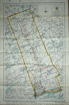
Map of Middle Hastings County 1963
- CA ON00156 M/M420-1117
- Item
- 1963
Part of Map collection
Middle Hastings County in 1963. Map features boundaries, roads and railways. Scale: 1 inch : 1 mile. Published by the Department of Highways, Ontario. Made by Hunting Survey Corp. Ltd.
Features: road jurisdictions, Kings Highways, secondary highways, county roads, township roads, roads legally open but not necessarily passable, urban corporate limits, railways and stations, township boundaries, county boundaries, populated areas.
Ontario. Department of Highways