A map of the Boreal Forest of Canada
A map of the Boreal Forest of Canada
Aerial Photograph of the Lower Trent Region Conservation
Aerial Photograph of the Lower Trent Region Conservation
Map of Hastings County and surrounding area
Map of Hastings County and surrounding area
Map of Lennox and Addington, Frontenac and Prince Edward Counties.
Map of Lennox and Addington, Frontenac and Prince Edward Counties.

Map of Kingston to False Ducks Island

Map of the Moira Region Watershed

Map of Facilities within the Moira River Watershed

Townships of Hastings County with advertisements

Topographical Map of Ontario - Belleville Sheet

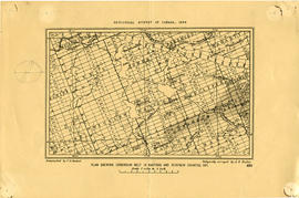
Map Hastings, Prince Edward, Northumberland and Peterborough Counties
Plan showing Corundum Deposits in Hastings County