Forestry in the Townships of Hastings and Prince Edward Counties
- CA ON00156 M/M418-1071
- Item
- 1980
Part of Map collection
Forestry maps of Ameliasburgh, Murray, Rawdon, Sidney and Thurlow townships from 1980.
79 results with digital objects Show results with digital objects
Forestry in the Townships of Hastings and Prince Edward Counties
Part of Map collection
Forestry maps of Ameliasburgh, Murray, Rawdon, Sidney and Thurlow townships from 1980.

Map of District of Prince Edward County
Part of Map collection
Map showing townships in the District of Prince Edward County: South Murray, Sidney, Thurlow, Ameliasburgh, Sophiasburgh. See boundary lines on map. Surveyed by Publius Virgillius Elmore, D.L.S. Dated 1835. Map copied from the Archives of Ontario.
Elmore, Publius Virgillius, D.P.S.

Plan of Hastings for Hastings Directory
Part of Map collection
A map of Hastings County outlining townships:
Marmora, Lake, Madoc, Tudor, Grimsthorpe, Elzevir; Rawdon, Huntingdon, Hungerford, Sidney, Thurlow, Tyendinaga - as well as the northern townships.
Inset is "the Village of Marmora." Surveyed by H. A. F. Macleod, C.E. and P.L.S. Published by W. A. Little Lith., Montreal in the 1864-1865 copy of the Hastings Directory . Scale: 1:190,000.
MacLeod, Henry Augustine Fitzgerald, P.L.S.

Map of Hastings with the Principal Villages and the City of Belleville
Part of Map collection
A map of Hastings County including the Town of Belleville and other principal villages:
Trenton, Madoc, Marmora, Tweed, Bridgewater, Stirling, Wicklow, Bangor, Herschel, Monteagle, Carl, Dungannon, Wollaston, Limerick, Cashel, Tudor, Grimsthorpe, Elzevir; Rawdon, Huntingdon, Hungerford, Sidney, Thurlow, Tyendinaga.
Scale: 3 miles =1 inch. Published by Evans & Bolger, P. L. Surveyors, P.L.S. in 1879-1880.
Evans and Bolger

Map of Hastings County in 4 sections
Part of Map collection
A map of Hastings County outlining townships from the Bay of Quinte in the south, to Wallaston, Limerick and Cashel in the north.
Map is in four sections. Scale: 3 miles : 1 inch. Original map is dated 1894. Photocopy from the Archives of Ontario.

Map of the Counties of Hastings and Prince Edward
Part of Map collection
A "Map of the Counties of Hastings and Prince Edward." In 1898, the lots, concessions, churches, schools and mines are shown of the townships in Hastings and Prince Edward. Scale: 1.5 miles to an inch. Published by the Canadian Map Publishing Company in Hamilton, Ontario, for the Belleville Sun. Revised by Henry Carre, C.E. Inset is the map of North Hastings, scale 400 chains to an inch.
Carre, Henry, O.L.S.

Map of Hastings with townships
Part of Map collection
A map of Hastings County outlining the twelve townships:
Marmora and Lake, Madoc, Tudor, Grimsthorpe, Elzevir; Rawdon, Huntingdon, Hungerford, Sidney, Thurlow, Tyendinaga.
As well as, the lots and concessions. Circa 1916.Scale: 4 miles: 1 inch.
Donated by K.G.M. Ross.

Townships of Hastings County with advertisements
Part of Map collection
A map of Hastings County, in 1932, showing lakes, rivers, cities, towns and townships. A list of businesses within the county are on the right. Drawn exclusively for and published by Croydon Publishing Company.
Croydon Publishing Co.

Map of Southern Hastings County
Part of Map collection
Southern Hastings County in 1963. Map features boundaries, roads and railways. Scale: 1:63,360. Published by the Department of Highways, Ontario. Made by Hunting Survey Corp. Ltd. Dimensions 107.5cm x 92.5cm.
A unique "one-inch" map because all one-inch series maps were converted to 1:50,000 after 1950. However, this map was converted to 1:63,360.
Ontario. Department of Highways

Resources Map of Hastings County
Part of Map collection
Resources map of Hastings County, Ontario, showing agricultural activity and natural resources.

Lloyd's Map of Hastings County
Part of Map collection
A map of Hastings County outlining the twelve townships:
Marmora and Lake, Madoc, Tudor, Grimsthorpe, Elzevir; Rawdon, Huntingdon, Hungerford, Sidney, Thurlow, Tyendinaga. The northern townships are pictured on the right side.
As well as, the lots and concessions. Circa 1922. Scale: 1.5 miles: 1 inch. Published by Lloyd's Maps, Map Publisher.
Lloyd's Map, Map Publisher

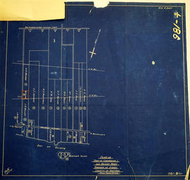
Part of Map collection
A map of Sidney Township, specifically the District of Mecklenburg in 1787. Contains information on the plans for the 1st, 2nd, and 3rd concessions, as well as property owners. Created by Lewis Kotte, Deputy Provincial Surveyor. Scale: 40 chains to an inch.
Kotte, Lewis

Part of Map collection
A map of Sidney Township, the Plan of Lots on Gladstone Avenue/Trent Road, 1912. Published by Lucien & Allen C.E. on January 2nd, 1912. Created by A.W. Ponton, P.L.S. Scale: 100 feet : 1 inch.
Ponton, Archibald William, P.L.S. & D.L.S.
Map of Expropriated Land for Trenton Air Base
Part of Map collection
A map of Sidney Township, part of Concession #1 and Broken Front, October 18th, 1912. The map details a tract of land expropriated for Trenton Air Base. Scale: 12.5 chains : 1 inch.
Attached is a letter dated May 1st, 1931, The King versus Maitland Hutton and Leda Hutton.

Lot Division Map of Sidney Township
Part of Map collection
A lot division map of Sidney Township in Hastings County, Ontario. Published by the Department of Land Surveys on August 18th, 1944. Scale: 1=4,000.
Bottom right corner reads "Dominion of Canada, War Assets Corporation" and discusses a storage yard location on Lot 3, Concession 1.
Department of Land Surveys
Sidney Township Zoning Bylaw Concessions 1&2
Part of Map collection
"Township of Sidney Zoning Bylaw" in concession, B. F. 1 & 2. Dated 2 Feb 1978. Published by the Quinte Planning Board. Composed by M. A. B.
Quinte Planning Board
Sidney Township Zoning Bylaw Concessions 3-5 to 401
Part of Map collection
"Township of Sidney Zoning Bylaw" in concessions 3-5 to Highway 401. Dated 2 Feb 1978. Published by the Quinte Planning Board. Composed by Laura.
Quinte Planning Board
Sidney Township Zoning Bylaw Concessions 6-9
Part of Map collection
"Township of Sidney Zoning Bylaw" in concessions 6-9. Dated 2 Feb 1978. Published by the Quinte Planning Board. Composed by Laura.
Quinte Planning Board
All of Sidney Township Zoning Plans
Part of Map collection
"Sidney Township" maps apart of the zoning bylaws series. Dated 2 Feb 1978. Scale: 1:12,500. Published by the Quinte Planning Board. Composed by Laura.
Quinte Planning Board
Quinte Planning Area - Concept Plan
Part of Map collection
Proposal plan for Quinte area containing Sidney and Thurlow townships. Dated 31 Oct 1978. Scale: as shown. Published by the Quinte Planning Board. Composed by Laura.
Quinte Planning Board