Playing with Fire: Trenton and the British Chemical Company
- CA ON00156 2019-010
- Item
- 2018
Digital film exploring the history of the British Chemical Company's plant in Trenton, Ontario, and the Trenton Explosion of 14 October 1918.
Scally, Sean
19 results directly related Exclude narrower terms
Playing with Fire: Trenton and the British Chemical Company
Digital film exploring the history of the British Chemical Company's plant in Trenton, Ontario, and the Trenton Explosion of 14 October 1918.
Scally, Sean
Part of Map collection
A map of Quinte West, Ontario featuring streets, waterways and significant buildings - see legend for details.
Bay of Quinte Regional Mapping
Trenton, Ontario as colouring sheet
Part of Map collection
A "colour-in" map of Trenton, Ontario (now Quinte West) from 1990.
Reitsma, Peter
Essay on the Gilmours of Trenton
McDonald, Andrew

Many Town Residents Attend 'Open House' at Paper Plant
A newspaper article pertaining to an open house held at the Hinde and Dauch Paper Company plant in Trenton.
Trenton News

Map of Town Plot at mouth of Trent River
Part of Map collection
A map of a town plot at the mouth of the Trent River in the Newcastle District. The map features numbered lots, present streets and water ways. Scale: 1 inch = 2 chains. Originally surveyed by F. P. Rubidge, D.P.S., in 1834. This copy was issued September 23, 1926.
Rubidge, Frederick Preston, D.P.S.
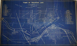
Map of the Town of Trenton 1926
Part of Map collection
A map of the town of Trenton, Ontario in June 1926. The map features numbered lots, present industries, CNR tracks and other important buildings. Streets and their names, as well as the River Trent are also present. Scale: 1:3000. Composed by Mayor W. A. Fraser and published by his Town Council.
Fraser, William Alexander
Trenton industry : British Chemical Works
File contains newspaper clippings and photos concerning the October 14, 1918 explosion of British Chemical Works, which manufactured TNT for the war effort.

Town of Trenton with advertising businesses
Part of Map collection
A photocopy of a map of the Town of Trenton, circa 1915. The map features advertisements for local businesses, important sites, industries and many railways and stations.
Donated by Bruce Polmanter.
Collection of canning company record books
Collection of account books, primarily relating to Hastings County canning companies:
Frankford Canning and Preserving Company Limited
Foxboro Canning Company Limited
Trent Valley Canners Limited
Barr Registers Limited [Trenton]

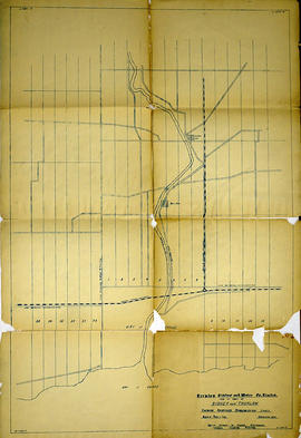
Seymour Power & Electric Co. Limited in Murray Township
Part of Map collection
An original map produced for the Seymour Power & Electric Co. Limited, concerning proposed transmission lines within the Township of Murray. However, the map also features railways, roads, mills and land boundaries. Circa 1910. Scale: 50 chains = 1 inch. Map composed by Smith, Kerry and Chace Engineers located in Toronto, Winnipeg, Calgary and Vancouver.
Donated by David Pershick.
Smith, Kerry and Chace Engineers

Trenton Electric & Water Co. Limited in Sidney Township
Part of Map collection
An original map produced for the Trenton Electric & Water Co. Limited, concerning proposed transmission lines within the Township of Sidney. However, the map also features railways, roads and land boundaries. Circa 1910. Scale: 50 chains = 1 inch. Map composed by Smith, Kerry and Chace Engineers located in Toronto, Winnipeg, Calgary and Vancouver.
Donated by David Pershick.
Smith, Kerry and Chace Engineers

Trenton Electric & Water Co. Limited in Thurlow Township
Part of Map collection
An original map produced for the Trenton Electric & Water Co. Limited, concerning their water mains, towers and substations within the Township of Thurlow. However, the map also features railways, roads and land boundaries. Circa 1910. Scale: 50 chains = 1 inch. Map composed by Smith, Kerry and Chace Engineers located in Toronto, Winnipeg, Calgary and Vancouver.
Donated by David Pershick.
Smith, Kerry and Chace Engineers
Trenton Electric & Water Co. Limited in Thurlow and Sidney Townships
Part of Map collection
An original map produced for the Trenton Electric & Water Co. Limited, concerning proposed transmission lines within the Townships of Thurlow and Sidney. However, the map also features railways, roads, mills and land boundaries. Dated March 31, 1910. Scale: 1/4 mile = 1 inch. Map composed by Smith, Kerry and Chace Engineers located in Toronto, Winnipeg, Calgary and Vancouver.
The map includes the first 4 concessions, Lots 33-38 in Sidney Township and Lots 1-13 in Thurlow Township.
Donated by David Pershick.
Smith, Kerry and Chace Engineers
Trenton industry : history and development
File contains several newspaper articles concerning the industrial development of Trenton from the early 20th century to ca. 1967..
Trenton : miscellaneous news clippings
File contains miscellaneous newspaper clippings and photographs relating to aspects of Trenton's history including education, sports, the construction of CFB Trenton and industrial development.
Trenton : miscellaneous news clippings
File contains miscellaneous newspaper clippings and photographs relating to aspects of Trenton's history including education, sports, the construction of CFB Trenton and industrial development.
Trenton : Inaugural ceremonies, 1880
File contains the July 2, 1880 issue of the Daily Intelligencer which recounts the celebration of Trenton's inauguration as a town on Dominion Day, 1880. Includes a brief account of the growth and development of the community.
File contains a typescript transcript from Smith's Canada, Volume 2, 1851 concerning natural resources and industries at Trent Port, Murray Township, Presqu'isle and various islands in the Bay of Quinte near Belleville.