Industries

Taxonomía

Código

Nota(s) sobre el alcance

Nota(s) sobre el origen

Mostrar nota(s)

Términos jerárquicos

Industries

Términos equivalentes

Industries

Términos asociados

Industries

5 Descripción archivística resultados para Industries

5 resultados directamente relacionados Excluir términos relacionados

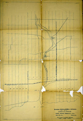
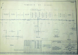
Trenton Electric & Water Co. Limited in Sidney Township

  • CA ON00156 M/M430-2998 - 3001/M430-3001
  • Unidad documental simple
  • c. 1910
  • Parte deMap collection

An original map produced for the Trenton Electric & Water Co. Limited, concerning proposed transmission lines within the Township of Sidney. However, the map also features railways, roads and land boundaries. Circa 1910. Scale: 50 chains = 1 inch. Map composed by Smith, Kerry and Chace Engineers located in Toronto, Winnipeg, Calgary and Vancouver.

Donated by David Pershick.

Sin título

Trenton Electric & Water Co. Limited in Thurlow and Sidney Townships

  • CA ON00156 M/M430-2998 - 3001/M430-2999
  • Unidad documental simple
  • 31 Mar 1910
  • Parte deMap collection

An original map produced for the Trenton Electric & Water Co. Limited, concerning proposed transmission lines within the Townships of Thurlow and Sidney. However, the map also features railways, roads, mills and land boundaries. Dated March 31, 1910. Scale: 1/4 mile = 1 inch. Map composed by Smith, Kerry and Chace Engineers located in Toronto, Winnipeg, Calgary and Vancouver.

The map includes the first 4 concessions, Lots 33-38 in Sidney Township and Lots 1-13 in Thurlow Township.

Donated by David Pershick.

Sin título

Sidney Township, Gas Line Map # RL32532

  • CA ON00156 M/M430-2619
  • Unidad documental simple
  • 1958
  • Parte deMap collection

"Sidney Township, Map # RL32532." A "Plan showing a survey of a Gas Pipe Line Right of Way though Lots # 20 to 29 inclusive, Concession 3, Township of Sidney, County of Hastings." Surveyed in 1958 by Marshall, Macklin & Monaghan, O. L. S Scale: 1 inch = 400 ft.

Donated by Walter I. Watson, P. L. S.

Sin título

Air Surveys of Hastings County, Ontario

  • CA ON00156 M/M470-2622 - 2625
  • Unidad documental simple
  • 1982
  • Parte deMap collection

All air surveys were published in 1982. Scale 1; 10,000. By the Ontario Ministry of Natural Resources, Map base by Survey and Mapping Branch, Air Photography.

1) M470-2622. Rawdon Township Map # 10-18-2900-49050 showing areas of; the South West area of Rawdon Township, Concession 1 & 2 and Marsh Creek Watershed, Anson (Station) on the C. N. R. and part of Sidney Township, Concession 8.

2) M470-2623. Sidney Township, Map # 10-18-2900-49000 showing areas of; the Northwest area of Sidney Township being Trent River and Canal System including Wilson Island, Glen Ross, Richardson Cove, Heagles Island and South to Concession 6, Township of Sidney.

3) M470-2624. Sidney Township, Map # 10-18-2950-49000 showing areas of; Sidney Township, Concession 6, 7 and 8, Lots # 16 to 26, including part of Rawdon Creek, Oak Lake, Stirling Airfield..

4) M470-2625. Stirling, Map # 10-18-2950-4905 showing areas of; the Village of Stirling and surrounding area of Sidney & Rawdon Townships.

Sin título