Belleville – copy of Industrially Yours (2)
- CA ON00156 TR/0566-2
- File
- [1940-1960]
File contains an “Industrially Yours” booklet on why Belleville would be a good place for company's to build factories.
177 results directly related Exclude narrower terms
Belleville – copy of Industrially Yours (2)
File contains an “Industrially Yours” booklet on why Belleville would be a good place for company's to build factories.

Digital copy of photograph of staff of Shannonville Canning Ltd.
Staff of Shannonville Canning Ltd., Shannonville, Ontario, in September 1938.
Names supplied:
Back row: Nellie Howard, Maggie Brant, Maggie Maracle, Mae Hill, Ethel Bardy, Georgina Rupert, Edna Maracle, Beatarice Brant, John Weese, ?, Mac FitzGerald, Lena FitzGerald, Edna Fuller, Harold Burtt, Mavis John, ?, Beatrice Smart, ?, Blanche Hill, Ivan Hill, Cora Maracle, Harold Elmy, Mr. Rightmyer, Tommy Howard and Percy "Diner" Howard
Second row: Marjorie FitzGerald, Dorsey Brant, Josie FitzGerald, Ethel John, Lydia Marion, Winnifred Maracle, Julia Maracle, Lydia Maracle, Kathleen Louis, Sadie Maracle, Gladys Brant, Eva Burtt, Anita Goodfellow, Stella Breadman, ?, Mrs Burtt, Winnie Howard and Marjorie Brant
Third row: Vincent Bardy, Madeline Spencer, ?, Pearl Brant, Leola Brant, Evelyn Noye, Muriel Hill, Alice Dow, Marjorie Elmy, Marion Hill, Reta Conley, Edna McCarthy, Helena Sager, Maggie Hill, Bertha Reed, Flossie ?, and Helen Fuller
Front row: Austin Fuller, Ross Brant, Clifford Hill, Eugene Maracle, Lorne Maracle, Harry Uens, ?, William Hill, ?, Carmon Spencer, Laural Burtt, Gerald Louis, Blake Cook and Roy Sager
Joseph H. Dow. Research by Lois Foster
Research material on Joseph H. Dow. Includes: 83 page book on The Dow Chemical Company from 1983, 5 pages of correspondence between E. N. Brandt and Lois Foster, 2 photocopies, and 113 page book The Papers of Herbert H. Dow: A Guide for the Scholarly by E. N. Brandt and Barbara Schettig Brennan.
Foster, Lois

Part of Map collection
A map of Prince Edward County featuring information about local historical traditions, agriculture, community life and geography. Published in 1937 through Picton Times by Conger Allison. Dimensions: 72cm x 53cm.
Allison, Conger

Map of Canada indicating Natural Resources
Part of Map collection
A "Map of Canada - Exclusive of Northern Regions - Indicating Main Natural Resources." Map revised in 1936. Published by the Department of Mines & Resources (Canada). Scale: 100 miles to 1 inch.
Canada. Department of Energy, Mines and Resources
Belleville Businesses - 1930's Advertising Blotters
Four advertising blotters (cards) from businesses in Belleville, Ontario.
Includes:

Topographical Map of Ontario - Belleville Sheet
Part of Map collection
A map of Hastings, Prince Edward, Northumberland and Peterborough counties in 1929 from the Department of Interior Canada. By J.E. Chalifour, Chief Geographer. Scale: 1" to 3.95 miles.
The legend includes additional information about counties, towns, villages, boundaries, railways, canals, lots, concessions, portages, rapids and First Nations Territories.
Canada. Department of the Interior
Hastings County – Resources & Industry 1929
File contains a report by the National Development Bureau – Department of the Interior about the natural resources and industries in Hastings County,

Map of Town Plot at mouth of Trent River
Part of Map collection
A map of a town plot at the mouth of the Trent River in the Newcastle District. The map features numbered lots, present streets and water ways. Scale: 1 inch = 2 chains. Originally surveyed by F. P. Rubidge, D.P.S., in 1834. This copy was issued September 23, 1926.
Rubidge, Frederick Preston, D.P.S.
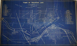
Map of the Town of Trenton 1926
Part of Map collection
A map of the town of Trenton, Ontario in June 1926. The map features numbered lots, present industries, CNR tracks and other important buildings. Streets and their names, as well as the River Trent are also present. Scale: 1:3000. Composed by Mayor W. A. Fraser and published by his Town Council.
Fraser, William Alexander
Belleville Industrial Fair 1925
File contains a c.1925 program from the Belleville International Fairs production of “The Pagaent of Progress”, a John B. Rogers production.
File contains printed letters patent, licensing authority issued by the Province of Ontario, and financial correspondence relating to the Globe Machinery Company, a woodworking firm incorporated in Belleville in 1925.

Photograph of Canada Cement Company Plant No. 5
Photograph of the Canada Cement Company Plant Number Five at Point Anne.
Donoahue, Thomas
Trenton industry : British Chemical Works
File contains newspaper clippings and photos concerning the October 14, 1918 explosion of British Chemical Works, which manufactured TNT for the war effort.

Part of Elliott family collection
File contains printed materials:
Elliott, John
Trenton industry : Public Service Bulletin, 1918
File contains a printed Public Service Bulletin issued by the Province of Ontario, November 1918 which includes brief reports and statistics of various provincial ministries regarding resource exploitation and industries in Ontario. Brief mention is included of the explosion of the British Chemical plant at Trenton.

Map Hastings, Prince Edward, Northumberland and Peterborough Counties
Part of Map collection
A map of Hastings, Prince Edward, Northumberland and Peterborough counties in 1916 from the Department of Interior Canada. Published by J.E. Chalifour, Chief Geographer. Scale: 3" to 95 miles. Dimensions 63.5cm x 96.5cm.
The legend includes additional information about counties, towns, villages, boundaries, railways, canals, lots, concessions, portages, rapids and First Nations Territories.
Canada. Department of the Interior
File contains a 1969 article about R. J Graham and how the best “evaporating system” is in Belleville.

Share certificate for Springer Lock Manufacturing Company
Certificate for one share of $100 of the capital stock of the Springer Lock Manufacturing Company Limited, issued to C. A. Campbell on 24 November 1915. Signed by W. C. Springer, Managing Director, A. J. Bird, Secretary-Treasurer, and Mackenzie Bowell, President.
Springer Lock Manufacturing Company

Town of Trenton with advertising businesses
Part of Map collection
A photocopy of a map of the Town of Trenton, circa 1915. The map features advertisements for local businesses, important sites, industries and many railways and stations.
Donated by Bruce Polmanter.