- CA ON00156 TR/0269
- File
- 1916
File contains a 1969 article about R. J Graham and how the best “evaporating system” is in Belleville.
161 results directly related Exclude narrower terms
File contains a 1969 article about R. J Graham and how the best “evaporating system” is in Belleville.

Rawdon Township : History of Springbrook
File contains a handwritten essay by Florence McKeown and Ida Smith both from Springbrook regarding the history of Springbrook community ca. 1838 to 1965. Includes information on roads, local industry, churches, schools and a brief account of the cheese factories and local families
Northern Telecom publicity materials
Promotional materials written by Ron Truman for Northern Telecom:
1) CompQuote (Montreal) Displayphone case study flyer
2) Slater Steels (Hamilton) Displayphone case study flyer
3) Health Care Telecommunications Meridian SL-1 flyer
4) The Canada Council Meridian SL-1 Application Report flyer
5) Meridian Report, Volume 1, Issue 1, December 1986
Nortel Networks

Digital copies of photographs relating to the lumber industry in Hastings County
Photographs of lumber camps and First World War infantry units in the Marmora area of Hastings County, Ontario.

Map of Mineral Deposits in Coehill and Jenkins
Part of Map collection
"Coehill and Jenkins Irone Ore Deposits, Lots 15, 16, 17, 18, Concession 8, Township of Wollaston, Hastings County, Ontario."
A map published by the Department of Mines of Canada, in 1911, showing contour lines, magnetic intensities and other physical features. Surveyed by E. Lindeman.
Donated by Nick January in 2016.
Canada. Department of Mines and Technical Surveys
Scrapbook on the history of Hastings County, Moira Valley.
This file contains a scrapbook created by Bruce Dobbs on the history of Hastings County, Moira Valley. Articles from the Intelligencer.

Map of Canada indicating Natural Resources
Part of Map collection
A "Map of Canada - Exclusive of Northern Regions - Indicating Main Natural Resources." Map revised in 1936. Published by the Department of Mines & Resources (Canada). Scale: 100 miles to 1 inch.
Canada. Department of Energy, Mines and Resources
Photographs of Graham Food Products Ltd.
Six black and white photographs of operations inside the Graham Food Products plant in Belleville, Ontario, taken by Rapid, Grip and Batten. Includes an image of Roy Lucas, manager.
Rapid, Grip and Batten

Topographical Map of Ontario - Belleville Sheet
Part of Map collection
A map of Hastings, Prince Edward, Northumberland and Peterborough counties in 1929 from the Department of Interior Canada. By J.E. Chalifour, Chief Geographer. Scale: 1" to 3.95 miles.
The legend includes additional information about counties, towns, villages, boundaries, railways, canals, lots, concessions, portages, rapids and First Nations Territories.
Canada. Department of the Interior
Trenton, Ontario as colouring sheet
Part of Map collection
A "colour-in" map of Trenton, Ontario (now Quinte West) from 1990.
Reitsma, Peter
Map of Belleville - The Friendly City
Part of Map collection
A map of the Belleville featuring details about its history. Published by City Print International in 1991.
Campbell, Neil
Street Plan of the City of Belleville 1982
Part of Map collection
A map showing street plans within the City of Belleville. The map was copyrighted 1982 and published by the Belleville Chamber of Commerce.
Belleville Chamber of Commerce
Records of Stephens-Adamson plant in Belleville
Records created and accumulated by employees of the Stephens-Adamson manufacturing plant in Belleville, Ontario. Materials include printed catalogues, plans, an order book, photographs, and printed ephemera.
Stephens-Adamson Manufacturing Company, Belleville

Map of Town Plot at mouth of Trent River
Part of Map collection
A map of a town plot at the mouth of the Trent River in the Newcastle District. The map features numbered lots, present streets and water ways. Scale: 1 inch = 2 chains. Originally surveyed by F. P. Rubidge, D.P.S., in 1834. This copy was issued September 23, 1926.
Rubidge, Frederick Preston, D.P.S.
Ontario Aerial photographs 1972-1977
Part of Map collection
Aerial photographs showing various townships within Ontario in the 1970s.

Trenton Electric & Water Co. Limited in Sidney Township
Part of Map collection
An original map produced for the Trenton Electric & Water Co. Limited, concerning proposed transmission lines within the Township of Sidney. However, the map also features railways, roads and land boundaries. Circa 1910. Scale: 50 chains = 1 inch. Map composed by Smith, Kerry and Chace Engineers located in Toronto, Winnipeg, Calgary and Vancouver.
Donated by David Pershick.
Smith, Kerry and Chace Engineers

Seymour Power & Electric Co. Limited in Murray Township
Part of Map collection
An original map produced for the Seymour Power & Electric Co. Limited, concerning proposed transmission lines within the Township of Murray. However, the map also features railways, roads, mills and land boundaries. Circa 1910. Scale: 50 chains = 1 inch. Map composed by Smith, Kerry and Chace Engineers located in Toronto, Winnipeg, Calgary and Vancouver.
Donated by David Pershick.
Smith, Kerry and Chace Engineers
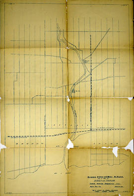
Trenton Electric & Water Co. Limited in Thurlow and Sidney Townships
Part of Map collection
An original map produced for the Trenton Electric & Water Co. Limited, concerning proposed transmission lines within the Townships of Thurlow and Sidney. However, the map also features railways, roads, mills and land boundaries. Dated March 31, 1910. Scale: 1/4 mile = 1 inch. Map composed by Smith, Kerry and Chace Engineers located in Toronto, Winnipeg, Calgary and Vancouver.
The map includes the first 4 concessions, Lots 33-38 in Sidney Township and Lots 1-13 in Thurlow Township.
Donated by David Pershick.
Smith, Kerry and Chace Engineers

Trenton Electric & Water Co. Limited in Thurlow Township
Part of Map collection
An original map produced for the Trenton Electric & Water Co. Limited, concerning their water mains, towers and substations within the Township of Thurlow. However, the map also features railways, roads and land boundaries. Circa 1910. Scale: 50 chains = 1 inch. Map composed by Smith, Kerry and Chace Engineers located in Toronto, Winnipeg, Calgary and Vancouver.
Donated by David Pershick.
Smith, Kerry and Chace Engineers

Town of Trenton with advertising businesses
Part of Map collection
A photocopy of a map of the Town of Trenton, circa 1915. The map features advertisements for local businesses, important sites, industries and many railways and stations.
Donated by Bruce Polmanter.