Wood, John - Huntingdon Twsp. Family History
- CA ON00156 TR/3204
- Item
- 1832-1945
File contains a brief family history commencing with John Wood abt. 1832 until William John Wood 1943.
63 results directly related Exclude narrower terms
Wood, John - Huntingdon Twsp. Family History
File contains a brief family history commencing with John Wood abt. 1832 until William John Wood 1943.
Wills - List of - 1845-1880 See Books A.B.C. in Steel Cabinet
List of people who wrote a will and that the archives has a copy of. 28 pages.
File contains a copy of the transcript of White Lake Pioneer Cemetery (located adjacent to Hwy #62, Concession 10, Huntingdon Twp), compiled through the Madoc Heritage House Experience '81 Program. It contains a full list of internments.
West Huntingdon Wesleyan Methodist Trustee Board account book
Account book registering receipts and expenditures of the Wesleyan Methodist (later United) Church in West Huntingdon, Ontario.
West Huntingdon United Church
West Huntingdon Orange Lodge 1960
File contains a newspaper clipping about the West Huntingdon Orange Lodge electing officers in 1960.

Subdivision of Lots 12-13 in the Township of Huntingdon
Part of Map collection
A certified reproduction of the "Subdivision of part Lots # 12 & 13, Concession XIII, Township of Huntingdon.” The area includes; north shore of Moira Lake, and east of County Road No. 1. Surveyed by John Thomas Ransom, O. L. S. and signed March 13, 1957.
Donated by Walter I. Watson, P. L. S.
Ransom, John Thomas, P.L.S.

Subdivision of Lots 11-12 in the Township of Huntingdon
Part of Map collection
A certified reproduction of the "Subdivision of part Lots # 11 & 12, Concession 13, Township of Huntingdon.” The area includes; Moira Lake, old County Road Hwy 62 and proposed new bridge. Surveyed by John Thomas Ransom, O. L. S. and signed November 10, 1960.
Donated by Walter I. Watson, P. L. S.
Ransom, John Thomas, P.L.S.

South and Central Hastings Map
Part of Map collection
"Cummins Rural Directory Map:" A map of South and Central Hastings, in 1923, featuring post offices, hamlets and lot owners. Map is surrounded by advertisements. Published by Cummins Map Co., Toronto. Dimensions 71cm x 50.5cm.
Cummins Map Company
Sarles, Thomas Day Book 1857-73
File contains bill book belonging to Thomas Sarles from 1857-1873, also obituary for his son Frank Sarles died 12 August 1968
Rebellion Losses Claim #96 : Edward Lloyds, Huntingdon
File contains a manuscript claim submitted to the Provincial Government in 1845 by Edward Lloyds for time served under Capt. William Robertson and for transporting prisoners from Belleville in January, 1838.
Rebellion Losses Claim #95 : Henry Alicumbrack, Huntingdon
File contains a manuscript letter from Henry Alicumbrack to the " Committee...to..examine losses sustained...in Canada in 1838", dated December 27, 1845, for damages arising from alleged “false arrest” and trial in 1838
Rebellion Losses Claim #78 & 115 : John Squires, Huntingdon
File contains a manuscript claim submitted to the Provincial Government by John S. Squire ca. 1845 for time and wages lost as a schoolteacher when serving on militia duty during the Rebellion of 1837.
Rebellion Losses Claim #116 : Andew Snider, Huntingdon
File contains a manuscript claim submitted to the Provincial Government by Andrew B. Snider in 1845 for duties served during the Rebellion at the Trent, and for reimbursement for having his cattle tended to in his absence.
Rebellion Losses Claim #114 : Ebenezer Squires, Huntingdon
File contains a manuscript claim submitted to the Provincial Government by Ebenezer Squires ca. 1845 for the “keeping of...horses” during 1837.
Rebellion Losses Claim #113 : Edward Squires, Huntingdon
File contains a manuscript claim submitted to the Provincial Government by Edward Squires ca. 1845 for duties served in Belleville and Kingston during the Rebellion.

Quaker Cemetery Huntingdon (Moira) Baker Family
This file contains 4 clippings pertaining to the Quaker Cemetery located in Moira.
Plan of South Hastings in the Township of Huntingdon
Part of Map collection
A certified reproduction of the Plan of South Hastings laid out on Lot # 12, 14th Concession of Huntingdon, for Charles. Kirk. Surveyed by C. F. Ayslworth Sr., P.L.S. and signed March 27, 1867.
This copy was made in 1972 of plan #118, as registered in the Hastings Land Registry Office.
Donated by Walter I. Watson, O.L.S.
Aylsworth, Charles Fraser Sr., P.L.S.

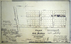
Plan of Rollins Block in the Township of Madock
Part of Map collection
A certified reproduction of the "Rollins Block - Lots on part of Lot # 1 in Concession 5, Township of 'Madock' for proprietor Samuel Rollins.” Rollins Block is between Lot # 2 in 5th Concession of 'Madock', the road between Huntingdon & 'Madock' Township, Francis Street and lastly the road between 5th and 6th Concession of 'Madock.' Surveyed by John Emerson, P.L.S ., and signed October 3, 1875.
This copy was made in 1972 of plan #193, as registered in the Hastings Land Registry Office.
Donated by Walter I. Watson, P. L. S.
Emerson, John, P.L.S.

Plan of Hastings for Hastings Directory
Part of Map collection
A map of Hastings County outlining townships:
Marmora, Lake, Madoc, Tudor, Grimsthorpe, Elzevir; Rawdon, Huntingdon, Hungerford, Sidney, Thurlow, Tyendinaga - as well as the northern townships.
Inset is "the Village of Marmora." Surveyed by H. A. F. Macleod, C.E. and P.L.S. Published by W. A. Little Lith., Montreal in the 1864-1865 copy of the Hastings Directory . Scale: 1:190,000.
MacLeod, Henry Augustine Fitzgerald, P.L.S.
Moira Cemetery, Huntingdon Township, 1958
File contains a newspaper article dated 2 October 1958 concerning the pioneer burial grounds at the Moira Cemetery in Huntingdon Township.