Hungerford Directory list 1860-1861
- CA ON00156 TR/1630
- File
- 1860-1861
File contains a photocopy of the 1860-61 Hungerford Directory list.
62 results directly related Exclude narrower terms
Hungerford Directory list 1860-1861
File contains a photocopy of the 1860-61 Hungerford Directory list.
Hungerford Reeve & Deputy 1860
File contains a signed declaration for the Deputy Reeve and a Certificate of Reeve from 1860 for the township of Hungerford.
Hungerford Stoco Fair proclamation 1860
File contains a proclamation announcing the Village of Stoco will have a Fair or Mart twice a year, in May and October, starting in 1860. The proclamation was forwarded from the office of Sheriff J.W. Dunbar Moodie.
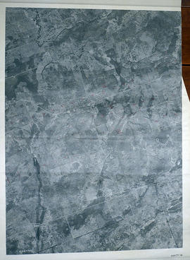
Hungerford Township Map # 444771W
Part of Map collection
A reproduction of an air survey photograph produced by the Ontario Ministry of Natural Resources. Map # 444771W of Hungerford Township in Hastings County, Ontario. Circa 1950.
The photograph shows Hungerford Township from Tyedinaga Township north to Bogart and Claire River.
Donated by Walter I. Watson, P.L.S.
Ontario. Ministry of Natural Resources and Forestry

Hungerford Township Map # 444772E
Part of Map collection
A reproduction of an air survey photograph produced by the Ontario Ministry of Natural Resources. Map #444772E of Hungerford Township in Hastings County, Ontario. Circa 1950.
The photograph shows Hungerford Township, Concession 3 to Tweed Village, Stoco Lake and Bogart Village.
Donated by Walter I. Watson, P.L.S.
Ontario. Ministry of Natural Resources and Forestry

Hungerford Township Map # 445772E
Part of Map collection
A reproduction of an air survey photograph produced by the Ontario Ministry of Natural Resources. Map #445772E of Hungerford Township in Hastings County, Ontario. Circa 1950.
The photograph shows the northeast part of Hungerford Township, south of Elzevir Township, Hwy 7 and Skootamata River.
Donated by Walter I. Watson, P.L.S.
Ontario. Ministry of Natural Resources and Forestry

Hungerford Township Map # 445772W
Part of Map collection
A reproduction of an air survey photograph produced by the Ontario Ministry of Natural Resources. Map #445772W of Hungerford Township in Hastings County, Ontario. Circa 1950.
The photograph shows the east part of Hungerford, southeast corner of Elzevir, west part of Sheffield and southwest part of Kaladar Townships in Lennox and Addington County.
Donated by Walter I. Watson, P.L.S.
Ontario. Ministry of Natural Resources and Forestry
Hungerford Township place names
File contains a list of place names in Hungerford and their history. There is also a copy of a statement made by a surveyor in 1797 regarding the quality of land in Hungerford. Used by Gerry Boyce for his book , Historic Hastings.
The file contains original minute book for the annual school meetings in Moneymore, Hungerford Twp. from 1927 - 1945.
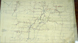
Hydro-Electric Power Commission of Ontario, Tweed Section
Part of Map collection
An original map produced for the Hydro-Electric Power Commission of Ontario, concerning hydro power lines, stations and transformers. However, the map also features railways, roads and land boundaries.
This map is of the Southwest Section - Tweed Rural Power District. The total area includes parts of Hungerford, Huntingdon, and Thurlow Townships. Dated October 16, 1951. Scale: 2 inches = 1 mile.
Donated by David Pershik.
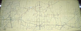
Hydro-Electric Power Commission of Ontario, Tweed-Section
Part of Map collection
An original map produced for the Hydro-Electric Power Commission of Ontario, concerning hydro power lines, stations and transformers. However, the map also features railways, roads and land boundaries.
This map is the West Centre Section - Tweed ROA. The total area includes parts of Rawdon, Marmora, Huntingdon, Madoc, Hungerford, and Elzevir Townships. Dated October 16, 1951. Scale: 1.2 inches = 1 m.
Donated by David Pershik.
Land Records - Gardiner of Hungerford and Murney of Belleville
The file contains:

Lloyd's Map of Hastings County
Part of Map collection
A map of Hastings County outlining the twelve townships:
Marmora and Lake, Madoc, Tudor, Grimsthorpe, Elzevir; Rawdon, Huntingdon, Hungerford, Sidney, Thurlow, Tyendinaga. The northern townships are pictured on the right side.
As well as, the lots and concessions. Circa 1922. Scale: 1.5 miles: 1 inch. Published by Lloyd's Maps, Map Publisher.
Lloyd's Map, Map Publisher
Large account book for unknown lumber merchant, dating from 1843 to 1850
Manuscripts of C.M.E. Johnston
File contains manuscripts written by Cecil Herbert Edward Johnston in 1974 about his family's history and ancestry.

Map of Hastings and Prince Edward Counties
Part of Map collection
A map showing the roads, forts and inns of Hastings and Prince Edward Counties in 1850, by Major Baron DeRottenburg. The map extends from Brighton to Gananoque, Prince Edward County. and North to include Rawdon, Huntingdon, Hungerford Townships of Hastings County. Scale: 2 miles = 1". Dimensions 63cm x 44cm.
DeRottenburg, Major Baron

Map of Hastings County in 4 sections
Part of Map collection
A map of Hastings County outlining townships from the Bay of Quinte in the south, to Wallaston, Limerick and Cashel in the north.
Map is in four sections. Scale: 3 miles : 1 inch. Original map is dated 1894. Photocopy from the Archives of Ontario.

Map of Hastings with the Principal Villages and the City of Belleville
Part of Map collection
A map of Hastings County including the Town of Belleville and other principal villages:
Trenton, Madoc, Marmora, Tweed, Bridgewater, Stirling, Wicklow, Bangor, Herschel, Monteagle, Carl, Dungannon, Wollaston, Limerick, Cashel, Tudor, Grimsthorpe, Elzevir; Rawdon, Huntingdon, Hungerford, Sidney, Thurlow, Tyendinaga.
Scale: 3 miles =1 inch. Published by Evans & Bolger, P. L. Surveyors, P.L.S. in 1879-1880.
Evans and Bolger

Map of Hastings with townships
Part of Map collection
A map of Hastings County outlining the twelve townships:
Marmora and Lake, Madoc, Tudor, Grimsthorpe, Elzevir; Rawdon, Huntingdon, Hungerford, Sidney, Thurlow, Tyendinaga.
As well as, the lots and concessions. Circa 1916.Scale: 4 miles: 1 inch.
Donated by K.G.M. Ross.

Map of Southern Hastings County
Part of Map collection
Southern Hastings County in 1963. Map features boundaries, roads and railways. Scale: 1:63,360. Published by the Department of Highways, Ontario. Made by Hunting Survey Corp. Ltd. Dimensions 107.5cm x 92.5cm.
A unique "one-inch" map because all one-inch series maps were converted to 1:50,000 after 1950. However, this map was converted to 1:63,360.
Ontario. Department of Highways