Hastings Highlands, Municipality of

Taxonomy

Code

Scope note(s)

Display note(s)

Hierarchical terms

Hastings Highlands, Municipality of

Hastings Highlands, Municipality of

Equivalent terms

Hastings Highlands, Municipality of

Associated terms

Hastings Highlands, Municipality of

35 Archival description results for Hastings Highlands, Municipality of

35 results directly related Exclude narrower terms

Election Canada Districts in Monteagle Township

  • CA ON00156 M/M480-2646 - 2652 and 2654/2648
  • Item
  • 2003
  • Part of Map collection

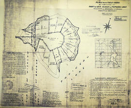
2 photocopies of maps detailing electoral districts #1, 2, 5, 8, 10, 19 within Monteagle Township, Hastings County. The map includes polling divisions, road networks and municipal boundaries. Polling Division # 9 and 9(1). Federal No. 35073.

Canada. Department of Natural Resources

Subdivision of Lot 1 in the Township of Wicklow

A certified reproduction of the "Subdivision of Lot # 1, Concession 10 & 11, Township of Wicklow, for Dept. Lands & Forests.” The area includes; Lots # 1 to 5 and Block 'A' on the northeast shore of Papineau Lake in Wicklow Township. Surveyed by Michael J. McAlpine, O. L. S. and signed December 1, 1960.

Donated by Walter I. Watson, P. L. S.

McAlpine, Michael Joseph, O.L.S.

Subdivision of part of Lot 3 in the Township of Wicklow

A certified reproduction of the "Subdivision of part of Lot # 3, Concession 10, Township of Wicklow, prepared for Dept. of Lands & Forests.” The area includes; Lots # 1 to 12, Blocks A to D on the northwest shore of Papineau Lake. Surveyed by Michael J. McAlpine, O. L. S. and signed December 1, 1960.

Donated by Walter I. Watson, P. L. S.

McAlpine, Michael Joseph, O.L.S.

Subdivision of part of Big Island on Papineau Lake

A certified reproduction of the "Subdivision of part of Big Island in Papineau Lake, Township of Bangor & Wicklow - for Dept. Lands & Forests.” The area includes; Big Island in Papineau Lake, Lots # 1-8 and Blocks P-I in the Township of Bangor & Wicklow. Surveyed by John Thomas Ransom, O. L. S. and signed December 1, 1960.

Donated by Walter I. Watson, P. L. S.

Ransom, John Thomas, P.L.S.

Subdivision of part of Lots 1-2 in the Township of Wicklow

A certified reproduction of the "Subdivision of part of Lot # 1, Concession XI, part of Lot # 2, Concession XII, Township of Wicklow, prepared for Dept. Lands & Forests.” The area includes; Lots # 1 to 11, Lots # 1A, 2A, 3A, 4A, on the northeast shore of Papineau Lake. Surveyed by M. J. McAlpine, O. L. S. and signed June 3, 1960.

Donated by Walter I. Watson, P. L. S.

McAlpine, Michael Joseph, O.L.S.

Subdivision of part of Lots 3-4 in the Township of Wicklow

A certified reproduction of the "Subdivision of parts of Lots # 3 & 4, Concession XII, Township of Wicklow, prepared for Dept. Lands and Forests.” The area includes; Bark Lake, and the subdivision at the south end of Harris Bay, Township of Wicklow. Surveyed by M.J. McAlpine, O. L. S. and signed December 24, 1959.

Donated by Walter I. Watson, P. L. S.

McAlpine, Michael Joseph, O.L.S.

Subdivision of part of Lot 25 in the Township of Bangor

A certified reproduction of the "Subdivision of part of Lot # 25, Concession VIII, Township of Bangor, prepared for Dept. Lands & Forests.” The area includes; Lots # 1 to 7, Lot # 1A and Road Allowance southwest shore of Kaminiskeg Lake. Surveyed by M.J. McAlpine, O. L. S. and signed December 24, 1959.

Donated by Walter I. Watson, P. L. S.

McAlpine, Michael Joseph, O.L.S.

Subdivision of part of Lot 29 in the Township of Bangor

A certified reproduction of the "Subdivision of part of Lot # 29, Concession XI, Township of Bangor, for Dept. Lands & Forests.” The area includes; Lots # 1 to 6 and Block A on the east shore of Kamaniskeg Lake, being part of Lot # 29, Concession XI, Township of Bangor. Surveyed by M.J. McAlpine, O. L. S. and signed March 27, 1962.

Donated by Walter I. Watson, P. L. S.

McAlpine, Michael Joseph, O.L.S.

Subdivision of part of Lot 26 in the Township of Bangor

A certified reproduction of the "Subdivision of part of Lot # 26, Concession XII, Township of Bangor, for Dept. Lands & Forests.” The area includes; Lot # 1 to 8 and Block A on the northeast shore of Kamaniskeg Lake, being part of Lot # 26, Concession XII of Bangor Township. Surveyed by M.J. McAlpine, O. L. S. and signed March 23, 1963.

Donated by Walter I. Watson, P. L. S.

McAlpine, Michael Joseph, O.L.S.

Subdivision of parts of Lots 27-28 in the Township of Wicklow

A certified reproduction of the "Subdivision of part of Lots # 27 and 28, Concession 3 Township of Wicklow prepared for Dept. Lands & Forests.” The area includes; Lots # 1 to 14, Lots # 11A & 12A and Blocks B to F on the southwest shore of Cardwell Lake and Cardwell Lake Road, being part of Lots # 27 & 28 Concession 3, Township of Wicklow. Surveyed by M.J. McAlpine, O. L. S. and signed March 23, 1962.

Donated by Walter I. Watson, P. L. S.

McAlpine, Michael Joseph, O.L.S.

Subdivision of part of Lot 12 in the Township of Wicklow

A certified reproduction of the "Subdivision of part of Lot # 12, Concession VIII, Township of Wicklow, laid out for Dept. Lands & Forests.” The area includes; Lots # 1 to 5 and Block A on the southwest shore of Little Papineau Lake, Wicklow Township, part Lot # 12, Concession VIII. Surveyed by M.J. McAlpine, O. L. S. and signed December 30, 1963.

Donated by Walter I. Watson, P. L. S.

McAlpine, Michael Joseph, O.L.S.

Subdivision of part of Lot 4 in the Township of Bangor

A certified reproduction of the "Subdivision- Part of Lot # 4, Concession VI, Township of Bangor, prepared for Dept. Lands & Forests.” The area includes; Lots # 1, 2, 3 and Lots # 1A & 2A on the southeast shore of Papineau Lake, being Lot # 4, Concession VI, Township of Bangor. Surveyed by M.J. McAlpine, O. L. S. and signed December 31, 1963.

Donated by Walter I. Watson, P. L. S.

McAlpine, Michael Joseph, O.L.S.

Registrar's Plan of Lots 33 & 34 in the Township of Herschel

A certified reproduction of the "Registrar's Compiled Plan, being a graphic index of part Lots # 33 & 34, Concession 3, Township of Herschel.” The area includes; Western border of Hershel Township Lots # 33 & 34, Concession 3, being along the North Westerly shore of Diamond Lake. Surveyed by H. Curry Bishop, O. L. S. and signed January 3, 1970.

Donated by Walter I. Watson, P. L. S.

Bishop, Harry Curry, O.L.S.

Subdivision of part of Lots #17-19 in the Township of Tudor

A certified reproduction of the "Subdivision of part of Lots # 17, 18, 19, Concession 14, Part of Lot # 18, Concession 13 Township of Tudor, owner Jordon Lake Developments Ltd.” The area includes; Jordon Lake, Tudor Township, Lots # 1 to 22 and Block A and B and Streets: North Jordon Lake Road & South Jordon Lake Road being West of Hwy. 62. Surveyed by Edward C. Carter, O. L. S. and signed February 25, 1969.

Donated by Walter I. Watson, P. L. S.

Carter, Edward Christian, O.L.S.

Subdivision of Part of Lots 28 in the Township of Bangor

A certified reproduction of the "Subdivision part of Lot # 28, Concession 7, Township of Bangor, Laid out for Dept. Lands and Forests.” The area includes; Lots # 1 to 6 along the douth shore of Kamaniskeg Lake being on Lot # 28, Concession 7, Bangor Township. Surveyed by Grange W. Elliott, O.L.S. and signed October 13, 1966.

Donated by Walter I. Watson, P. L. S.

Elliott, Grange W., O.L.S.

Subdivision of island opposite Lot 24 in the Township of Cashel

A certified reproduction of the "Subdivision of island opposite Lot # 24, Concession IV, Township of Cashel, over High Pine Developments.” The area includes; Gunter Lake island Lots # 1 to 16 and Block A-B being opposite of Lot # 24, Concession IV, Township of Cashel. Surveyed by David M. Bews, O. L. S. (of McAlpine & Bews, O. L. S.) and signed July 13, 1966.

Donated by Walter I. Watson, P. L. S.

Bews, David Matthew, O.L.S.

Subdivision of Part of Lots 25-26 in the Township of Bangor

A certified reproduction of the "Subdivision of Part of Lots # 25 & 26, Concession XII, Township of Bangor. Prepared for Dept. Lands & Forests.” The area includes; north shore of Kamianiskeg Lake, being Lots # 25 & 26, Concession XII and Lots # 1 to 18 on both sides of road allowance between Lots # 25 & 26, Concession XII. Surveyed by M.J. McAlpine, O. L. S. and signed December 7, 1965.

Donated by Walter I. Watson, P. L. S.

McAlpine, Michael Joseph, O.L.S.

Subdivision of Part of Lot 29 in the Township of Bangor

A certified reproduction of the "Subdivision of Part of Lot # 29, Concession XI, Township of Bangor, prepared for Dept. Lands & Forests, Lands & Surveys Branch.” The area includes; the east shore of Kaminiskeg Lake, Lot # 29, Concession XI, Bangor Township. Surveyed by M.J. McAlpine, O. L. S. and signed December 6, 1965.

Donated by Walter I. Watson, P. L. S.

McAlpine, Michael Joseph, O.L.S.

Subdivision of Part of Lot 26 in the Township of Herschel

A certified reproduction of the "Subdivision of part of Lot # 26, Concession VII, and part of Lots # 26, 27, 28, Concession VIII, Township of Herschel, Prepared for Dept. Lands & Forests.” The area includes; Lots # 1 to 17 on Hay Bay south shore, being Lot # 26, Concession VII & Lots # 26, 27 & 28, Concession VIII, Township of Herschel. Surveyed by H. Curry Bishop, O. L. S. and signed June 1, 1966.

Donated by Walter I. Watson, P. L. S.

Bishop, Harry Curry, O.L.S.

Subdivision of Part of Lots 28-29 in the Township of Cashel

A certified reproduction of the "Subdivision of part of Lots # 28 & 29, Concession IX, Township of Cashel.” The area includes; Lots # 13 to 20 on the northwest shore of Mephisto Lake on Lots # 28 & 29, Concession IX, Township of Cashel. Surveyed by N. H. Verhoef, O. L. S. and signed December 10, 1969.

Donated by Walter I. Watson, P. L. S.

Verhoef, N.H., O.L.S.

Results 1 to 20 of 35