Hastings, County of

Taxonomía

Código

Nota(s) sobre el alcance

Nota(s) sobre el origen

Mostrar nota(s)

Términos jerárquicos

Hastings, County of

Término General Ontario

Hastings, County of

Términos equivalentes

Hastings, County of

Términos asociados

Hastings, County of

5584 Descripción archivística resultados para Hastings, County of

1100 resultados directamente relacionados Excluir términos relacionados

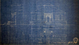
Layout of Buildings at County Court House

  • CA ON00156 M/M450-2851
  • Unidad documental simple
  • 16 Oct 1927
  • Parte deMap collection

A General Layout of the Buildings at the Hastings County Court House on Pinnacle Street in Belleville, Ontario. All buildings are named. Composed by Charles D. Campbell, O.L.S, and dated October 16, 1927.

Donated by Heritage Belleville in 2017.

Sin título

First Floor Plan at County Court House

  • CA ON00156 M/M450-2852
  • Unidad documental simple
  • 15 Nov 1944
  • Parte deMap collection

A Floor Plan of the Main First Floor at the County Court House on Pinnacle Street in Belleville, Ontario. All rooms and areas are named: Turnkey's Apartment, Sheriff's Offices, Judge Cameron's Office, Jail Govenor's Office etc. Composed by Charles A. Mott, City Engineer, and dated November 15, 1944.

Donated by Heritage Belleville in 2017.

Sin título

Plan of Elevations on Ponton Home in Belleville

  • CA ON00156 M/M450-2857
  • Unidad documental simple
  • 11 Jun 1941
  • Parte deMap collection

A blueprint plan of the front and side elevations of the Veranda at the Ponton Home on west Dundas Street (Highway 2). Over the door "Quinte Cottage" is written. Drawn by John Arnold Thomson, Architect, and signed June 11, 1941. The house is now demolished.

Donated by the Heritage Belleville Committee in 2017.

Sin título

Site Plans for repairs at Sir James Whitney School

  • CA ON00156 M/M450-2860
  • Unidad documental simple
  • April 2008
  • Parte deMap collection

A set of architectural drawings of the Site Plan, Exterior Masonry, Water proofing and Foundation Repairs at Sir James Whitney School, 350 Dundas Street West, Belleville Ontario. Drawn by J. Mendoza, Licensed Professional Engineer, Province of Ontario - April, 2008.

Sin título

Architectural Plans of Superintendent's House at SJW School

  • CA ON00156 M/M450-2861
  • Unidad documental simple
  • 19 May 2003
  • Parte deMap collection

A set of architectural drawings of the Superintendent's House Elevations, Floor Plans, and Roof Plan at Sir James Whitney School, 350 Dundas Street West, Belleville Ontario. Drawn by C. R. Mallette, Reg. Prof. Engineer - May 19, 2003.

Sin título

Downtown Area of the City of Belleville 1993

  • CA ON00156 M/M440-2866
  • Unidad documental simple
  • 4 Jan 1993
  • Parte deMap collection

A map of the Downtown Area of the City of Belleville including building outlines and street addresses. The map covers Church Street east to Foster Ave and Edmund Street north to Pine St.

Grand Trunk and Grand Junction Trackage History

  • CA ON00156 M/M440-2986
  • Unidad documental simple
  • 12 Nov 1999
  • Parte deMap collection

A photocopy of a map detailing Grand Trunk and Grand Junction Railways trackage and the history of it, at Belleville, Hastings County, Ontario. The map indicates the “Cross Over Diamond” Grand Junction Railway over Grand Trunk: approx November 1877, removed approx. August 1883. Researched and drawn by David L. Pershick - November 12, 1999.

Sin título

Hydro-Electric Power Commission of Ontario, Tweed-Section

  • CA ON00156 M/M430-2995 - 2996, 3018 - 3021, 3031/3018
  • Unidad documental simple
  • 16 Oct 1951
  • Parte deMap collection

An original map produced for the Hydro-Electric Power Commission of Ontario, concerning hydro power lines, stations and transformers. However, the map also features railways, roads and land boundaries.

This map is the West Centre Section - Tweed ROA. The total area includes parts of Rawdon, Marmora, Huntingdon, Madoc, Hungerford, and Elzevir Townships. Dated October 16, 1951. Scale: 1.2 inches = 1 m.

Donated by David Pershik.

Hydro-Electric Power Commission of Ontario, Frankford Section

  • CA ON00156 M/M430-2995 - 2996, 3018 - 3021, 3031/3020
  • Unidad documental simple
  • c. 1950
  • Parte deMap collection

An original map produced for the Hydro-Electric Power Commission of Ontario, concerning hydro power lines, stations and transformers. However, the map also features railways, roads and land boundaries.

This map is of the North Section - Frankford Rural Power District. The total area includes parts of Thurlow, Huntingdon, Sidney, Rawdon, Campbellford, Seymour, Brighton, and Percy Townships. Circa 1950.
Donated by David Pershik.

Hydro-Electric Power Commission of Ontario, Tweed Section

  • CA ON00156 M/M430-2995 - 2996, 3018 - 3021, 3031/3021
  • Unidad documental simple
  • 16 Oct 1951
  • Parte deMap collection

An original map produced for the Hydro-Electric Power Commission of Ontario, concerning hydro power lines, stations and transformers. However, the map also features railways, roads and land boundaries.

This map is of the Southwest Section - Tweed Rural Power District. The total area includes parts of Hungerford, Huntingdon, and Thurlow Townships. Dated October 16, 1951. Scale: 2 inches = 1 mile.

Donated by David Pershik.

Seymour Power & Electric Co. Limited in Murray Township

  • CA ON00156 M/M430-2998 - 3001/M430-3000
  • Unidad documental simple
  • c.1910
  • Parte deMap collection

An original map produced for the Seymour Power & Electric Co. Limited, concerning proposed transmission lines within the Township of Murray. However, the map also features railways, roads, mills and land boundaries. Circa 1910. Scale: 50 chains = 1 inch. Map composed by Smith, Kerry and Chace Engineers located in Toronto, Winnipeg, Calgary and Vancouver.

Donated by David Pershick.

Sin título

Trenton Electric & Water Co. Limited in Sidney Township

  • CA ON00156 M/M430-2998 - 3001/M430-3001
  • Unidad documental simple
  • c. 1910
  • Parte deMap collection

An original map produced for the Trenton Electric & Water Co. Limited, concerning proposed transmission lines within the Township of Sidney. However, the map also features railways, roads and land boundaries. Circa 1910. Scale: 50 chains = 1 inch. Map composed by Smith, Kerry and Chace Engineers located in Toronto, Winnipeg, Calgary and Vancouver.

Donated by David Pershick.

Sin título

Map of the Queensboro Pyrite Area

  • CA ON00156 M/M430-3007
  • Unidad documental simple
  • 1913
  • Parte deMap collection

An original map of the Queensboro area, indicating specific geological areas and signs. Includes the Townships of Madoc and Elzevir in the County of Hastings, Ontario. Dated 1913. Published by the Ontario Department of Lands, Forests and Mines. Scale: 800 feet to an inch.

Donated by David Pershik.

Sin título

Map of City of Quinte West 2007

  • CA ON00156 M/M430-3060
  • Unidad documental simple
  • 2007
  • Parte deMap collection

A map of Quinte West, Ontario featuring Frankford, Murray, Sidney and Trenton areas. Dated 2007.

Sin título

Map of Thurlow Township with annotations

  • CA ON00156 M/M430-3061
  • Unidad documental simple
  • c. 1950
  • Parte deMap collection

A map of Thurlow Township featuring the addition of handwritten annotations. Concessions, railways, proprietors, businesses and locations are featured. The map extends from the Bay of Quinte in the southwest to Roslin the northeast. Circa 1950 (Bakelite plant opened c. 1948 and the Foxboro Cheese Factory closed in 1961).

Specific annotations are as follows: Halloway Grist Mill, Latta Bridge, Plainfield Grist, Saw Mill, O'Brien's Bridge, Grist Mill, Canning Factory Foxboro, Footbridge, Cheese Factory, Fairfields Bridge, Dam Corbyville, Distillery, Cannifton Dam, Grist & Saw Mill, Quarry & Substation, Round House, Brickyard, Graham's Dried Foods, Bell Telephone Lines, Hydro Power Lines, and Cement Works.

Alternative Hydro Routes from Lennox to Oshawa

  • CA ON00156 M/M430-3062
  • Unidad documental simple
  • 21 Mar 1973
  • Parte deMap collection

A map studying alternative routes for hydroelectric power. The area covers from West Oshawa, East Mount Pleasant Jct. North Rice Lake & South Lake Ontario.

Sin título

Map 3 from the Hydro Comission Route Inquiry

  • CA ON00156 M/M430-3063
  • Unidad documental simple
  • Apr 1975
  • Parte deMap collection

A map studying the proposed routes for power transmission from Lennox to Oshawa. The area covers from West Oshawa, East Mount Pleasant Jct. North Rice Lake & South Lake Ontario.

Sin título

Map of the City of Belleville 2017-2018

  • CA ON00156 M/M440-3065
  • Unidad documental simple
  • 2017-2018
  • Parte deMap collection

A map of Belleville, Ontario featuring the Bay of Quinte to Clearview Road and Wallbridge Loyalist Road to Craig Road.

Sin título

Plan of Survey of the Village of Stirling

  • CA ON00156 M/M450-3069
  • Unidad documental simple
  • Nov 1993
  • Parte deMap collection

A plan of survey of part of Blocks D & E, north of Church Street. Registered Plan 149 & Lots 1,2 & 3 Part of Lot # 4, south of Albert Street.

Sin título

Resultados 101 a 120 de 5584