
Elevations of the Belleville City Hall Auditorium
- CA ON00156 M/M450-2855
- Item
- 1924
Part of Map collection
A plan of the elevations of the auditorium at Belleville City Hall, in 1924.
Donated by Heritage Belleville in 2017.
720 results directly related Exclude narrower terms
Elevations of the Belleville City Hall Auditorium
Part of Map collection
A plan of the elevations of the auditorium at Belleville City Hall, in 1924.
Donated by Heritage Belleville in 2017.

Second Floor Plan at Belleville City Hall
Part of Map collection
A blueprint of the second floor at Belleville City Hall, created February 2, 1932, by "H.E.P.C. of O., Illumination Laboratory." The plan features the auditorium, council chambers, offices, luminaries and typical windows.
Donated by Heritage Belleville in 2017.

Map of Upper Canada and United States
Part of Map collection
A map showing settlements of Upper Canada and part of the United States in 1834 by J. Arrowsmith.
Received from the Archives of Canada's map collection - July 9, 1971.
Arrowsmith, John
Topographical and Boundary Maps of Belleville
Part of Map collection
Two photocopies of maps showing the buildings and topographical lines with the boundaries of the City of Belleville.
Includes: the Bay of Quinte north to Hwy 401 and from Avonlough Road east to Bell Creek.
Quinte Planning Board
A Compendium of Southern Ontario Rail Lines 1850-1984
Part of Map collection
"A Compendium of Southern Ontario Rail Lines 1850-1984". Published by Rideau Graphics. Revised 1987.
New Era Map The World, on Mercator's Projection
Part of Map collection
A map of the world including flags from each country. Published by the American Company - Cleartype Maps.
Note the presence of British Guiana (dissolved 1966 and became Guyana) and of Zambia (previously Zambia until 1964). Circa 1965.
Subdivision of part of Lots 23-25 in the Township of Tudor
Part of Map collection
A certified reproduction of the "Subdivision of part of Lots # 23, 24, 25, Concession XIX, Township of Tudor.” The area includes; Lots # 1 to 28, Blocks A - B and Austin Bay Road along the shore of Bass Lake in Lot # 25, Concession XIX, Tudor Township. Surveyed by Thomas Ransom, O. L. S. and signed August 30, 1961.
Donated by Walter I. Watson, P. L. S.
Ransom, Thomas Saunders, P.L.S.

Subdivision of Lot 1 in the Township of Wicklow
Part of Map collection
A certified reproduction of the "Subdivision of Lot # 1, Concession 10 & 11, Township of Wicklow, for Dept. Lands & Forests.” The area includes; Lots # 1 to 5 and Block 'A' on the northeast shore of Papineau Lake in Wicklow Township. Surveyed by Michael J. McAlpine, O. L. S. and signed December 1, 1960.
Donated by Walter I. Watson, P. L. S.
McAlpine, Michael Joseph, O.L.S.

Subdivision of part of Lot 3 in the Township of Wicklow
Part of Map collection
A certified reproduction of the "Subdivision of part of Lot # 3, Concession 10, Township of Wicklow, prepared for Dept. of Lands & Forests.” The area includes; Lots # 1 to 12, Blocks A to D on the northwest shore of Papineau Lake. Surveyed by Michael J. McAlpine, O. L. S. and signed December 1, 1960.
Donated by Walter I. Watson, P. L. S.
McAlpine, Michael Joseph, O.L.S.
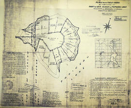
Subdivision of part of Big Island on Papineau Lake
Part of Map collection
A certified reproduction of the "Subdivision of part of Big Island in Papineau Lake, Township of Bangor & Wicklow - for Dept. Lands & Forests.” The area includes; Big Island in Papineau Lake, Lots # 1-8 and Blocks P-I in the Township of Bangor & Wicklow. Surveyed by John Thomas Ransom, O. L. S. and signed December 1, 1960.
Donated by Walter I. Watson, P. L. S.
Ransom, John Thomas, P.L.S.

Subdivision of Lots 11-12 in the Township of Huntingdon
Part of Map collection
A certified reproduction of the "Subdivision of part Lots # 11 & 12, Concession 13, Township of Huntingdon.” The area includes; Moira Lake, old County Road Hwy 62 and proposed new bridge. Surveyed by John Thomas Ransom, O. L. S. and signed November 10, 1960.
Donated by Walter I. Watson, P. L. S.
Ransom, John Thomas, P.L.S.

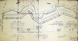
Victoria Gardens Subdivision in the City of Belleville
Part of Map collection
A certified reproduction of the "Victoria Gardens Subdivision - part of east half of Lot # 10, Concession 1, now [the] City of Belleville. Owner- Lambert-Rollins Construction Ltd.” The area includes; north of Victoria Avenue, Lots # 1 to 70 on Rollins Drive and Clifford Crescent. Surveyed by John Thomas Ransom, O. L. S. and signed October 17, 1960.
Donated by Walter I. Watson, P. L. S.
Ransom, John Thomas, P.L.S.
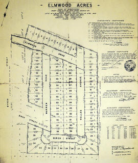
Elmwood Acres Subdivision in the Town of Trenton
Part of Map collection
A certified reproduction of the "Elmwood Acres Subdivision of part Lots # 3 & 4, part of Birch Street...Town of Trenton, County of Hastings.” The area includes; Lots # 1 to 70, west of the Township of Sidney and east of Byron Street, being Lots on Elmwood Drive, Warren Road, Nelles Avenue and Birch Street. Surveyed by John Thomas Ransom, O. L. S. and signed October 8, 1960.
Donated by Walter I. Watson, P. L. S.
Ransom, John Thomas, P.L.S.
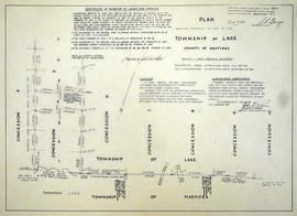
Re-survey of Lake and Marmora Township boundaries
Part of Map collection
A certified reproduction of the "Re-survey of boundaries between Township of Lake and Marmora, from Concession 4 to Concession 10; also Road allowances between Concession 5 & 6 in front of Lots # 1 to 5 in [the] Township of Lake.” Surveyed by John G. Pierce of Pierce & Pierce, O. L. S., and signed February 29, 1960.
Donated by Walter I. Watson, P. L. S.
Pierce, John Gourlay, O.L.S.

Subdivision of part of Lots 22-23 in the Township of Tudor
Part of Map collection
A certified reproduction of the "Subdivision of part of Lots # 22 and 23, Concession XIX, Township of Tudor.” The area includes; Bass Lake, Lots # 1 to 17 and Blocks A, B, C within the boundaries laid out and Austin Bay Road. Surveyed by John Thomas Ransom, O. L. S. and signed September 15, 1960.
Donated by Walter I. Watson, P. L. S.
Ransom, John Thomas, P.L.S.

Subdivision of part of Lots 1-2 in the Township of Wicklow
Part of Map collection
A certified reproduction of the "Subdivision of part of Lot # 1, Concession XI, part of Lot # 2, Concession XII, Township of Wicklow, prepared for Dept. Lands & Forests.” The area includes; Lots # 1 to 11, Lots # 1A, 2A, 3A, 4A, on the northeast shore of Papineau Lake. Surveyed by M. J. McAlpine, O. L. S. and signed June 3, 1960.
Donated by Walter I. Watson, P. L. S.
McAlpine, Michael Joseph, O.L.S.

Subdivision of part of Lots 3-4 in the Township of Wicklow
Part of Map collection
A certified reproduction of the "Subdivision of parts of Lots # 3 & 4, Concession XII, Township of Wicklow, prepared for Dept. Lands and Forests.” The area includes; Bark Lake, and the subdivision at the south end of Harris Bay, Township of Wicklow. Surveyed by M.J. McAlpine, O. L. S. and signed December 24, 1959.
Donated by Walter I. Watson, P. L. S.
McAlpine, Michael Joseph, O.L.S.

Subdivision of part of Lot 25 in the Township of Bangor
Part of Map collection
A certified reproduction of the "Subdivision of part of Lot # 25, Concession VIII, Township of Bangor, prepared for Dept. Lands & Forests.” The area includes; Lots # 1 to 7, Lot # 1A and Road Allowance southwest shore of Kaminiskeg Lake. Surveyed by M.J. McAlpine, O. L. S. and signed December 24, 1959.
Donated by Walter I. Watson, P. L. S.
McAlpine, Michael Joseph, O.L.S.
Map of Federal Electoral Boundaries in Ontario as per the Readjustment Act
Part of Map collection
A book explaining and showing the 'new' federal electoral boundaries in Ontario as per the Readjustment Act.
Electoral Boundaries Commission for Ontario
Canada Map Index 1 from the National Topographic System
Part of Map collection
A topographical map of Ontario from the Canada Index 1, Maps of the National Topographic System of Canada. Published by the Department of Mines and Resources (now the Department of Natural Resources). Dated July 1991. Scale 1:50,000.
Canada. Department of Natural Resources